Country:
 Switzerland
Region:
City:
Latitude and Longitude:
Time Zone:
Postal Code:
IP information under different IP Channel
ip-api
Country
Region
City
ASN
Time Zone
ISP
Blacklist
Proxy
Latitude
Longitude
Postal
Route
IPinfo
Country
Region
City
ASN
Time Zone
ISP
Blacklist
Proxy
Latitude
Longitude
Postal
Route
MaxMind
Country
Region
City
ASN
Time Zone
ISP
Blacklist
Proxy
Latitude
Longitude
Postal
Route
Luminati
Country
CHASN
Time Zone
Europe/Zurich
ISP
senseLAN GmbH
Latitude
Longitude
Postal
db-ip
Country
Region
City
ASN
Time Zone
ISP
Blacklist
Proxy
Latitude
Longitude
Postal
Route
ipdata
Country
Region
City
ASN
Time Zone
ISP
Blacklist
Proxy
Latitude
Longitude
Postal
Route
Popular places and events near this IP address

Guggisberg
Municipality in Bern, Switzerland
Distance: Approx. 313 meters
Latitude and longitude: 46.76666667,7.33333333
Guggisberg (Bernese German Guggishbärg [ˈgʊkisbærg]) is a municipality in the Bern-Mittelland administrative district in the Swiss canton of Bern.

Rüschegg
Municipality in Bern, Switzerland
Distance: Approx. 4109 meters
Latitude and longitude: 46.76666667,7.38333333
Rüschegg is a municipality in the Bern-Mittelland administrative district in the canton of Bern in Switzerland. It is also a Swiss Reformed Church parish.
Wahlern
Former municipality in Bern, Switzerland
Distance: Approx. 5682 meters
Latitude and longitude: 46.81666667,7.35
Wahlern is a former municipality of the canton of Bern in Switzerland and seat of the Bern-Mittelland administrative district. On 1 January 2011, the former municipalities of Wahlern and Albligen merged in the new municipality of Schwarzenburg.

Schwarzenburg
Municipality in Bern, Switzerland
Distance: Approx. 5470 meters
Latitude and longitude: 46.81666667,7.33333333
Schwarzenburg is a municipality in the district of Bern-Mittelland in the canton of Bern in Switzerland. It was created on 1 January 2011 through the merger of the municipalities of Wahlern and Albligen.
Brünisried
Municipality in Fribourg, Switzerland
Distance: Approx. 3519 meters
Latitude and longitude: 46.76666667,7.28333333
Brünisried is a municipality in the district of Sense in the canton of Fribourg in Switzerland. It is one of the municipalities with a large majority of German speakers in the mostly French speaking Canton of Fribourg.

Oberschrot
Former municipality in Fribourg, Switzerland
Distance: Approx. 4027 meters
Latitude and longitude: 46.75,7.28333333
Oberschrot was a municipality in the district of Sense in the canton of Fribourg in Switzerland. It is one of the municipalities with a large majority of German speakers in the mostly French speaking Canton of Fribourg. On January 1, 2017, the former municipalities of Oberschrot and Zumholz merged into the municipality of Plaffeien.

Plaffeien
Municipality in Fribourg, Switzerland
Distance: Approx. 5189 meters
Latitude and longitude: 46.73333333,7.28333333
Plaffeien (French: Planfayon; Arpitan: Pllanfayon [plɑ̃faˈjɔ̃] ) is a municipality in the district of Sense in the canton of Fribourg in Switzerland. It is one of the municipalities with a large majority of German speakers in the mostly French speaking Canton of Fribourg.

Zumholz
Former municipality in Fribourg, Switzerland
Distance: Approx. 2981 meters
Latitude and longitude: 46.75,7.3
Zumholz is a former municipality in the district of Sense in the canton of Fribourg in Switzerland. It is one of the municipalities with a large majority of German speakers in the mostly French speaking Canton of Fribourg. On 1 January 2017 the former municipalities of Zumholz and Oberschrot merged into the municipality of Plaffeien.
Schwarzenbühl Pass
Distance: Approx. 4552 meters
Latitude and longitude: 46.75,7.38333333
Schwarzenbühl Pass (el. 1547 m.) is a high mountain pass in the Alps in the canton of Bern in Switzerland. It connects Riffenmatt in the municipality of Guggisberg, south of Bern and Gurnigel Pass.

Schwarzenburg Castle
Distance: Approx. 5360 meters
Latitude and longitude: 46.815049,7.341401
Schwarzenburg Castle (German: Schloss Schwarzenburg) is a castle in the municipality of Schwarzenburg of the Canton of Bern in Switzerland. It is a Swiss heritage site of national significance.

Pfyffe
Mountain in Switzerland
Distance: Approx. 4360 meters
Latitude and longitude: 46.74138889,7.37194444
The Pfyffe is a mountain of the Bernese Alpine foothills located between the municipalities of Guggisberg and Rüschegg in the canton of Bern. It is part of the wooded range north of the Gurnigel Pass, which culminates at the Selibüel. On the southern slopes of the mountain lies the small resort of Ottenleuebad (1,430 m).
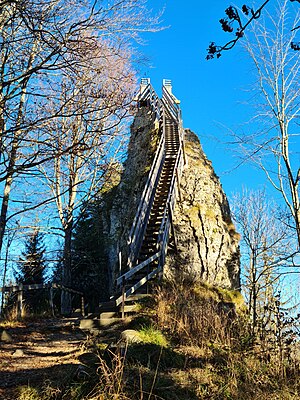
Guggershorn
Distance: Approx. 456 meters
Latitude and longitude: 46.77,7.3343
Guggershorn (or Guggershörnli) is a nagelfluh mountain (1283 m a.s.l.) with a conspicuous summit rock in the Bernese Prealps, northeast above Guggisberg in Switzwrland. In 1828, the Sternenwirt Blaser built a staircase on the summit rock as a tourist attraction. The Guggershorn with its viewing platform and panorama board has been a popular excursion destination ever since.
Weather in this IP's area
light rain
8 Celsius
8 Celsius
7 Celsius
10 Celsius
1019 hPa
85 %
1019 hPa
894 hPa
10000 meters
0.97 m/s
1.19 m/s
190 degree
99 %
07:48:35
18:43:52