Country:
 Switzerland
Region:
City:
Latitude and Longitude:
Time Zone:
Postal Code:
IP information under different IP Channel
ip-api
Country
Region
City
ASN
Time Zone
ISP
Blacklist
Proxy
Latitude
Longitude
Postal
Route
IPinfo
Country
Region
City
ASN
Time Zone
ISP
Blacklist
Proxy
Latitude
Longitude
Postal
Route
MaxMind
Country
Region
City
ASN
Time Zone
ISP
Blacklist
Proxy
Latitude
Longitude
Postal
Route
Luminati
Country
CHASN
Time Zone
Europe/Zurich
ISP
green.ch AG
Latitude
Longitude
Postal
db-ip
Country
Region
City
ASN
Time Zone
ISP
Blacklist
Proxy
Latitude
Longitude
Postal
Route
ipdata
Country
Region
City
ASN
Time Zone
ISP
Blacklist
Proxy
Latitude
Longitude
Postal
Route
Popular places and events near this IP address

Chur
Capital of the Grisons, Switzerland
Distance: Approx. 1904 meters
Latitude and longitude: 46.85,9.53333333
Chur (German: [ˈkuːr] (locally) or [ˈxuːr]; Italian: Coira [ˈkɔira]; Sursilvan: Cuera [ˈkweːʁə] ; Vallader: Cuoira [ˈkuɔ̯jrɐ] ; Puter and Rumantsch Grischun: Cuira [ˈkujrɐ] ; Surmiran: Coira; Sutsilvan: Cuera or Cuira; French: Coire [kwaʁ]) is the capital and largest town of the Swiss canton of the Grisons and lies in the Grisonian Rhine Valley, where the Rhine turns towards the north, in the northern part of the canton. The city, on the right bank of the Rhine, is reputedly the oldest town in Switzerland. The official language of Chur is German, but the main spoken language is the local variant of Alemannic, known as Grisonian German.

Graubündner Kantonalbank
Cantonal bank based in Chur, Switzerland
Distance: Approx. 1802 meters
Latitude and longitude: 46.8505,9.5319
The Graubündner Kantonalbank (known as Banca Chantunala Grischuna in Romansh or Banca Cantonale Grigione in Italian) is a Swiss cantonal bank which is part of the 24 cantonal banks serving Switzerland's 26 cantons. The headquarters are located in Chur, and there are 45 branches around Graubünden.

Chur Wiesental railway station
Railway station in Switzerland
Distance: Approx. 2323 meters
Latitude and longitude: 46.86188889,9.5315
Chur Wiesental railway station is a railway station in the northern part of the town of Chur, the capital of the Swiss canton of Grisons. The station is on the Rhaetian Railway's single-track 1,000 mm (3 ft 3+3⁄8 in) metre gauge Landquart–Thusis line, and has one side platform. The two-track SBB line runs parallel but has no intermediate stops between Chur and Landquart.

Chur railway station
Railway station in Graubünden, Switzerland
Distance: Approx. 1649 meters
Latitude and longitude: 46.85308,9.52891889
Chur railway station (German: Bahnhof Chur) serves the town of Chur, capital of the canton of Graubünden, Switzerland. Opened in 1858, it is the most important railway junction in Graubünden. The station is the terminus of the Swiss Federal Railways (SBB CFF FFS) standard-gauge main line from Zürich, and is also one of the most important stations on the Rhaetian Railway (RhB) metre-gauge network.

Felsberg railway station
Railway station in Domat/Ems, Switzerland
Distance: Approx. 2149 meters
Latitude and longitude: 46.8431,9.48125
Felsberg railway station is a railway station in Domat/Ems, Switzerland. It takes its name from Felsberg, on the opposite side of the Rhine. It is located on the Landquart–Thusis line of the Rhaetian Railway.
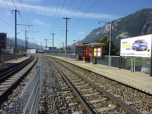
Chur West railway station
Railway station in Switzerland
Distance: Approx. 376 meters
Latitude and longitude: 46.84993889,9.51271111
Chur West railway station is a railway station in Chur, Switzerland. It is located on the Landquart–Thusis line of the Rhaetian Railway. It is served twice hourly by Chur S-Bahn trains in each direction.

Chur Altstadt railway station
Railway station in Switzerland
Distance: Approx. 1728 meters
Latitude and longitude: 46.84750389,9.53115
Chur Altstadt railway station is a small railway station (essentially a street halt) on the Chur–Arosa railway (the "Arosabahn") of the Rhaetian Railway (RhB). It is situated near the old town (Altstadt) of Chur, on Plessurquai by the Plessur river, less than a kilometre (0.76 km) from the main railway station of the city. It was called Chur Stadt railway station until 8 December 2018.
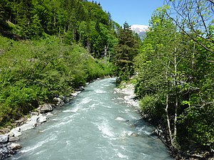
Plessur (river)
River in Switzerland
Distance: Approx. 1626 meters
Latitude and longitude: 46.86277778,9.50722222
The Plessur is a river, 33 km (21 mi) long, and a right tributary of the Rhine running through the Swiss canton of Graubünden. Its head is near Arosa in the Plessur Range. It then flows through the Schanfigg valley before emptying into the Rhine at Chur.

Cantonal School of Graubünden
High school in Graubünden, Switzerland
Distance: Approx. 2147 meters
Latitude and longitude: 46.84833333,9.53666667
The Cantonal School of Graubünden (German: Bündner Kantonsschule, also known as Kantonsschule Halde; Romansh: Scola chantunala grischuna; Italian: Scuola cantonale grigione) is the largest high school in the Swiss canton of Graubünden. It is located at the Alte Schanfiggerstrasse / Arosastrasse 2 next to the Theological College in Chur.
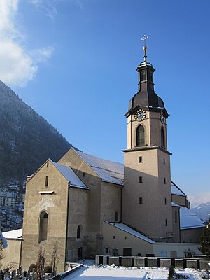
Chur Cathedral
Church in Chur, Switzerland
Distance: Approx. 2042 meters
Latitude and longitude: 46.84777778,9.53527778
Chur Cathedral, otherwise known as the Cathedral of the Assumption of Mary (German: Kathedrale St. Mariä Himmelfahrt), is the Catholic cathedral of the diocese of Chur in Switzerland. The episcopal palace of the bishop of Chur is beside the church.

Calanda Bräu
Swiss brewery
Distance: Approx. 1117 meters
Latitude and longitude: 46.8475,9.5231
Calanda Bräu (German for "Calanda Brew") is a brewery in Chur, in the Canton of Graubünden, Switzerland, owned by Heineken N.V. Its lagers, brewed using Alpine spring water, are available across Switzerland.
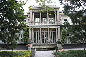
Bündner Kunstmuseum
Swiss art museum
Distance: Approx. 1852 meters
Latitude and longitude: 46.851332,9.53236
Bündner Kunstmuseum (English: Graubünden Art Museum) is a Swiss art museum founded in 1919, and located in Chur, Switzerland.
Weather in this IP's area
light rain
15 Celsius
15 Celsius
13 Celsius
18 Celsius
1018 hPa
58 %
1018 hPa
952 hPa
10000 meters
0.49 m/s
1.01 m/s
6 degree
100 %
07:45:37
18:27:49