Country:
 Netherlands
Region:
City:
Latitude and Longitude:
Time Zone:
Postal Code:
IP information under different IP Channel
ip-api
Country
Region
City
ASN
Time Zone
ISP
Blacklist
Proxy
Latitude
Longitude
Postal
Route
IPinfo
Country
Region
City
ASN
Time Zone
ISP
Blacklist
Proxy
Latitude
Longitude
Postal
Route
MaxMind
Country
Region
City
ASN
Time Zone
ISP
Blacklist
Proxy
Latitude
Longitude
Postal
Route
Luminati
Country
 CH
CHASN
Time Zone
Europe/Zurich
ISP
VTX Services SA
Latitude
Longitude
Postal
db-ip
Country
Region
City
ASN
Time Zone
ISP
Blacklist
Proxy
Latitude
Longitude
Postal
Route
ipdata
Country
Region
City
ASN
Time Zone
ISP
Blacklist
Proxy
Latitude
Longitude
Postal
Route
Popular places and events near this IP address
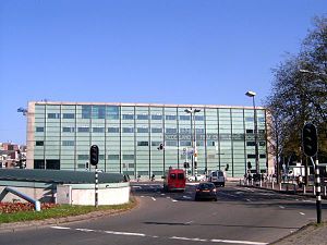
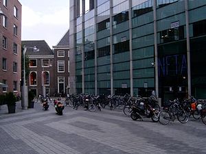
Netherlands Film Academy
Distance: Approx. 91 meters
Latitude and longitude: 52.36833333,4.90472222
The Netherlands Film Academy (Dutch: Nederlandse Filmacademie) (NFA) was founded in 1958. The academy is the only recognised institute in the Netherlands that offers training to prepare for the work in the various crew disciplines. Specialisation is possible in fiction directing, documentary directing, screenwriting, editing, producing, sounddesign, cinematography, production design, and interactive multimedia/visual effects.

Stopera
Complex with city hall and opera in Amsterdam
Distance: Approx. 173 meters
Latitude and longitude: 52.36722222,4.90166667
The Stopera is a building complex in Amsterdam, Netherlands, housing both the city hall of Amsterdam and the Dutch National Opera and Ballet (formerly Het Muziektheater), the principal opera house in Amsterdam that is home of Dutch National Opera, Dutch National Ballet and Holland Symfonia. The building was designed by Wilhelm Holzbauer and Cees Dam. The name is an abbreviation of the protest slogan "Stop the Opera" and not a portmanteau of "st"adhuis (Dutch: "city hall") and "opera" as is often claimed.
Markenplein
Distance: Approx. 136 meters
Latitude and longitude: 52.3686,4.9053
Markenplein (Marken Square) is the name of a square in the centre of Amsterdam. Until 1970, it was called het oude Markenpleintje and before World War II it used to be a part of the Jewish district of Amsterdam. The name Markenplein symbolizes the bond between the new neighborhood and the old Jewish neighborhood.

Portuguese Synagogue (Amsterdam)
Orthodox synagogue in Amsterdam, Netherlands
Distance: Approx. 86 meters
Latitude and longitude: 52.3675,4.9054
The Portuguese Synagogue, also known as the Esnoga, or Snoge, is an Orthodox Jewish congregation and synagogue, located at Mr. Visserplein 3 in Central Amsterdam, Amsterdam, in the North Holland region of The Netherlands. The synagogue was completed in 1675.

Joods Historisch Museum
History museum in Amsterdam, Netherlands
Distance: Approx. 73 meters
Latitude and longitude: 52.36694444,4.90402778
The Joods Museum (Dutch pronunciation: [ˌjoːts ɦɪsˈtoːris myˈzeːjʏm]; English: Jewish Museum), part of the Jewish Cultural Quarter, is a museum in Amsterdam dedicated to Jewish history, culture and religion, in the Netherlands and worldwide. It is the only museum in the Netherlands dedicated to Jewish history.
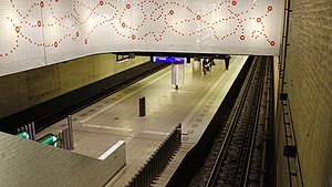
Waterlooplein metro station
Metro station in Amsterdam
Distance: Approx. 173 meters
Latitude and longitude: 52.36722222,4.90166667
Waterlooplein is an underground metro station in the city centre of Amsterdam, Netherlands. Served by metro lines 51, 53 and 54 of the Amsterdam Metro, the station was constructed by sinking caissons with a length of 40 metres (130 ft), with the first one being lowered in 1972. There were "open tube" days in 1975 showcasing the station, which was the first time the public got access to the underground tunnels of the metro system.

290 Square Meters
Retail shop in Amsterdam, Netherlands
Distance: Approx. 183 meters
Latitude and longitude: 52.36880556,4.90230556
290 Square Meters was a retail shop in Amsterdam, Netherlands. It offered men's and women's fashion as well as limited edition books, jewelry and scents. 290 Square Meters was best known for being the only retail location in the world where one could buy customized NikeID shoes for a number of years.

Mozes en Aäronkerk
Distance: Approx. 89 meters
Latitude and longitude: 52.36805556,4.90305556
The Moses and Aaron Church (Dutch: Mozes en Aäronkerk, pronounced [ˌmoːzəs ɛn aːˈʔaːrəŋkɛr(ə)k]), in the Waterlooplein neighborhood of Amsterdam, is officially the Roman Catholic Church of St. Anthony of Padua (Dutch: Sint-Anthoniuskerk). Originally a clandestine church, it was operated by Franciscan priests at a house on Jodenbreestraat ["Jewish Broad Street"], where the wall tablets of Moses and Aaron hung on the wall.

Reinwardt Academie
Distance: Approx. 185 meters
Latitude and longitude: 52.36619444,4.90558333
De Reinwardt Academie is a Dutch institution for higher vocational education in the Netherlands, which offers bachelor's (in Dutch) and master's (in English) degrees in Cultural heritage. The school is named for botanist Caspar Georg Carl Reinwardt, and is part of the Amsterdam University of the Arts (AHK). It is the only AHK-program without entrance examination, with students coming from all over Western Europe.

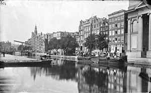
Nieuwe Herengracht
Canal in Amsterdam
Distance: Approx. 167 meters
Latitude and longitude: 52.366894,4.906301
The Nieuwe Herengracht (Dutch pronunciation: [ˌniu.ə ˈɦeːrə(ŋ)ˌɣrɑxt]) is a canal in Centrum district of Amsterdam. The canal is an extension of the Herengracht that runs between the Amstel and the Scharrebiersluis (lock) leading to the Schippersgracht from the Entrepotdok. It is in the Plantage neighborhood in the eastern part of the Grachtengordel (canal belt).

Leprozengracht
Canal in Amsterdam
Distance: Approx. 127 meters
Latitude and longitude: 52.36734,4.902323
The Leprozengracht was a canal in Amsterdam that defined one side of the Vlooienburg island. Leprozengracht and the connected Houtgracht canal were filled in 1882 to form the Waterlooplein.
Houtgracht
Canal in Amsterdam
Distance: Approx. 175 meters
Latitude and longitude: 52.368391,4.90191
The Houtgracht (Dutch pronunciation: [ˈɦʌutˌxrɑxt]; Wood Canal) was a canal in Amsterdam that defined one side of Vlooienburg island. Houtgracht and the connected Leprozengracht canal were filled in 1882 to form the Waterlooplein.
Weather in this IP's area
clear sky
20 Celsius
20 Celsius
19 Celsius
21 Celsius
1010 hPa
70 %
1010 hPa
1009 hPa
10000 meters
5.14 m/s
60 degree
07:00:28
20:17:14