194.147.112.189 - IP Lookup: Free IP Address Lookup, Postal Code Lookup, IP Location Lookup, IP ASN, Public IP
Country:
 Switzerland
Region:
City:
Location:
Time Zone:
Postal Code:
ISP:
ASN:
language:
User-Agent:
Proxy IP:
Blacklist:
IP information under different IP Channel
ip-api
Country
Region
City
ASN
Time Zone
ISP
Blacklist
Proxy
Latitude
Longitude
Postal
Route
db-ip
Country
Region
City
ASN
Time Zone
ISP
Blacklist
Proxy
Latitude
Longitude
Postal
Route
IPinfo
Country
Region
City
ASN
Time Zone
ISP
Blacklist
Proxy
Latitude
Longitude
Postal
Route
IP2Location
194.147.112.189Country
chRegion
solothurn
City
derendingen
Time Zone
Europe/Zurich
ISP
Language
User-Agent
Latitude
Longitude
Postal
ipdata
Country
Region
City
ASN
Time Zone
ISP
Blacklist
Proxy
Latitude
Longitude
Postal
Route
Popular places and events near this IP address

Emme (river)
River in Switzerland
Distance: Approx. 2584 meters
Latitude and longitude: 47.2186,7.5713
The Emme (German pronunciation: [ˈɛmə]) is a river in Switzerland. It rises in the Alps between the peaks of Hohgant and Augstmatthorn in the canton of Bern. The Emme is 80 kilometres (50 miles) long and flows through the Emmental and between Zuchwil and Luterbach into the Aare.

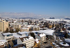
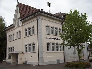
Derendingen, Switzerland
Municipality in Solothurn, Switzerland
Distance: Approx. 418 meters
Latitude and longitude: 47.2,7.58333333
Derendingen is a municipality in the district of Wasseramt in the canton of Solothurn in Switzerland.
Biberist
Municipality in Solothurn, Switzerland
Distance: Approx. 2357 meters
Latitude and longitude: 47.18333333,7.56666667
Biberist is a municipality in the district of Wasseramt in the canton of Solothurn in Switzerland.

Deitingen
Municipality in Solothurn, Switzerland
Distance: Approx. 2943 meters
Latitude and longitude: 47.21666667,7.61666667
Deitingen is a municipality in the district of Wasseramt in the canton of Solothurn in Switzerland.

Horriwil
Municipality in Solothurn, Switzerland
Distance: Approx. 2725 meters
Latitude and longitude: 47.18333333,7.61666667
Horriwil is a municipality in the district of Wasseramt in the canton of Solothurn in Switzerland.

Kriegstetten
Municipality in Solothurn, Switzerland
Distance: Approx. 1903 meters
Latitude and longitude: 47.18333333,7.6
Kriegstetten is a municipality in the district of Wasseramt in the canton of Solothurn in Switzerland.
Luterbach
Municipality in Solothurn, Switzerland
Distance: Approx. 2058 meters
Latitude and longitude: 47.21666667,7.58333333
Luterbach is a municipality in the district of Wasseramt in the canton of Solothurn in Switzerland.

Oekingen
Municipality in Solothurn, Switzerland
Distance: Approx. 1903 meters
Latitude and longitude: 47.18333333,7.6
Oekingen is a municipality in the district of Wasseramt in the canton of Solothurn in Switzerland.
Subingen
Municipality in Solothurn, Switzerland
Distance: Approx. 2144 meters
Latitude and longitude: 47.2,7.61666667
Subingen is a municipality in the district of Wasseramt in the canton of Solothurn in Switzerland.

Zuchwil
Municipality in Solothurn, Switzerland
Distance: Approx. 1652 meters
Latitude and longitude: 47.2,7.56666667
Zuchwil is a municipality in the district of Wasseramt in the canton of Solothurn in Switzerland.

Luterbach-Attisholz railway station
Railway station in Switzerland
Distance: Approx. 2108 meters
Latitude and longitude: 47.21714889,7.58352306
Luterbach-Attisholz railway station (German: Bahnhof Luterbach-Attisholz) is a railway station in the municipality of Luterbach, in the Swiss canton of Solothurn. It is an intermediate stop on the standard gauge Jura Foot line and is served by local trains only.

Biberist Ost railway station
Railway station in Biberist, Switzerland
Distance: Approx. 2567 meters
Latitude and longitude: 47.18111111,7.56611111
Biberist Ost railway station (German: Bahnhof Biberist Ost) is a railway station in the municipality of Biberist, in the Swiss canton of Solothurn. It is an intermediate stop on the standard gauge Solothurn–Langnau line of BLS AG. The station is located on the east side of the Emme, opposite the Biberist city center. Another station, Biberist RBS on the 1,000 mm (3 ft 3+3⁄8 in) gauge Solothurn–Worblaufen line of Regionalverkehr Bern-Solothurn, is located approximately 1 kilometre (0.62 mi) to the west.
Weather in this IP's area
mist
5 Celsius
5 Celsius
5 Celsius
6 Celsius
1021 hPa
99 %
1021 hPa
943 hPa
4500 meters
1.03 m/s
80 degree
100 %