Country:
Region:
City:
Latitude and Longitude:
Time Zone:
Postal Code:
IP information under different IP Channel
ip-api
Country
Region
City
ASN
Time Zone
ISP
Blacklist
Proxy
Latitude
Longitude
Postal
Route
Luminati
Country
Region
43
City
haneda
ASN
Time Zone
Asia/Tokyo
ISP
SALESFORCE
Latitude
Longitude
Postal
IPinfo
Country
Region
City
ASN
Time Zone
ISP
Blacklist
Proxy
Latitude
Longitude
Postal
Route
db-ip
Country
Region
City
ASN
Time Zone
ISP
Blacklist
Proxy
Latitude
Longitude
Postal
Route
ipdata
Country
Region
City
ASN
Time Zone
ISP
Blacklist
Proxy
Latitude
Longitude
Postal
Route
Popular places and events near this IP address

Hitoyoshi, Kumamoto
City in Kyushu, Japan
Distance: Approx. 4291 meters
Latitude and longitude: 32.21027778,130.7625
Hitoyoshi (人吉市, Hitoyoshi-shi) is a city in Kumamoto Prefecture, Japan. As of 31 August 2024, the city had an estimated population of 29,842 in 15292 households, and a population density of 140 persons per km2. The total area of the city is 210.55 km2 (81.29 sq mi).
Sagara, Kumamoto
Village in Kyushu, Japan
Distance: Approx. 6852 meters
Latitude and longitude: 32.23527778,130.79777778
Sagara (相良村, Sagara-mura) is a village located in Kuma District, Kumamoto Prefecture, Japan. located in Kuma District, Kumamoto Prefecture, Japan. As of 31 August 2024, the village had an estimated population of 3987 in 1589 households, and a population density of 42 persons per km2.
Yamae, Kumamoto
Village in Kyushu, Japan
Distance: Approx. 4228 meters
Latitude and longitude: 32.24666667,130.76666667
Yamae (山江村, Yamae-mura) is a village located in Kuma District, Kumamoto Prefecture, Japan. As of 31 August 2024, the village had an estimated population of 3,177 in 1194 households, and a population density of 26 persons per km2. The total area of the village is 121.19 km2 (46.79 sq mi).

Hitoyoshi Station
Railway station in Hitoyoshi, Kumamoto Prefecture, Japan
Distance: Approx. 3251 meters
Latitude and longitude: 32.21583333,130.75361111
Hitoyoshi Station (人吉駅, Hitoyoshi-eki) is a railway station on the Hisatsu Line and Yunomae Line in Hitoyoshi, Kumamoto, Japan, operated by Kyushu Railway Company (JR Kyushu) and Kumagawa Railroad. The name of the Yunomae Line station is officially Hitoyoshi-Onsen Station (人吉温泉駅, Hitoyoshi-Onsen-eki), which was renamed from Hitoyoshi Station on April 1, 2009.

Aoi Aso Shrine
Shinto shrine in Hitoyoshi, Kumamoto Prefecture, Japan
Distance: Approx. 3354 meters
Latitude and longitude: 32.21333333,130.75277778
Aoi Aso Shrine (青井阿蘇神社, Aoi Aso Jinja) is a Shinto shrine in Hitoyoshi, Kumamoto Prefecture, Japan. It is colloquially known as Aoi-san (青井さん). It was originally established as a prefectural shrine, but is currently designated as a national shrine (別表神社, Beppyo Jinja).
Isshōchi Station
Railway station in Kuma, Kumamoto Prefecture, Japan
Distance: Approx. 7123 meters
Latitude and longitude: 32.25027778,130.6525
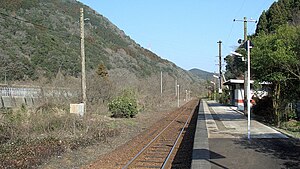
Isshōchi Station (一勝地駅, Isshōchi-eki) is a railway station on the Hisatsu Line in Kuma, Kumamoto, Japan, operated by Kyushu Railway Company (JR Kyushu).
Naraguchi Station
Railway station in Kuma, Kumamoto Prefecture, Japan
Distance: Approx. 5542 meters
Latitude and longitude: 32.24361111,130.66777778
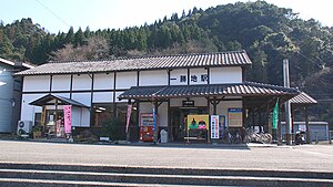
Naraguchi Station (那良口駅, Naraguchi-eki) is a railway station on the Hisatsu Line in Kuma, Kumamoto, Japan, operated by Kyushu Railway Company (JR Kyushu).
Watari Station (Kumamoto)
Railway station in Kuma, Kumamoto Prefecture, Japan
Distance: Approx. 2901 meters
Latitude and longitude: 32.23666667,130.69472222
Watari Station (渡駅, Watari-eki) is a railway station on the Hisatsu Line in Kuma, Kumamoto, Japan, operated by Kyushu Railway Company (JR Kyushu).
Nishi-Hitoyoshi Station
Railway station in Hitoyoshi, Kumamoto Prefecture, Japan
Distance: Approx. 413 meters
Latitude and longitude: 32.22861111,130.72555556
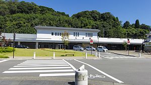
Nishi-Hitoyoshi Station (西人吉駅, Nishi-Hitoyoshi-eki) is a railway station on the Hisatsu Line in Hitoyoshi, Kumamoto, Japan, operated by Kyushu Railway Company (JR Kyushu).

Hitoyoshi Castle
Castle ruins in Hitoyoshi, Kumamoto, Japan
Distance: Approx. 4558 meters
Latitude and longitude: 32.21108333,130.76649167
Hitoyoshi Castle (人吉城, Hitoyoshi-jō) was an Edo period flatlands-style Japanese castle located in the city of Hitoyoshi, Kumamoto Prefecture, Japan. Its ruins have been protected as a National Historic Site since 1961. It is No.93 on the list "100 Fine Castles of Japan".

Sagarahan-Ganjōji Station
Railway station in Hitoyoshi, Kumamoto Prefecture, Japan
Distance: Approx. 4463 meters
Latitude and longitude: 32.21841389,130.76956389
Sagarahan-Ganjōji Station (相良藩願成寺駅, Sagarahan ganjōji eki) is a railway station in Hitoyoshi, Kumamoto Prefecture, Japan. It is on the Kumagawa Railroad Yunomae Line. The station opened on 1 April 1937.
Ohkubo Tameike Dam
Dam in Kumamoto Prefecture, Japan
Distance: Approx. 5544 meters
Latitude and longitude: 32.2175,130.66888889
Ohkubo Tameike Dam (Japanese: 大久保溜池) is an earthfill dam located in Kumamoto Prefecture in Japan. The dam is used for irrigation. The catchment area of the dam is 0.3 km2.
Weather in this IP's area
overcast clouds
20 Celsius
20 Celsius
20 Celsius
20 Celsius
1016 hPa
96 %
1016 hPa
1003 hPa
10000 meters
1.15 m/s
1.15 m/s
21 degree
100 %
06:47:11
17:16:47


