Country:
 Sweden
Region:
City:
Latitude and Longitude:
Time Zone:
Postal Code:
IP information under different IP Channel
ip-api
Country
Region
City
ASN
Time Zone
ISP
Blacklist
Proxy
Latitude
Longitude
Postal
Route
IPinfo
Country
Region
City
ASN
Time Zone
ISP
Blacklist
Proxy
Latitude
Longitude
Postal
Route
MaxMind
Country
Region
City
ASN
Time Zone
ISP
Blacklist
Proxy
Latitude
Longitude
Postal
Route
Luminati
Country
SEASN
Time Zone
Europe/Stockholm
ISP
Telenor Norge AS
Latitude
Longitude
Postal
db-ip
Country
Region
City
ASN
Time Zone
ISP
Blacklist
Proxy
Latitude
Longitude
Postal
Route
ipdata
Country
Region
City
ASN
Time Zone
ISP
Blacklist
Proxy
Latitude
Longitude
Postal
Route
Popular places and events near this IP address

Mölndal
Place in Mölndal Municipality, Sweden
Distance: Approx. 2019 meters
Latitude and longitude: 57.65,12.01666667
Mölndal (Swedish pronunciation: [ˈmœ̌lndal]) is the seat and administrative centre of Mölndal Municipality and a part of the Gothenburg urban area on the west coast of Sweden. About 40,000 of the municipality's 60,000 inhabitants live in Mölndal proper.
Askim, Sweden
Distance: Approx. 3334 meters
Latitude and longitude: 57.635,11.93138889
Askim (Swedish pronunciation: [ˈâɧːɪm]) is a district (stadsdelsnämndsområde) of the Gothenburg Municipality in Sweden, about 10 km (6 mi) south-west of the city centre. To the northwest of Askim is Västra Frölunda, to the east is Mölndal, and the sea is to the west. As a district, Askim has a local board composed of the same proportions ruling Gothenburg as a whole.

Västra Frölunda
Distance: Approx. 4142 meters
Latitude and longitude: 57.65,11.91666667
Västra Frölunda, sometimes referred to as just Frölunda, is one of 21 boroughs in the city of Gothenburg, Sweden. It is located in the south western part of the city, and is the smallest of the boroughs with a population of 12,855 (2004) on 3.72 square kilometres, although the term Frölunda generally is used for a much wider area covering almost all the city's western suburbs.
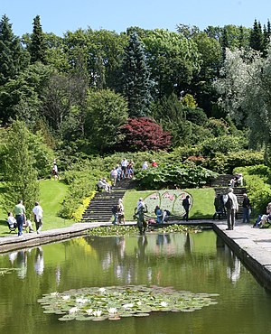
Gothenburg Botanical Garden
Botanical garden in Gothenburg, Sweden
Distance: Approx. 4542 meters
Latitude and longitude: 57.6808,11.9546
The Gothenburg Botanical Garden (Swedish: Göteborgs botaniska trädgård) is located in Gothenburg, Sweden, and is one of the larger botanical gardens in Europe.
Eklanda
Distance: Approx. 1321 meters
Latitude and longitude: 57.65,11.96666667
Eklanda is a suburban neighbourhood with 3000 inhabitants in Mölndal Municipality, part of the Gothenburg urban area. Eklanda is predominantly made up of high- and medium-income households. Eklanda is adjacent to the Högsbo 421 shopping mall and Änggårdsbergen protected area.
Hills Golf Club
Golf club in Mölndal, Sweden
Distance: Approx. 2943 meters
Latitude and longitude: 57.6214,12.0125
Hills Golf Club is a golf club located in Mölndal near Gothenburg, Sweden. It hosted the Nordea Masters in August 2018, a European Tour event.

Högsbo
Distance: Approx. 4627 meters
Latitude and longitude: 57.671,11.927
Högsbo is a city district of Gothenburg located on the Swedish west coast. Högsbo is situated southwest of the city centre of Gothenburg. The centre of Högsbo is Axel Dahlströms torg which consists of a small shopping square and connections with the Västtrafik tram system.
Dugges Ale och Porterbryggeri
Distance: Approx. 2584 meters
Latitude and longitude: 57.64416111,12.02844167
Dugges Ale- & Porterbryggeri (Dugge's Ale & Porter Brewery) is a brewery in Landvetter outside Gothenburg, Sweden. The brewery was started in 2005 by Mikael Dugge Engström and is focused on top-fermented beers, influenced by US microbreweries. The ales are brewed with many hops, such as Chinook, giving them a strong and pleasant aroma.
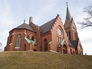
Fässberg Parish
Church in Västra Götaland, Sweden
Distance: Approx. 2060 meters
Latitude and longitude: 57.65638889,12.00972222
Fässberg Parish is a parish in the Diocese of Gothenburg in Sweden. It covers most of the town of Mölndal.

Frölunda Specialist Hospital
Hospital in Frölunda, Sweden
Distance: Approx. 4414 meters
Latitude and longitude: 57.65055556,11.91222222
Frölunda specialist hospital (Swedish: Frölunda Specialistsjukhus) is located in Frölunda, right next to Frölunda torg, approximately nine kilometres south-west of central Gothenburg. The hospital primarily operate with elective care, with specialist in otolaryngology, neurology, gynaecology, orthopedic surgery, medicine, dermatology, ophthalmology, surgery, and radiography. The hospital was inaugurated in 1968 as a local hospital for people living in Tynnered, Frölunda, and Älvsborg.
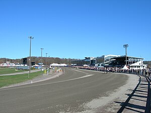
Åby Racetrack
Horse racing track in Mölndal, near Gothenburg, Sweden
Distance: Approx. 1227 meters
Latitude and longitude: 57.6504,12.001
Åby Racetrack (Swedish: Åbytravet) is a horse racing track located in Mölndal, 10 km south of Gothenburg, Sweden. Åby was opened in 1936 as a track for harness racing as well as thoroughbred racing. Since October 1976, the track has been dedicated to harness racing solely.
Johanneberg Science Park
Distance: Approx. 4622 meters
Latitude and longitude: 57.68474722,11.97796667
Johanneberg Science Park was established in December 2009 by the Chalmers University of Technology Foundation and the City of Gothenburg to create better conditions for regional sustainable growth, based on the activities currently conducted within Chalmers University of Technology at Campus Johanneberg in Gothenburg, Sweden. The Science Park primarily support development of activities within the disciplines of Urban Development, Environment, Energy, Materials and Nanoscience.
Weather in this IP's area
mist
10 Celsius
10 Celsius
9 Celsius
11 Celsius
1004 hPa
94 %
1004 hPa
1001 hPa
3400 meters
4.12 m/s
130 degree
100 %
07:31:28
18:27:17