194.135.46.178 - IP Lookup: Free IP Address Lookup, Postal Code Lookup, IP Location Lookup, IP ASN, Public IP
Country:
Region:
City:
Location:
Time Zone:
Postal Code:
ISP:
ASN:
language:
User-Agent:
Proxy IP:
Blacklist:
IP information under different IP Channel
ip-api
Country
Region
City
ASN
Time Zone
ISP
Blacklist
Proxy
Latitude
Longitude
Postal
Route
db-ip
Country
Region
City
ASN
Time Zone
ISP
Blacklist
Proxy
Latitude
Longitude
Postal
Route
IPinfo
Country
Region
City
ASN
Time Zone
ISP
Blacklist
Proxy
Latitude
Longitude
Postal
Route
IP2Location
194.135.46.178Country
Region
yerushalayim
City
jerusalem
Time Zone
Asia/Jerusalem
ISP
Language
User-Agent
Latitude
Longitude
Postal
ipdata
Country
Region
City
ASN
Time Zone
ISP
Blacklist
Proxy
Latitude
Longitude
Postal
Route
Popular places and events near this IP address
Operation Kedem
Zionist militia plan to take East Jerusalem
Distance: Approx. 107 meters
Latitude and longitude: 31.77810556,35.2256
Operation Kedem was an action planned and carried out by Irgun and Lehi forces in July 1948, during the 1948 Arab–Israeli war. Its purpose was to capture East Jerusalem, including the Old City. After the first cease-fire of the Arab–Israeli War, which lasted for four weeks, the balance in power in Jerusalem had shifted dramatically.

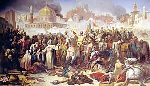
Siege of Jerusalem (1099)
Christian conquest of the First Crusade
Distance: Approx. 36 meters
Latitude and longitude: 31.77888889,35.22555556
The Siege of Jerusalem marked the successful end of the First Crusade, whose objective was the recovery of the city of Jerusalem and the Church of the Holy Sepulchre from Islamic control. The five-week siege began on 7 June 1099 and was carried out by the Christian forces of Western Europe mobilized by Pope Urban II after the Council of Clermont in 1095. The city had been out of Christian control since the Muslim conquest of the Levant in 637 and had been held for a century first by the Seljuk Turks and later by the Egyptian Fatimids.

New Gate
Gate of the Old City of Jerusalem
Distance: Approx. 108 meters
Latitude and longitude: 31.77930556,35.22627778
The New Gate (Arabic: باب الجديد Bāb ij-Jdïd) (Hebrew: השער החדש HaSha'ar HeChadash) is the newest of the gates of the Old City of Jerusalem. It was built in 1889 by the Ottomans under the directorship of the French consul and Franciscan brotherhood monkship order to provide direct access between the Christian Quarter and the new neighborhoods then going up outside the walls. The arched gate is decorated with crenelated stonework.

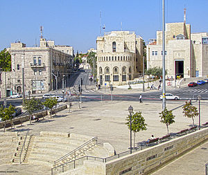
Safra Square
Square in Jerusalem
Distance: Approx. 201 meters
Latitude and longitude: 31.78041389,35.22388611
Safra Square (Hebrew: כיכר ספרא, Kikar Safra) is a city square in Jerusalem. It is the site of the Jerusalem Municipality complex, which houses the municipal administration. Safra Square is located in a central part of the city, near the former seam line between West and East Jerusalem (though falling entirely west of it), a site chosen to symbolize its goal of serving all residents of Jerusalem.
2008 Jerusalem BMW attack
Terrorist attack in Jerusalem
Distance: Approx. 23 meters
Latitude and longitude: 31.77888889,35.225
On 22 September 2008, a Palestinian drove a BMW saloon car into a group of civilians and off-duty soldiers in a terrorist ramming attack in Jerusalem, injuring 19 people. Stratfor Global Intelligence analysts say this attack represents a new terrorist tactic which is less lethal but could prove more difficult to prevent than suicide bombing.

Stern House
Distance: Approx. 182 meters
Latitude and longitude: 31.7775,35.22444444
The Stern House, (Hebrew: בית שטרן) is a preserved and reconstructed historic building in Jerusalem. The house was built in 1877 in Mamilla, one of the original neighborhoods outside the city walls, and was rescued during a major reconstruction of the same neighborhood in the late 20th and early 21st century. The Stern House is notable for accommodating Theodor Herzl during his visit to Jerusalem in 1898.

Mamilla Mall
Mall in Jerusalem, Israel
Distance: Approx. 200 meters
Latitude and longitude: 31.77731389,35.22593889
Mamilla Mall, also called Alrov Mamilla Avenue, is an upscale shopping street and the only open-air mall in West Jerusalem. Located northwest of Jaffa Gate, the mall consists of a 2,000-foot (610 m) pedestrian promenade called Alrov Mamilla Avenue lined by 140 stores, restaurants, and cafes, and office space on upper floors. It sits atop a multi-story parking garage for 1,600 cars and buses, and a bus terminal.

Jerusalem Old Town Hall
Former municipal building
Distance: Approx. 52 meters
Latitude and longitude: 31.7792,35.2247
Jerusalem's old town hall was one of the four public buildings constructed in Jerusalem by the British administration during the British Mandate.

Chapel of Saint Vincent de Paul, Jerusalem
Church in Jerusalem
Distance: Approx. 146 meters
Latitude and longitude: 31.7783,35.2239
The St. Vincent de Paul Chapel (Hebrew: מנזר סן ונסן דה פול) is a Catholic chapel that serves the Hospice of St. Vincent de Paul in Jerusalem.
2017 Jerusalem Light Rail stabbing
Terrorist attack in Israel on 14 April 2017
Distance: Approx. 47 meters
Latitude and longitude: 31.77888889,35.22472222
The 2017 Jerusalem Light Rail stabbing was a stabbing attack and suspected act of terrorism that occurred on Good Friday, 14 April 2017, on Jerusalem Light Rail's car. In the attack, a 20 year old British student was stabbed to death by Jamil Tamimi, a Palestinian man. Two others, including a pregnant woman, were injured in the incident.

Tancred's Tower
Former tower in Jerusalem's Old City walls
Distance: Approx. 96 meters
Latitude and longitude: 31.7786,35.2261
Tancred's Tower, known in Arabic as Qasr (al-)Jalud ("Goliath's Castle", see below), was a large tower at the northwest corner of the Old City of Jerusalem, of which only meager remains were unearthed by archaeologists. Today, much of the area of the original structure is beneath the Collège des Frères of the De La Salle Brothers. Parts of it are in the external base of the city wall where the section coming from the New Gate to the northeast meets the section coming from Jaffa Gate to the southeast.

Notre Dame of Jerusalem Center
Pontifical institute in Israel
Distance: Approx. 126 meters
Latitude and longitude: 31.78,35.22583333
Notre Dame of Jerusalem Center is a pontifical institute founded in 1978 with religious, cultural, and educational purposes. Its main activities are: welcoming pilgrims, divine worship, cultural education and formation of the local population, and ecumenism and inter-religious dialogue.
Weather in this IP's area
overcast clouds
10 Celsius
9 Celsius
10 Celsius
10 Celsius
1024 hPa
58 %
1024 hPa
950 hPa
10000 meters
0.69 m/s
0.69 m/s
298 degree
95 %