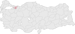
Country:
 Turkey
Region:
City:
Latitude and Longitude:
Time Zone:
Postal Code:
IP information under different IP Channel
ip-api
Country
Region
City
ASN
Time Zone
ISP
Blacklist
Proxy
Latitude
Longitude
Postal
Route
IPinfo
Country
Region
City
ASN
Time Zone
ISP
Blacklist
Proxy
Latitude
Longitude
Postal
Route
MaxMind
Country
Region
City
ASN
Time Zone
ISP
Blacklist
Proxy
Latitude
Longitude
Postal
Route
Luminati
Country
 CZ
CZASN
Time Zone
Europe/Prague
ISP
Onur Bilisim Ve Yazilim Hizmetleri
Latitude
Longitude
Postal
db-ip
Country
Region
City
ASN
Time Zone
ISP
Blacklist
Proxy
Latitude
Longitude
Postal
Route
ipdata
Country
Region
City
ASN
Time Zone
ISP
Blacklist
Proxy
Latitude
Longitude
Postal
Route
Popular places and events near this IP address

Nicomedia
Ancient city of Bithynia
Distance: Approx. 1394 meters
Latitude and longitude: 40.7625,29.9175
Nicomedia (; Greek: Νικομήδεια, Nikomedeia; modern İzmit) was an ancient Greek city located in what is now Turkey. In 286, Nicomedia became the eastern and most senior capital city of the Roman Empire (chosen by the emperor Diocletian who ruled in the east), a status which the city maintained during the Tetrarchy system (293–324). The Tetrarchy ended with the Battle of Chrysopolis (Üsküdar) in 324, when Constantine defeated Licinius and became the sole emperor.

USS Gudgeon (SS-567)
Submarine of the United States
Distance: Approx. 1513 meters
Latitude and longitude: 40.760086,29.91656
USS Gudgeon (SS/AGSS/SSAG-567), a Tang-class submarine, was the second ship of the United States Navy to be named for the gudgeon, a species of small fresh-water minnow.

USS Eversole (DD-789)
Gearing-class destroyer
Distance: Approx. 1496 meters
Latitude and longitude: 40.7600877,29.9167693
USS Eversole (DD-789) was a Gearing-class destroyer of the United States Navy, the second Navy ship named for Lieutenant (junior grade) John T. Eversole (1915–1942), a naval aviator who was killed in the Battle of Midway. She later served in the Turkish navy from 1973 to 1995 as TCG Gayret (D-352) and is now a ship museum. Eversole was launched on 8 January 1946 at the Tacoma Washington shipyard of Todd-Pacific Shipyards, Inc., Seattle, Washington; sponsored by Mrs.
Kocaeli University
Turkish public university located in Kocaeli
Distance: Approx. 552 meters
Latitude and longitude: 40.7661,29.9394
Kocaeli University (Turkish: Kocaeli Üniversitesi) is a state university in İzmit, Turkey. It was founded as the Academy of Engineering and Architecture of Kocaeli in 1976. The electrical and mechanical engineering departments, basic sciences, and department of modern languages were the original departments of the academy.
Battle of Bapheus
1302 battle of the Byzantine-Ottoman Wars
Distance: Approx. 1507 meters
Latitude and longitude: 40.7667,29.9167
The Battle of Bapheus occurred on 27 July 1302, between an Ottoman army under Osman I and a Byzantine army under George Mouzalon. The battle ended in a crucial Ottoman victory, cementing the Ottoman state and heralding the final capture of Byzantine Bithynia by the Ottomans.

Kocaeli B.B. Ice Arena
Distance: Approx. 1858 meters
Latitude and longitude: 40.77385,29.95108
Kocaeli B.B. Ice Arena (Turkish: Kocaeli B.B. Olimpik Buz Sporları Salonu), formerly Kocaeli Ice Rink, is an indoor ice skating and ice hockey arena located at Şirintepe neighborhood of Izmit in Kocaeli Province, Turkey. It was opened in 1999 and has a seating capacity of 3,600 spectators. It was built according to International Ice Hockey Federation specifications, which are given in metric units (the Imperial units given are approximations): 61 m × 30 m (200 ft × 98 ft) with a corner radius of 8.5 m (28 ft).

İzmit Clock Tower
Clock tower in İzmit, Turkey
Distance: Approx. 1214 meters
Latitude and longitude: 40.762806,29.919611
The İzmit Clock Tower (Turkish: İzmit Saat Kulesi) in İzmit, Turkey is one of many clock towers that were built throughout the Ottoman Empire as a result of the decree which was sent to the provincial governors to commemorate the 25th anniversary of Sultan Abdülhamid II's ascension to the Ottoman throne. It was designed by architect Vedat Tek upon the order of Musa Kazım Bey, the governor of İzmit, and built in 1902. Other sources name the architect of the tower as Mihran Azaryan who was an Armenian-Ottoman of Izmit origin.
İzmit
District and municipality in Kocaeli, Turkey
Distance: Approx. 607 meters
Latitude and longitude: 40.76555556,29.94055556
İzmit (Turkish pronunciation: [ˈizmit]) is a municipality and the capital district of Kocaeli Province, Turkey. Its area is 480 km2, and its population is 376,056 (2022). The capital of Kocaeli Province, it is located at the Gulf of İzmit in the Sea of Marmara, about 100 km (62 mi) east of Istanbul, on the northwestern part of Anatolia.

Pertev Pasha Mosque
Mosque in İzmit, Kocaeli, Turkey
Distance: Approx. 259 meters
Latitude and longitude: 40.7628,29.931
The Pertev Mehmet Paşa Mosque (Turkish: Pertev Paşa Camii), also known as Yeni Cuma Cami meaning "New Friday Mosque" in Turkish, is a 16th-century Ottoman mosque in the town of Izmit, Turkey. The architect was Mimar Sinan. It was built for Pertev Mehmed Paşa, an Ottoman vizier during the reigns of sultan Suleyman I and Selim II. The construction was finished in 1579.
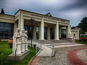
Kocaeli Museum
Archaeology museum in Kocaeli, Turkey
Distance: Approx. 1534 meters
Latitude and longitude: 40.7625,29.91583333
Kocaeli Museum, a.k.a. Kocaeli Archaeology and Ethnography Museum or İzmit Museum, Turkish: Kocaeli Müzesi) is a national museum in Kocaeli (İzmit), northwestern Turkey, exhibiting archaeological artifacts and ethnographic objects. It is housed in the former railway station of İzmit.
Kırkikievler railway station
Distance: Approx. 980 meters
Latitude and longitude: 40.762,29.9455
Kırkikievler railway station (Turkish: Kırkikievler istasyonu) was a railway station in İzmit, Turkey. It was serviced by the Adapazarı Express regional train service from Istanbul to Adapazarı. Located just south of the city center, the station was originally built in 1975 by the Turkish State Railways, when the Istanbul-Ankara railway was realigned to bypass İzmit's city center.
Kocaeli Bayan FK
Football club
Distance: Approx. 1981 meters
Latitude and longitude: 40.76444444,29.91055556
Kocaeli Bayan Futbol Kulübü, shortly Kocaeli Bayan FK, is a Turkish sole women's football sports club, based in İzmit city of Kocaeli. It was founded by Hasan Alemdaroğlu in 2016. Currently, they play in the Turkish Women's Second Football League.
Weather in this IP's area
clear sky
28 Celsius
28 Celsius
27 Celsius
28 Celsius
1009 hPa
44 %
1009 hPa
1008 hPa
10000 meters
2.57 m/s
260 degree
07:06:07
18:27:58