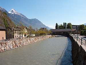
Country:
 Switzerland
Region:
City:
Latitude and Longitude:
Time Zone:
Postal Code:
IP information under different IP Channel
ip-api
Country
Region
City
ASN
Time Zone
ISP
Blacklist
Proxy
Latitude
Longitude
Postal
Route
IPinfo
Country
Region
City
ASN
Time Zone
ISP
Blacklist
Proxy
Latitude
Longitude
Postal
Route
MaxMind
Country
Region
City
ASN
Time Zone
ISP
Blacklist
Proxy
Latitude
Longitude
Postal
Route
Luminati
Country
CHRegion
vs
City
vetroz
ASN
Time Zone
Europe/Zurich
ISP
netplus.ch SA
Latitude
Longitude
Postal
db-ip
Country
Region
City
ASN
Time Zone
ISP
Blacklist
Proxy
Latitude
Longitude
Postal
Route
ipdata
Country
Region
City
ASN
Time Zone
ISP
Blacklist
Proxy
Latitude
Longitude
Postal
Route
Popular places and events near this IP address

Fully
Municipality in Valais, Switzerland
Distance: Approx. 2778 meters
Latitude and longitude: 46.13333333,7.11666667
Fully (French pronunciation: [fyji]) is a municipality in the district of Martigny in the canton of Valais in Switzerland.

Charrat
Former municipality in Valais, Switzerland
Distance: Approx. 4868 meters
Latitude and longitude: 46.11666667,7.13333333
Charrat is a former municipality in the district of Martigny in the canton of Valais in Switzerland. On 1 January 2021 the former municipality of Charrat merged into the municipality of Martigny.

Saxon, Switzerland
Municipality in Valais, Switzerland
Distance: Approx. 4193 meters
Latitude and longitude: 46.15,7.16666667
Saxon is a municipality, in the district of Martigny, in the canton of Valais, in Switzerland.
Dorénaz
Municipality in Valais, Switzerland
Distance: Approx. 4989 meters
Latitude and longitude: 46.15,7.05
Dorénaz is a municipality in the district of Saint-Maurice in the canton of Valais in Switzerland.

Lac de Fully
Reservoir in Valais, Switzerland
Distance: Approx. 2759 meters
Latitude and longitude: 46.17888889,7.09388889
Grand Lac de Fully (or Lac supérieur de Fully) is a reservoir in the canton of Valais, Switzerland. The lake's surface area is 21 ha (52 acres).
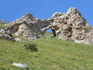
Tête du Portail
Mountain in Switzerland
Distance: Approx. 1957 meters
Latitude and longitude: 46.15905556,7.08825
The Tête du Portail (2,335 m) is a mountain located at the western extremity of the Bernese Alps, in the Swiss canton of Valais. It lies north of Martigny and Fully, in the Dent de Morcles-Grand Muveran group. The mountain is named after a natural arch, the Portail de Fully, located near the summit at a height of 2,270 metres.

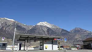
Grand Chavalard
Mountain in Switzerland
Distance: Approx. 2303 meters
Latitude and longitude: 46.17888889,7.11322222
The Grand Chavalard is a mountain in the western part of the Bernese Alps in Valais, overlooking the Rhone at Fully near Martigny. The mountain is located close to the Dent de Morcles on the north-west.
Drance
River in Switzerland
Distance: Approx. 5197 meters
Latitude and longitude: 46.12527778,7.06583333
The Drance (French: La Drance/Dranse, French pronunciation: [dʁɑ̃s]) is a river in Valais, Switzerland with a length of 14.5 kilometers (9.0 mi) to the confluence with the Rhône, a maximum length of 43 kilometers (27 mi). It has a drainage basin of 676 square kilometers (261 sq mi). The river is formed from the confluence of the Dranse d'Entremont and the Dranse de Bagnes at the village of Sembrancher.
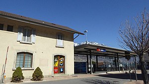
Saxon railway station
Railway station in Saxon, Switzerland
Distance: Approx. 4717 meters
Latitude and longitude: 46.14938306,7.17343611
Saxon railway station (French: Gare de Saxon, German: Bahnhof Saxon) is a railway station in the municipality of Saxon, in the Swiss canton of Valais. It is an intermediate stop on the Simplon line and is served by local trains only.
Charrat-Fully railway station
Railway station in Charrat, Switzerland
Distance: Approx. 3632 meters
Latitude and longitude: 46.12681306,7.12647694
Charrat-Fully railway station (French: Gare de Charrat-Fully, German: Bahnhof Charrat-Fully) is a railway station in the municipality of Charrat, in the Swiss canton of Valais. It is an intermediate stop on the Simplon line and is served by local trains only.

Trient (river)
River in Switzerland
Distance: Approx. 5309 meters
Latitude and longitude: 46.13777778,7.05138889
The Trient (French pronunciation: [tʁiɛ̃]) is a river in western Valais. It takes its source at the Trient Glacier in the Mont Blanc Massif and joins the Rhone between Vernayaz and Martigny. Only two villages are located along the Trient: Trient and Vernayaz.
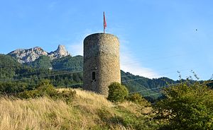
Saxon Castle
Distance: Approx. 5216 meters
Latitude and longitude: 46.14297,7.17757
Saxon Castle is a ruined castle in the municipality of Saxon of the Canton of Valais in Switzerland.
Weather in this IP's area
few clouds
6 Celsius
5 Celsius
5 Celsius
7 Celsius
1018 hPa
88 %
1018 hPa
866 hPa
10000 meters
1.8 m/s
2.16 m/s
130 degree
16 %
07:54:13
18:38:22