Country:
 Ukraine
Region:
City:
Latitude and Longitude:
Time Zone:
Postal Code:
IP information under different IP Channel
ip-api
Country
Region
City
ASN
Time Zone
ISP
Blacklist
Proxy
Latitude
Longitude
Postal
Route
IPinfo
Country
Region
City
ASN
Time Zone
ISP
Blacklist
Proxy
Latitude
Longitude
Postal
Route
MaxMind
Country
Region
City
ASN
Time Zone
ISP
Blacklist
Proxy
Latitude
Longitude
Postal
Route
Luminati
Country
UARegion
40
City
sevastopol
ASN
Time Zone
Europe/Simferopol
ISP
Lancom Ltd.
Latitude
Longitude
Postal
db-ip
Country
Region
City
ASN
Time Zone
ISP
Blacklist
Proxy
Latitude
Longitude
Postal
Route
ipdata
Country
Region
City
ASN
Time Zone
ISP
Blacklist
Proxy
Latitude
Longitude
Postal
Route
Popular places and events near this IP address

Italian battleship Giulio Cesare
Dreadnought battleship of the Italian Royal Navy
Distance: Approx. 1167 meters
Latitude and longitude: 44.61861111,33.53555556
Giulio Cesare was one of three Conte di Cavour-class dreadnought battleships built for the Royal Italian Navy (Regia Marina) in the 1910s. Completed in 1914, she was little used and saw no combat during the First World War. The ship supported operations during the Corfu Incident in 1923 and spent much of the rest of the decade in reserve.

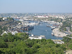
Sevastopol
City on the Crimean peninsula
Distance: Approx. 736 meters
Latitude and longitude: 44.605,33.5225
Sevastopol (), sometimes written Sebastopol, is the largest city in Crimea and a major port on the Black Sea. Due to its strategic location and the navigability of the city's harbours, Sevastopol has been an important port and naval base throughout its history. Since the city's founding in 1783 it has been a major base for Russia's Black Sea Fleet.

Siege of Sevastopol (1941–1942)
Nazi German offensive on the Eastern Front of World War II
Distance: Approx. 996 meters
Latitude and longitude: 44.60472222,33.54111111
The Siege of Sevastopol, also known as the Defence of Sevastopol (Russian: Оборона Севастополя, romanized: Oborona Sevastopolya) or the Battle of Sevastopol (German: Schlacht um Sewastopol; Romanian: Bătălia de la Sevastopol), was a military engagement that took place on the Eastern Front of the Second World War. The campaign was fought by the Axis powers of Germany and Romania against the Soviet Union for control of Sevastopol, a port in Crimea on the Black Sea. On 22 June 1941, the Axis invaded the Soviet Union during Operation Barbarossa, with Axis land forces reaching the Crimean peninsula in the autumn of 1941 and overrunning most of the area.
Sevastopol Shipyard
Shipyard in Sevastopol, Crimea
Distance: Approx. 561 meters
Latitude and longitude: 44.61251889,33.53493111
Sevastopol Shipyard ( Russian: Севастопольский морской завод, Ukrainian: Севастопольський морський завод / Севморверф, romanized: Sevmorverf, lit. 'Sevastopol Sea Wharf') is a shipyard located in Sevastopol, Crimea, founded as a dockyard for the Imperial Russian Navy in 1783. The shipyard has mostly been used to repair and maintain warships throughout its history, although it has occasionally built ships.

St. Vladimir's Cathedral, Sevastopol
Russian Orthodox church
Distance: Approx. 529 meters
Latitude and longitude: 44.61027778,33.52361111
St. Vladimir's Cathedral (Russian: Владимирский собор) is an Orthodox church in Sevastopol which was built in the aftermath of the Crimean War as a memorial to the heroes of the Siege of Sevastopol (1854–1855).

Russian destroyer Smetlivy
Soviet and Russian naval vessel
Distance: Approx. 439 meters
Latitude and longitude: 44.612833,33.529528
Smetlivy (Russian: Сметливый, lit. 'Resourceful') was a Kashin-class guided missile destroyer of the Russian Navy. Entering service in 1969, the ship served until 1991 with the fall of the Soviet Union. She returned to service in 1995 after a refit and was made part of the Black Sea Fleet.
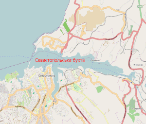
Port of Sevastopol
Main port serving the Crimean peninsula
Distance: Approx. 794 meters
Latitude and longitude: 44.61555556,33.52638889
Sevastopol Marine Trade Port (SMTP) is a port in Sevastopol. It is located mainly at the Bay of Sevastopol, and at smaller bays around the Heracles peninsula. The port infrastructure is fully integrated with the city of Sevastopol and naval bases of the Russian Navy and the Black Sea Fleet.

Cape Lazarev, Sevastopol
Cape on the Crimean Peninsula
Distance: Approx. 578 meters
Latitude and longitude: 44.61361111,33.53305556
Cape Lazarev (Russian: мыс Лазарева; Ukrainian: мис Лазарева) is a cape on the southern shore of the Sevastopol Bay (Black Sea) on the Crimean Peninsula. Cape is named after Russian fleet commander and explorer Mikhail Petrovich Lazarev.
Sevastopol Naval Base
Russian-controlled naval base in occupied Crimea
Distance: Approx. 125 meters
Latitude and longitude: 44.60777778,33.53
The Sevastopol Naval Base (Russian: Севастопольская военно-морская база; Ukrainian: Севастопольська військово-морська база) is an occupied naval base located in Sevastopol, in the disputed Crimean Peninsula. The base is used by the Russian Navy, and it is the main base of the Black Sea Fleet. Internationally it's recognised as Ukrainian land under Russian occupation.
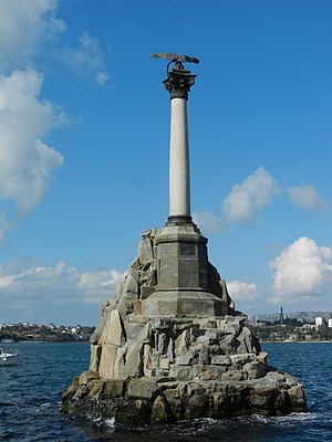
Monument to the Sunken Ships
Monument in Sevastopol, Crimea
Distance: Approx. 1150 meters
Latitude and longitude: 44.618388,33.524263
The Monument to the Sunken Ships (Russian: Памятник затопленным кораблям, romanized: Pamyatnik zatoplennym korablyam; Ukrainian: Пам'ятник затопленим кораблям, romanized: Pamiatnyk zatoplenym korabliam) is the symbol of the city of Sevastopol, on the disputed Crimean peninsula. Located in Sevastopol Bay, it was designed by Amandus Adamson and built by Valentin Feldmann in 1905.

Mikhail Kroshitsky Sevastopol Art Museum
Art museum in Sevastopol, Crimea
Distance: Approx. 806 meters
Latitude and longitude: 44.61368,33.52236
The M. Kroshitsky Sevastopol Art Museum (Ukrainian: Севастопольський художній музей імені М. П. Крошицького) is an art museum located in the Crimean city of Sevastopol. The museum is located in the centre of the city, in a "remarkable" four-story mansion with a "magnificently decorated facade," built in the late 19th century by the "personal honorary citizen of Sevastopol" merchant Semyon Gavalov. After the formation of the Crimean Autonomous Soviet Socialist Republic in 1921, the museum was opened in November 1927 “for the broadest masses of the people.” It was renamed in 1991, in honour of Mikhail Kroshitsky, museum director from 1939 to 1958.
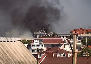
Missile strike on the Black Sea Fleet headquarters
Ukrainian military airstrike in Crimea
Distance: Approx. 649 meters
Latitude and longitude: 44.61277778,33.52388889
On 22 September 2023, several Ukrainian Storm Shadow/SCALP cruise missiles penetrated Russian air defenses and struck the headquarters of the Black Sea Fleet in occupied Sevastopol, Crimea. The strike was part of the war resulting from the ongoing Russian invasion of Ukraine, and was referred to as Operation Crab Trap (Ukrainian: Операція «Крабова пастка», romanized: Operatsiia "Krabova pastka") by Lieutenant General Kyrylo Budanov, the head of the Main Directorate of Intelligence (HUR).
Weather in this IP's area
broken clouds
16 Celsius
15 Celsius
16 Celsius
16 Celsius
1017 hPa
46 %
1017 hPa
1017 hPa
10000 meters
4.79 m/s
6.9 m/s
55 degree
64 %
06:30:49
18:47:46