Country:
 Portugal
Region:
City:
Latitude and Longitude:
Time Zone:
Postal Code:
IP information under different IP Channel
ip-api
Country
Region
City
ASN
Time Zone
ISP
Blacklist
Proxy
Latitude
Longitude
Postal
Route
IPinfo
Country
Region
City
ASN
Time Zone
ISP
Blacklist
Proxy
Latitude
Longitude
Postal
Route
MaxMind
Country
Region
City
ASN
Time Zone
ISP
Blacklist
Proxy
Latitude
Longitude
Postal
Route
Luminati
Country
PTRegion
11
City
lisbon
ASN
Time Zone
Europe/Lisbon
ISP
Fundacao para a Ciencia e a Tecnologia, I.P.
Latitude
Longitude
Postal
db-ip
Country
Region
City
ASN
Time Zone
ISP
Blacklist
Proxy
Latitude
Longitude
Postal
Route
ipdata
Country
Region
City
ASN
Time Zone
ISP
Blacklist
Proxy
Latitude
Longitude
Postal
Route
Popular places and events near this IP address
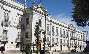
Instituto Superior Técnico
Public school of engineering and technology in Lisbon, Portugal
Distance: Approx. 646 meters
Latitude and longitude: 38.73666667,-9.13888889
The Instituto Superior Técnico (IST, also known as Técnico, and stylized TÉCNICO LISBOA; Higher Technical InstituteEnglish: Higher Technical Institute) is the school of engineering and technology of the University of Lisbon. It was founded as an autonomous school in 1911, and was integrated into the Technical University of Lisbon (now part of the University of Lisbon) in 1930. IST is the largest school of engineering in Portugal by number of enrolled students, faculty size, scientific production and patents.
Penha de França
Civil parish in Lisbon, Portugal
Distance: Approx. 591 meters
Latitude and longitude: 38.729,-9.131
Penha de França (Portuguese pronunciation: [ˈpɐɲɐ ðɨ ˈfɾɐ̃sɐ]) is a freguesia (civil parish) and typical quarter of Lisbon, the capital city of Portugal. Located in the historic center of Lisbon, Penha de França is north of São Vicente, east of Arroios, south of Areeiro, and west of Beato. The population in 2021 was 28,475.
Instituto de Plasmas e Fusão Nuclear
Distance: Approx. 778 meters
Latitude and longitude: 38.7373501,-9.1410516
Instituto de Plasmas e Fusão Nuclear (IPFN) (Institute for Plasmas and Nuclear Fusion) is a research unit of Instituto Superior Técnico (IST), Lisbon, and a leading Portuguese institution in physics research. IPFN has the status of Associate Laboratory in the thematic areas of controlled nuclear fusion, plasma technologies and intense lasers, granted by the Portuguese Foundation for Science and Technology. IPFN was formally created in January 2008, as a result of the merging between the former research units Center for Nuclear Fusion and Center for Plasma Physics.

Camões Secondary School
Secondary School in Lisbon, Portugal
Distance: Approx. 536 meters
Latitude and longitude: 38.73022222,-9.14338889
The Secondary School Luís de Camões (Portuguese: Escola Secundária Luís de Camões) is a secondary school located in the civil parish of Arroios, in the municipality and Portuguese capital of Lisbon, classified as a Monumento de Interesse Público (Monument of Public Interest) in 2012. Founded in 1902 and named after Portuguese poet Luís de Camões, it is one of the largest and most prestigious secondary schools in Lisbon, known for the many important Portuguese public figures who have attended it, including novelist António Lobo Antunes, current UN Secretary-General António Guterres and former President of the European Commission José Manuel Barroso.
INESC-ID
Research institution in Lisbon, Portugal
Distance: Approx. 664 meters
Latitude and longitude: 38.7362113,-9.1410125
The Instituto de Engenharia de Sistemas e Computadores - Investigação e Desenvolvimento (INESC-ID, English: Institute of Systems and Computer Engineering - Research and Development) is a non-profit, privately owned institution of public interest, in Lisbon, Portugal, dedicated to advanced research and development in the domains of electronics, energy, telecommunications and information technologies. It was awarded the status of Associate Laboratory of the Portuguese Ministry for Science and Technology in 2005.

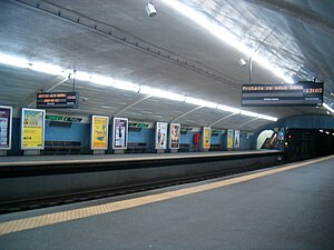
Alameda Station
Metro station in Lisbon, Portugal
Distance: Approx. 697 meters
Latitude and longitude: 38.73666667,-9.13388889
Alameda is a station on the Green and Red Lines of the Lisbon Metro. The station is located on Avenida Almirante Reis at Alameda Dom Afonso Henriques, east of the Instituto Superior Técnico.

Arroios
Civil parish in Lisbon, Portugal
Distance: Approx. 231 meters
Latitude and longitude: 38.729,-9.138
Arroios (Portuguese pronunciation: [ɐˈʁojuʃ]) is a freguesia (civil parish) and district of Lisbon, the capital of Portugal. Located in central Lisbon, Arroios is north of Santa Maria Maior and São Vicente, east of Santo António, south of Avenidas Novas and Areeiro, and west of Penha de França. The population in 2011 was 31,653.
Arroios Station
Metro station in Lisbon, Portugal
Distance: Approx. 370 meters
Latitude and longitude: 38.7335,-9.1345
Arroios is a station on the Green Line of the Lisbon Metro. The station is located in the Almirante Reis Avenue, in Arroios neighbourhood.

Anjos Station
Metro station in Lisbon, Portugal
Distance: Approx. 550 meters
Latitude and longitude: 38.7264,-9.135
Anjos is a station on the Green Line of the Lisbon Metro. The station is located on the Almirante Reis Avenue, close to Monte Agudo. It takes its name from the historic Anjos parish.

Igreja dos Anjos
Distance: Approx. 763 meters
Latitude and longitude: 38.72450278,-9.13451944
The Church of Our Lady of the Angels (Portuguese: Igreja de Nossa Senhora dos Anjos), more commonly known simply as Igreja dos Anjos [iˈɣɾɐʒɐ ðuz ˈɐ̃ʒuʃ], is a Roman Catholic parish church located in Lisbon, Portugal.

List of ambassadors of Italy to Portugal
Distance: Approx. 788 meters
Latitude and longitude: 38.723926,-9.136987
The Italian ambassador in Lisbon is the official representative of the Government in Rome to the Government of Portugal. Since 1860 the governments in Rome and Lisbon maintain diplomatic relations.

Hospital de Dona Estefânia
Hospital in Lisbon, Portugal
Distance: Approx. 367 meters
Latitude and longitude: 38.7281,-9.1393
Hospital de Dona Estefânia (European Portuguese pronunciation: [ɔʃpiˈtal dɨ ˈðonɐ (ɨ)ʃteˈfɐnjɐ]; "Queen Stephanie's Hospital") is a public Central Hospital serving the Greater Lisbon, Portugal, area as part of the Central Lisbon University Hospital Centre (CHULC), a state-owned enterprise. Established in 1877 in memory of Queen Stephanie, this was the first Portuguese hospital specifically dedicated to the healthcare of children, and it remains a national reference in pediatric specialties, both medical and surgical. It serves the south of the country and Insular Portugal.
Weather in this IP's area
clear sky
33 Celsius
30 Celsius
31 Celsius
33 Celsius
1010 hPa
20 %
1010 hPa
1003 hPa
10000 meters
5.81 m/s
8.49 m/s
346 degree
07:19:13
19:43:35