Country:
 Germany
Region:
City:
Latitude and Longitude:
Time Zone:
Postal Code:
IP information under different IP Channel
ip-api
Country
Region
City
ASN
Time Zone
ISP
Blacklist
Proxy
Latitude
Longitude
Postal
Route
IPinfo
Country
Region
City
ASN
Time Zone
ISP
Blacklist
Proxy
Latitude
Longitude
Postal
Route
MaxMind
Country
Region
City
ASN
Time Zone
ISP
Blacklist
Proxy
Latitude
Longitude
Postal
Route
Luminati
Country
DEASN
Time Zone
Europe/Berlin
ISP
COLT Technology Services Group Limited
Latitude
Longitude
Postal
db-ip
Country
Region
City
ASN
Time Zone
ISP
Blacklist
Proxy
Latitude
Longitude
Postal
Route
ipdata
Country
Region
City
ASN
Time Zone
ISP
Blacklist
Proxy
Latitude
Longitude
Postal
Route
Popular places and events near this IP address

Scheunenviertel
Sub-neighborhood
Distance: Approx. 367 meters
Latitude and longitude: 52.52611111,13.41
(German: "Barn Quarter") is a neighborhood of Mitte in the centre of Berlin. It is situated to the north of the medieval Altberlin area, east of the Rosenthaler Straße and Hackescher Markt. Until the Second World War it was regarded as a slum district and had a substantial Jewish population with a high proportion of migrants from Eastern Europe.

Rosenstrasse protest
1943 street protest in Nazi Germany
Distance: Approx. 245 meters
Latitude and longitude: 52.52180556,13.40444444
The Rosenstrasse protest is considered to be a significant event in German history as it is the only mass public demonstration by Germans in the Third Reich against the deportation of Jews. The protest on Rosenstraße ("Roses street") took place in Berlin during February and March 1943. This demonstration was initiated and sustained by the non-Jewish wives and relatives of Jewish men and Mischlinge, (those of mixed Jewish and Aryan heritage).

Karl-Liebknecht-Straße
Major street in the Berlin Mitte district
Distance: Approx. 265 meters
Latitude and longitude: 52.52138889,13.40722222
Karl-Liebknecht-Straße is a major street in the central Mitte district of the German capital Berlin. It is named after Karl Liebknecht (1871–1919), one of the founders of the Communist Party of Germany. The street connects the Unter den Linden boulevard with the Prenzlauer Allee arterial road leading to the northern city limits.

St. Mary's Church, Berlin
Church in Berlin, Germany
Distance: Approx. 351 meters
Latitude and longitude: 52.52055556,13.40666667
St. Mary's Church, known in German as the Marienkirche or St.-Marien-Kirche, is a church in Berlin, Germany. It is located on Karl-Liebknecht-Straße (formerly Kaiser-Wilhelm-Straße) in central Berlin, near Alexanderplatz.

Weinmeisterstraße (Berlin U-Bahn)
Station of the Berlin U-Bahn
Distance: Approx. 169 meters
Latitude and longitude: 52.525,13.405
Weinmeisterstraße is a Berlin U-Bahn station located on the U8. It was built in 1930 (1930) by Alexander Grenander and shortly closed during World War II. During the Berlin Wall (from 1961) the station was closed by the East German government, later on top of the entrances apartments were built. When it was reopened on 1 July 1990, there were some difficulties to open them again, but so far minor cleanup is needed.

Hackescher Markt
Public square in Berlin
Distance: Approx. 242 meters
Latitude and longitude: 52.52333333,13.40277778
Hackescher Markt ("Hacke's Market") is a square in the central Mitte locality of Berlin, Germany, situated at the eastern end of Oranienburger Strasse. It is an important transport hub and a starting point for the city's nightlife.

Berlin Hackescher Markt station
Berlin S-Bahn Station
Distance: Approx. 301 meters
Latitude and longitude: 52.523,13.402
Berlin Hackescher Markt is a railway station in the Mitte district of Berlin, Germany. It is named after the adjacent Hackescher Markt square.

1757 raid on Berlin
1757 skirmish
Distance: Approx. 347 meters
Latitude and longitude: 52.523405,13.4114
The 1757 raid on Berlin took place during the Third Silesian War (part of the Seven Years' War). Cavalrymen of the Holy Roman Empire attacked and briefly occupied Berlin, the capital of Prussia.

Hackesche Höfe
Courtyard complex in Berlin
Distance: Approx. 281 meters
Latitude and longitude: 52.52416667,13.40222222
The Hackesche Höfe (English: Hacke's Courtyards) is a notable courtyard complex situated adjacent to the Hackescher Markt in the centre of Berlin. The complex consists of eight interconnected courtyards, accessed through a main arched entrance at number 40 Rosenthaler Straße. The complex was designed in the Jugendstil (or Art Nouveau) style by August Endell, and the first courtyard is adorned with a magnificent facade of polychrome glazed brick.
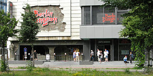
Berlin Dungeon
Distance: Approx. 319 meters
Latitude and longitude: 52.52141,13.40348
Berlin Dungeon is a tourist attraction from a chain including the London Dungeon and Hamburg Dungeon. It provides a journey through Berlin's dark history in an actor led, interactive experience. There are both German and English shows and the actors speak German and English.

Old Synagogue (Berlin)
Former synagogue in Berlin, Germany
Distance: Approx. 307 meters
Latitude and longitude: 52.5211,13.4048
The Old Synagogue (‹See Tfd›German: Alte Synagoge) was a Jewish congregation and synagogue, that was located at Heidereutergasse 4, in Marienviertel, in the present-day Mitte district of Berlin, Germany. Designed and built by Michael Kemmeter, the synagogue was built as a rectangular hall building. Consecrated in 1714 and remodelled in 1855, the synagogue was known as the Great Synagogue until the opening of the New Synagogue, built in the 1860s to accommodate Berlin's expanding Jewish population.
LAS Art Foundation
Distance: Approx. 320 meters
Latitude and longitude: 52.5257,13.4097
LAS Art Foundation is a forward-thinking arts organisation in Berlin, Germany. It was launched in 2019 by Jan Fischer and Bettina Kames, focussing on exploring the intersection of art, science and technology. The foundation's primary objective is to develop groundbreaking projects and experiences that envision the future and investigate topics ranging from artificial intelligence and quantum computing to ecology and biotechnology.
Weather in this IP's area
broken clouds
12 Celsius
12 Celsius
12 Celsius
13 Celsius
1014 hPa
92 %
1014 hPa
1009 hPa
10000 meters
5.81 m/s
9.39 m/s
350 degree
75 %
07:11:15
18:39:11