194.113.44.208 - IP Lookup: Free IP Address Lookup, Postal Code Lookup, IP Location Lookup, IP ASN, Public IP
Country:
 Great Britain
Region:
City:
Location:
Time Zone:
Postal Code:
ISP:
ASN:
language:
User-Agent:
Proxy IP:
Blacklist:
IP information under different IP Channel
ip-api
Country
Region
City
ASN
Time Zone
ISP
Blacklist
Proxy
Latitude
Longitude
Postal
Route
db-ip
Country
Region
City
ASN
Time Zone
ISP
Blacklist
Proxy
Latitude
Longitude
Postal
Route
IPinfo
Country
Region
City
ASN
Time Zone
ISP
Blacklist
Proxy
Latitude
Longitude
Postal
Route
IP2Location
194.113.44.208Country
gbRegion
england
City
diss
Time Zone
Europe/London
ISP
Language
User-Agent
Latitude
Longitude
Postal
ipdata
Country
Region
City
ASN
Time Zone
ISP
Blacklist
Proxy
Latitude
Longitude
Postal
Route
Popular places and events near this IP address

Diss, Norfolk
Town in Norfolk, England
Distance: Approx. 497 meters
Latitude and longitude: 52.3812,1.1079
Diss is a market town, civil parish and electoral ward in South Norfolk, England; it is near to the boundary with Suffolk. It had population of 7,572 in 2011. It lies in the valley of the River Waveney, round a mere covering 6 acres (2.4 ha) and up to 18 feet (5.5 m) deep, although there is another 51 feet (16 m) of mud.

Diss Town F.C.
Association football club in England
Distance: Approx. 924 meters
Latitude and longitude: 52.38083333,1.09722222
Diss Town Football Club is a football club based in Diss, Norfolk, England. Affiliated to the Norfolk County FA, they are members of the Eastern Counties League Division One North and play at Brewers Green Lane.
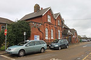
Diss railway station
Railway station in Norfolk, England
Distance: Approx. 1059 meters
Latitude and longitude: 52.374,1.124
Diss railway station is on the Great Eastern Main Line in the East of England, serving the market town of Diss, Norfolk. It is 94 miles 43 chains (152.1 km) down the line from London Liverpool Street and is situated between Stowmarket to the south and Norwich to the north. It is approximately 20 miles (32 km) south of Norwich.

Roydon, South Norfolk
Human settlement in England
Distance: Approx. 1966 meters
Latitude and longitude: 52.381,1.081
Roydon is a small village, parish and electoral ward in the county of Norfolk, England, about a mile west of Diss. It covers an area of 5.54 km2 (2.14 sq mi) and had a population of 2,358 in 981 households at the 2001 census, the population of both parish and ward increasing to 2,457 at the 2011 Census. It is mentioned in 1035 as Rygedune, and as Regadona and Regheduna in the Domesday Book, and later in 1242 as Reydon.
Diss High School
Stand alone convertor academy in Diss, Norfolk, England
Distance: Approx. 535 meters
Latitude and longitude: 52.37993,1.11507
Diss High School is a secondary school and sixth form with academy status located in Diss, Norfolk, England. The school has approximately 931 pupils from ages 11 to 18.

Palgrave, Suffolk
Human settlement in England
Distance: Approx. 1542 meters
Latitude and longitude: 52.36298,1.10756
Palgrave is a village and civil parish in the Mid Suffolk district of Suffolk in eastern England. It is located on the south bank of the River Waveney, opposite Diss in Norfolk and adjacent to the Great Eastern Main Line. Palgrave has a small primary school, with St Peter’s Church located opposite, and is situated approximately 1 mile from Diss.

Button's Mill, Diss
Windmill in Diss, Norfolk, England
Distance: Approx. 975 meters
Latitude and longitude: 52.36995,1.1180352
Jay's Mill, Button's Mill or Victoria Road Mill is a tower mill at Diss, Norfolk, England which has been truncated and converted to residential accommodation.

St Andrew's Church, Frenze
Church in Norfolk, England
Distance: Approx. 1873 meters
Latitude and longitude: 52.3802,1.1361
St Andrew's Church is a redundant Anglican church in the civil parish of Scole, Norfolk, England. It is recorded in the National Heritage List for England as a designated Grade I listed building, and is under the care of the Churches Conservation Trust. The church stands in an isolated position adjacent to Frenze Hall, near to the long-distance footpath, Boudica's Way (Boudicca Way), 1 mile (1.6 km) northeast of Diss.

Roydon Fen
Nature reserve with fen and wet woodland
Distance: Approx. 1650 meters
Latitude and longitude: 52.375,1.085
Roydon Fen is a 17.2 hectare Local Nature Reserve south of Roydon, on the western outskirts of Diss in Norfolk. It is owned by South Norfolk District Council and managed by the Suffolk Wildlife Trust. This site was taken over by wet woodland in the twentieth century, but the Trust has restored the eastern end to fen by mowing, and it has many typical fen plants such as marsh helleborine, marsh fragrant orchid and sawsedge.

Gypsy Camp Meadows, Thrandeston
Protected area in Suffolk, England
Distance: Approx. 2706 meters
Latitude and longitude: 52.353,1.101
Gypsy Camp Meadows, Thrandeston is a 2.4-hectare (5.9-acre) biological Site of Special Scientific Interest north of Thrandeston in Suffolk. These wet meadows on poorly drained boulder clay have a rich variety of flora, and drainage ditches, areas of drier grassland and hedges add to the diversity. Plants include early purple orchid, ragged robin, zig-zag clover and water avens.

Corn Hall, Diss
Commercial building in Diss, Norfolk, England
Distance: Approx. 157 meters
Latitude and longitude: 52.3776,1.1072
The Corn Hall is a commercial building in St Nicholas Street, Diss, Norfolk, England. The structure, which is now used as an arts centre, is a Grade II listed building.

Diss Town Hall
Municipal building in Diss, Norfolk, England
Distance: Approx. 94 meters
Latitude and longitude: 52.3771,1.1078
Diss Town Hall is a municipal building on Market Hill in Diss, Norfolk, a town in England.The building, which currently accommodates the offices of Diss Town Council, is a Grade II listed building.
Weather in this IP's area
overcast clouds
3 Celsius
-2 Celsius
2 Celsius
3 Celsius
1019 hPa
95 %
1019 hPa
1013 hPa
17 meters
4.99 m/s
9.95 m/s
36 degree
100 %