Country:
Region:
City:
Latitude and Longitude:
Time Zone:
Postal Code:
IP information under different IP Channel
ip-api
Country
Region
City
ASN
Time Zone
ISP
Blacklist
Proxy
Latitude
Longitude
Postal
Route
Luminati
Country
ASN
Time Zone
Europe/Vienna
ISP
eww ag
Latitude
Longitude
Postal
IPinfo
Country
Region
City
ASN
Time Zone
ISP
Blacklist
Proxy
Latitude
Longitude
Postal
Route
db-ip
Country
Region
City
ASN
Time Zone
ISP
Blacklist
Proxy
Latitude
Longitude
Postal
Route
ipdata
Country
Region
City
ASN
Time Zone
ISP
Blacklist
Proxy
Latitude
Longitude
Postal
Route
Popular places and events near this IP address

Steyr
Statutory city in Upper Austria, Austria
Distance: Approx. 5269 meters
Latitude and longitude: 48.03333333,14.41666667
Steyr (German: [ˈʃtaɪɐ] ; Central Bavarian: Steia) is a statutory city, located in the Austrian federal state of Upper Austria. It is the administrative capital, though not part of Steyr-Land District. Steyr is Austria's 12th most populated town and the 3rd largest city in Upper Austria.

Bummerlhaus
Distance: Approx. 4661 meters
Latitude and longitude: 48.03888889,14.41944444
The Bummerlhaus is a gothic building in Steyr, Austria. It is the best preserved late Gothic mansion in Steyr, and is one of the finest medieval secular buildings in Austria. The oldest part of the building dates from the thirteenth century, and it is first mentioned in documents dating from 1450.

Gleink Abbey
Former Benedictine monastery in Steyr, Austria (12c. - 1784)
Distance: Approx. 3435 meters
Latitude and longitude: 48.0675,14.41472222
Gleink Abbey (Stift or Kloster Gleink) was a Benedictine monastery located in the town of Steyr in Austria. The monastery was founded in the early 12th century by Arnhalm I of Glunich with monks from Garsten Abbey. Upon its dissolution in 1784, the abbey church became the church for the parish.

Vorwärts Stadium
Multipurpose stadium in Steyr, Austria
Distance: Approx. 5205 meters
Latitude and longitude: 48.03764167,14.41078611
Vorwärts Stadium, also known as the LIWEST Arena, is a multi-purpose stadium in Steyr, Austria. It is used mostly for football matches and is the home ground of SK Vorwärts Steyr. The stadium holds 6,000 people and was built in 1986.

Steyr (river)
River in Upper Austria, Austria
Distance: Approx. 4243 meters
Latitude and longitude: 48.0424,14.422
The Steyr (German: [ˈʃtaɪɐ] ) is a river in Upper Austria. Its length is approx. 68 km (42 mi).

Behamberg
Municipality in Lower Austria, Austria
Distance: Approx. 5998 meters
Latitude and longitude: 48.01666667,14.46666667
Behamberg is a town in the district of Amstetten in Lower Austria in Austria.

Haidershofen
Municipality in Lower Austria, Austria
Distance: Approx. 2078 meters
Latitude and longitude: 48.06666667,14.43333333
Haidershofen is a town located in Austria. The town is within the district of Amstetten, located in Lower Austria.
Steyr-Münichholz subcamp
Distance: Approx. 1790 meters
Latitude and longitude: 48.05638889,14.44888889
The Steyr-Münichholz concentration camp was one in a number of subcamps of the Mauthausen-Gusen concentration camp in Upper Austria. Inmates were drawn from the main camp, in order to exploit their labor for producing arms in Steyr-Daimler-Puch corporation factories, and to build air-raid bunkers in the town of Steyr. Roughly 300 Mauthausen-Gusen inmates had been doing construction work at the Steyr facilities since spring 1941, being transferred back and forth between Mauthausen and Steyr on a daily basis.

Dietach
Place in Upper Austria, Austria
Distance: Approx. 4092 meters
Latitude and longitude: 48.09194444,14.41611111
Dietach is a municipality in the district of Steyr-Land in the Austrian state of Upper Austria.

Sankt Ulrich bei Steyr
Place in Upper Austria, Austria
Distance: Approx. 6248 meters
Latitude and longitude: 48.0225,14.41694444
Sankt Ulrich bei Steyr is a municipality in the district of Steyr-Land in the Austrian state of Upper Austria.
Steyr Valley Railway
Distance: Approx. 6484 meters
Latitude and longitude: 48.04027778,14.38611111
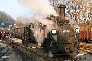
The Steyr Valley Railway (German: Steyrtalbahn) was a 760 mm (2 ft 5+15⁄16 in) narrow gauge railway in Upper Austria, which ran along the valley of the River Steyr from Garsten through Steyr, Grünburg and Molln to Klaus, with a branchline to Sierning and Bad Hall. A section of the line has been retained as a museum railway.
Celestine Church, Steyr
Church in Steyr, Upper Austria
Distance: Approx. 4613 meters
Latitude and longitude: 48.0401,14.4184
The Celestine Church, Steyr, also the Old Town Theatre (German: Cölestinerinnen-Kirche Steyr; Altes Stadttheater), is a former monastic church of the Celestine nuns in the town of Steyr in Upper Austria. The building, which is a protected historical monument, after conversion to a theatre in the 1790s, is now used as a music school and performance space.
Weather in this IP's area
clear sky
2 Celsius
2 Celsius
0 Celsius
2 Celsius
1028 hPa
99 %
1028 hPa
991 hPa
10000 meters
0.25 m/s
0.42 m/s
149 degree
07:01:32
16:30:47

