194.110.62.247 - IP Lookup: Free IP Address Lookup, Postal Code Lookup, IP Location Lookup, IP ASN, Public IP
Country:
 Finland
Region:
City:
Location:
Time Zone:
Postal Code:
ISP:
ASN:
language:
User-Agent:
Proxy IP:
Blacklist:
IP information under different IP Channel
ip-api
Country
Region
City
ASN
Time Zone
ISP
Blacklist
Proxy
Latitude
Longitude
Postal
Route
db-ip
Country
Region
City
ASN
Time Zone
ISP
Blacklist
Proxy
Latitude
Longitude
Postal
Route
IPinfo
Country
Region
City
ASN
Time Zone
ISP
Blacklist
Proxy
Latitude
Longitude
Postal
Route
IP2Location
194.110.62.247Country
fiRegion
lappi
City
kemi
Time Zone
Europe/Helsinki
ISP
Language
User-Agent
Latitude
Longitude
Postal
ipdata
Country
Region
City
ASN
Time Zone
ISP
Blacklist
Proxy
Latitude
Longitude
Postal
Route
Popular places and events near this IP address

Kemi
Town in Lapland, Finland
Distance: Approx. 32 meters
Latitude and longitude: 65.73611111,24.56361111
Kemi (Finnish: [ˈkemi]; Northern Sami: Giepma [ˈkie̯pma]; Inari Sami: Kiemâ; Skolt Sami: Ǩeeʹmm) is a town and municipality of Finland. It is located very near the city of Tornio and the Swedish border. The distance to Oulu is 105 kilometres (65 mi) to the south and to Rovaniemi is 117 kilometres (73 mi) to the northeast.

Keminmaa
Municipality in Lapland, Finland
Distance: Approx. 7108 meters
Latitude and longitude: 65.8,24.55
Keminmaa (Finnish: [ˈkeminˌmɑː]; until 1979 Kemin maalaiskunta; Inari Sami: Kiemâeennâm; Skolt Sami: Ǩeeʹmmjânnam) is a municipality of Finland. It is located near the towns of Kemi and Tornio in the Lapland region. The municipality has a population of 7,604 (31 December 2024) and covers an area of 647.24 square kilometres (249.90 sq mi) of which 20.73 km2 (8.00 sq mi) is water.
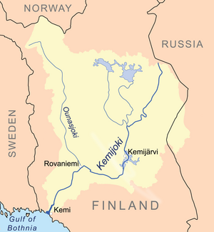
Kemijoki
Distance: Approx. 6404 meters
Latitude and longitude: 65.77,24.45
The Kemijoki or Kemi River (Swedish: Kemi älv, Northern Sami: Giemajohka), with its 550 km (340 mi) length, is the longest river in Finland. It runs south through the towns of Kemijärvi and Rovaniemi before reaching the Gulf of Bothnia at Kemi. At Rovaniemi the Ounasjoki river merges with the Kemijoki.

SnowCastle of Kemi
Distance: Approx. 1169 meters
Latitude and longitude: 65.7261,24.5687
The SnowCastle of Kemi (Finnish: Kemin lumilinna) is the biggest snow fort in the world. It is rebuilt every winter with a different architecture in Kemi, Finland. In 1996, the first snow castle drew 300,000 visitors.

Kemi Church
Church in Kemi, Finland
Distance: Approx. 466 meters
Latitude and longitude: 65.73222222,24.56305556
Kemi Church is a Finnish Evangelical Lutheran church of the Diocese of Oulu. The church is located in the centre of the town of Kemi in Northern Finland. The Gothic Revival building was designed by architect Josef Stenbäck and it was completed in 1902.

Kemi-Tornio Airport
Airport in Kemi, Finland
Distance: Approx. 4857 meters
Latitude and longitude: 65.77916667,24.58472222
Kemi-Tornio Airport (IATA: KEM, ICAO: EFKE; Finnish: Kemi-Tornion lentoasema; Swedish: Kemi-Torneå flygplats) is an airport in Kemi, Finland. The airport is located near the district of Lautiosaari, east of the Kemijoki (Kemi River), 6 kilometres (3.7 mi) north of Kemi city centre and 18 kilometres (11 mi) east of Tornio city centre. The airport is owned and operated by Finavia.
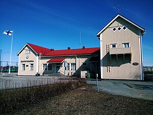
Kemi railway station
Railway station in Kemi, Finland
Distance: Approx. 471 meters
Latitude and longitude: 65.737227,24.573798
Kemi railway station (Finnish: Kemin rautatieasema) is located in the town of Kemi in the Lapland Region of Finland. It is operated by VR. The distance to the Helsinki Central railway station, via Haapamäki and Oulu stations is 858.3 kilometres. The station lies between the Kemi centre and Finnish national road 4, near the town centre services.

Jokisuu
Village in Lapland, Finland
Distance: Approx. 6184 meters
Latitude and longitude: 65.787757,24.512103
Jokisuu is a village in the municipality of Keminmaa in Lapland in north-western Finland.
Laurila
Village in Lapland, Finland
Distance: Approx. 7215 meters
Latitude and longitude: 65.8,24.53333333
Laurila is a village in the municipality of Keminmaa in Lapland in north-western Finland.
Lautiosaari
Village in Finland
Distance: Approx. 7137 meters
Latitude and longitude: 65.8,24.58333333
Lautiosaari is a village in the municipality of Keminmaa in Lapland in north-western Finland.

Eastern Lapland
Sub-region in Lapland, Finland
Distance: Approx. 7289 meters
Latitude and longitude: 65.8014,24.5444
Eastern Lapland is a subdivision of Finnish Lapland and one of the sub-regions of Finland since 2009. Eastern Lapland lies along the Russian border in northern Finland. As of 2019, it has a population of 15,808, a decrease of 31% since 2000; it is a rural and sparsely populated area.

Kemi-Tornio sub-region
Sub-region in Lapland, Finland
Distance: Approx. 7289 meters
Latitude and longitude: 65.8014,24.5444
Kemi-Tornio sub-region is a subdivision of Finnish Lapland and, since 2009, one of the sub-regions of Finland.
Weather in this IP's area
overcast clouds
-1 Celsius
-5 Celsius
-1 Celsius
-1 Celsius
1019 hPa
93 %
1019 hPa
1017 hPa
10000 meters
3.6 m/s
20 degree
100 %