Country:
 Austria
Region:
City:
Latitude and Longitude:
Time Zone:
Postal Code:
IP information under different IP Channel
ip-api
Country
Region
City
ASN
Time Zone
ISP
Blacklist
Proxy
Latitude
Longitude
Postal
Route
IPinfo
Country
Region
City
ASN
Time Zone
ISP
Blacklist
Proxy
Latitude
Longitude
Postal
Route
MaxMind
Country
Region
City
ASN
Time Zone
ISP
Blacklist
Proxy
Latitude
Longitude
Postal
Route
Luminati
Country
ATRegion
1
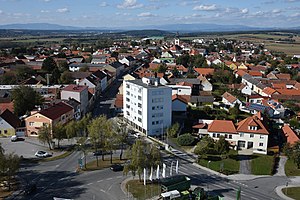
City
oberwart
ASN
Time Zone
Europe/Vienna
ISP
kabelplus GmbH
Latitude
Longitude
Postal
db-ip
Country
Region
City
ASN
Time Zone
ISP
Blacklist
Proxy
Latitude
Longitude
Postal
Route
ipdata
Country
Region
City
ASN
Time Zone
ISP
Blacklist
Proxy
Latitude
Longitude
Postal
Route
Popular places and events near this IP address

Badersdorf
Place in Burgenland, Austria
Distance: Approx. 6131 meters
Latitude and longitude: 47.2,16.36666667
Badersdorf (Hungarian: Pöszöny, Croatian: Pesem) is a municipality in Burgenland in the district of Oberwart in Austria.
Großpetersdorf
Place in Burgenland, Austria
Distance: Approx. 1281 meters
Latitude and longitude: 47.23333333,16.31666667
Großpetersdorf (Hungarian: Nagyszentmihály) is a municipality in Burgenland in the district of Oberwart in Austria.

Hannersdorf
Place in Burgenland, Austria
Distance: Approx. 5002 meters
Latitude and longitude: 47.23333333,16.38333333
Hannersdorf (Hungarian: Sámfalva) is a municipality in Burgenland in the district of Oberwart in Austria.
Unterwart
Place in Burgenland, Austria
Distance: Approx. 6940 meters
Latitude and longitude: 47.26666667,16.23333333
Unterwart or Alsóőr (German: Unterwart; Hungarian: Alsóőr; Croatian: Dolnja Borta) is a village in Burgenland, Austria, in the district of Oberwart (Hun: Felsőőr). The village lies on the banks of the Pinka river, and it had a population of 964 in 2001 (without Eisenzicken only 724). Unterwart is one of only two settlements in Austria with an ethnic Hungarian majority.

Eisenzicken
Distance: Approx. 5770 meters
Latitude and longitude: 47.275914,16.25832
Eisenzicken (Hungarian: Németciklény, Vasverőszék or Vasszék, Croatian: Nimski Cikljin) is a small community in Burgenland, Austria that belongs to the neighbouring village of Unterwart (Hun.: Alsóőr). It had a population of 240 in 2001.
Siget in der Wart
Distance: Approx. 3656 meters
Latitude and longitude: 47.26666667,16.28333333
Siget in der Wart or Őrisziget (German: Siget in der Wart; Hungarian: Őrisziget) is a small village in Burgenland, Austria, in the district of Oberwart (Hun: Felsőőr). The village lies on the banks of the Zicken Bach (Szék-patak) and administratively belongs to the neighbouring town of Rotenturm an der Pinka (Hun: Vasvörösvár). According to the 2001 census it had a population of 274.

Rotenturm an der Pinka
Place in Burgenland, Austria
Distance: Approx. 5270 meters
Latitude and longitude: 47.25,16.25
Rotenturm an der Pinka (Hungarian: Vasvörösvár, Croatian: Verešvar) is a municipality in the Austrian state of Burgenland on the banks of the Pinka River. Administratively the village belongs to the district of Oberwart. Rotenturm is almost merged with the neighbouring Unterwart.
Jabing
Place in Burgenland, Austria
Distance: Approx. 4174 meters
Latitude and longitude: 47.23333333,16.26666667
Jabing (Hungarian: Vasjobbágyi) is a town in the district of Oberwart in the Austrian state of Burgenland.
Mischendorf
Place in Burgenland, Austria
Distance: Approx. 4980 meters
Latitude and longitude: 47.2,16.31666667
Mischendorf is a town in the district of Oberwart in the Austrian state of Burgenland.

Weiden bei Rechnitz
Place in Burgenland, Austria
Distance: Approx. 6578 meters
Latitude and longitude: 47.3,16.35
Weiden bei Rechnitz (Croatian: Bandol, Hungarian: Bándol) is a town in the district of Oberwart in the Austrian state of Burgenland.

Neuhaus in der Wart
Distance: Approx. 5255 meters
Latitude and longitude: 47.217,16.263
Neuhaus in der Wart (formerly Krobotdorf or Kroatdorf, Croatian: Dobra, Hungarian: Őridobra ) is a Katastralgemeinde of the municipality Mischendorf in southern Burgenland, Austria. It is part of the district Oberwart.
Miedlingsdorf
Distance: Approx. 2224 meters
Latitude and longitude: 47.26467,16.318603
Miedlingsdorf is an Austrian village in the district of Oberwart in the state of Burgenland.
Weather in this IP's area
clear sky
14 Celsius
14 Celsius
12 Celsius
14 Celsius
1020 hPa
89 %
1020 hPa
988 hPa
10000 meters
2.81 m/s
5.1 m/s
4 degree
5 %
06:37:49
18:59:09