Country:
 Austria
Region:
City:
Latitude and Longitude:
Time Zone:
Postal Code:
IP information under different IP Channel
ip-api
Country
Region
City
ASN
Time Zone
ISP
Blacklist
Proxy
Latitude
Longitude
Postal
Route
IPinfo
Country
Region
City
ASN
Time Zone
ISP
Blacklist
Proxy
Latitude
Longitude
Postal
Route
MaxMind
Country
Region
City
ASN
Time Zone
ISP
Blacklist
Proxy
Latitude
Longitude
Postal
Route
Luminati
Country
ATRegion
1
City
eisenstadt
ASN
Time Zone
Europe/Vienna
ISP
kabelplus GmbH
Latitude
Longitude
Postal
db-ip
Country
Region
City
ASN
Time Zone
ISP
Blacklist
Proxy
Latitude
Longitude
Postal
Route
ipdata
Country
Region
City
ASN
Time Zone
ISP
Blacklist
Proxy
Latitude
Longitude
Postal
Route
Popular places and events near this IP address
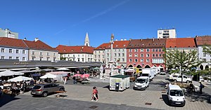
Wiener Neustadt
City in Lower Austria, Austria
Distance: Approx. 1324 meters
Latitude and longitude: 47.80888889,16.2325
Wiener Neustadt (German pronunciation: [ˈviːnɐ ˈnɔʏʃtat] ; lit. 'Newtown in the land of Vienna' [i.e. Lower Austria]; Central Bavarian: Weana Neistod, pronounced [ˈvɛɐ̯nɐ ˈnɔɪ̯ʃtɔt]) is a city located south of Vienna, in the state of Lower Austria, in northeast Austria. It is a self-governed city and the seat of the district administration of Wiener Neustadt-Land District.

Lichtenwörth
Place in Lower Austria, Austria
Distance: Approx. 1905 meters
Latitude and longitude: 47.81666667,16.26666667
Lichtenwörth (Central Bavarian: Lichtnwiad) is a market town in Austria. It is situated by the rivers Leitha and Warme Fischa. The market town has a kindergarten school, an elementary school and a high school.
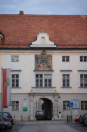
Theresian Military Academy
Military academy of the Austrian Armed Forces in Wiener Neustadt, Lower Austria
Distance: Approx. 643 meters
Latitude and longitude: 47.80972222,16.24555556
The Theresian Military Academy (German: Theresianische Militärakademie, TherMilAk) is a military academy in Austria, where the Austrian Armed Forces train their officers. Founded in 1751, the academy is located in the castle of Wiener Neustadt in Lower Austria.

Burg Wiener Neustadt
Distance: Approx. 652 meters
Latitude and longitude: 47.8099,16.2459
Burg Wiener Neustadt is a castle in the Austrian city of Wiener Neustadt in Lower Austria. It is the location of the Theresian Military Academy, which was founded in 1751. The site is 268 metres (879 ft) above sea level.

Military Ordinariate of Austria
Catholic ecclesiastical jurisdiction
Distance: Approx. 589 meters
Latitude and longitude: 47.80888889,16.24472222
The Military Ordinariate of Austria (German: Militärordinariat der Republik Österreich, Latin: Ordinariatus Militaris Austriae) is a Latin Church military ordinariate of the Catholic Church. Immediately exempt to the Holy See, it provides pastoral care to Catholics serving in the Austrian Armed Forces and their families.

Wiener Neustadt Hauptbahnhof
Railway station in Lower Austria
Distance: Approx. 1367 meters
Latitude and longitude: 47.81166667,16.23416667
Wiener Neustadt Hauptbahnhof is a railway station in Wiener Neustadt, in the federal state of Lower Austria, south of Vienna. With over 700 trains and 25,000 passengers each day, the station is the busiest in Lower Austria. An important stop on both the South railway (German: Südbahn) and the Aspangbahn, the station is also a junction for the branch lines to Gutenstein, Payerbach and Mattersburg, the Pottendorfer line to Pottendorf-Landegg, and the Vienna S-Bahn Stammstrecke (main line) to Floridsdorf.
Siege of Wiener Neustadt
Distance: Approx. 1368 meters
Latitude and longitude: 47.81666944,16.25
The siege of Wiener Neustad, part of the Austrian–Hungarian War, was an assault from January 1486 to August 1487 on the Austrian town of Wiener Neustadt. Launched by Matthias Corvinus, King of Hungary, the 18-month siege ended with the town's surrender and allowed Hungary to take control of the surrounding regions of Styria and Lower Austria. It was the last of a series of sieges, and followed Hungary's victory in the 1485 Siege of Vienna.

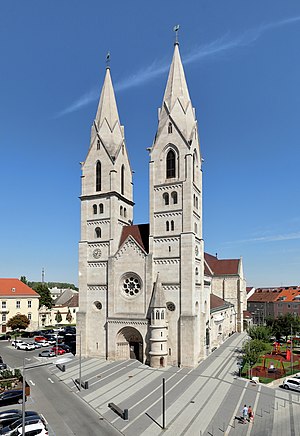
St. George's Cathedral, Wiener Neustadt
Church in Wiener Neustadt, Austria
Distance: Approx. 705 meters
Latitude and longitude: 47.8102,16.2451
St. George's Cathedral in Wiener Neustadt (German: Kathedrale St. Georg) is the cathedral of the Military Ordinariate of Austria and a minor basilica.
Wiener Neustadt Cathedral
Church in Wiener Neustadt, Austria
Distance: Approx. 1273 meters
Latitude and longitude: 47.815,16.2425
Wiener Neustadt Cathedral, or the Cathedral of the Assumption of Mary and St. Rupert (German: Wiener Neustädter Dom; Dom Mariä Himmelfahrt und Sankt Rupert), is a Catholic church located in Wiener Neustadt, Austria. Now a parish church, it was previously the cathedral of the Diocese of Wiener Neustadt from 1468 to 1785, when the diocese was suppressed.
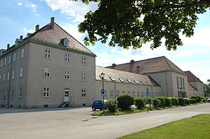
Daun Barracks
Distance: Approx. 516 meters
Latitude and longitude: 47.8084,16.2454
Daun Barracks in Wiener Neustadt in Lower Austria was built by the German Wehrmacht from 1939 to 1940 as a course building in the Academy Park south of the castle.

St. Peter an der Sperr
Distance: Approx. 1337 meters
Latitude and longitude: 47.81593,16.24388
St. Peter an der Sperr was a Dominican convent church in Wiener Neustadt in Austria. The church building is now used as an exhibition space.
Neukloster Abbey
Cistercian abbey in Wiener Neustadt, Austria
Distance: Approx. 893 meters
Latitude and longitude: 47.8123,16.2468
Neukloster Abbey was a Cistercian abbey in Wiener Neustadt, in Lower Austria. In 1881, it became a priory of Heiligenkreuz Abbey.
Weather in this IP's area
clear sky
13 Celsius
13 Celsius
12 Celsius
15 Celsius
1021 hPa
78 %
1021 hPa
989 hPa
10000 meters
1.25 m/s
1.19 m/s
282 degree
5 %
06:37:56
18:59:36