Country:
 Sweden
Region:
City:
Latitude and Longitude:
Time Zone:
Postal Code:
IP information under different IP Channel
ip-api
Country
Region
City
ASN
Time Zone
ISP
Blacklist
Proxy
Latitude
Longitude
Postal
Route
IPinfo
Country
Region
City
ASN
Time Zone
ISP
Blacklist
Proxy
Latitude
Longitude
Postal
Route
MaxMind
Country
Region
City
ASN
Time Zone
ISP
Blacklist
Proxy
Latitude
Longitude
Postal
Route
Luminati
Country
SERegion
ab
City
solna
ASN
Time Zone
Europe/Stockholm
ISP
Obenetwork AB
Latitude
Longitude
Postal
db-ip
Country
Region
City
ASN
Time Zone
ISP
Blacklist
Proxy
Latitude
Longitude
Postal
Route
ipdata
Country
Region
City
ASN
Time Zone
ISP
Blacklist
Proxy
Latitude
Longitude
Postal
Route
Popular places and events near this IP address

Solna
Municipality in Stockholm County, Sweden
Distance: Approx. 1055 meters
Latitude and longitude: 59.35,18
Solna (Swedish: Solna kommun or Solna stad, IPA: [ˈsôːlna]) is a primary settlement (or village) and a municipality in Stockholm County, Sweden, located just north of Stockholm City Centre. Its seat is located in the town of Solna, which is a part of the Stockholm urban area. Solna is one of the richest municipalities in Sweden.

Råsunda Stadium
Association football stadium in Solna, Sweden between 1937–2012
Distance: Approx. 419 meters
Latitude and longitude: 59.36277778,17.99638889
Råsunda Stadium (Swedish: [ˈrôːˌsɵnːda] ; also known as Råsunda Fotbollsstadion, Råsundastadion, Råsunda Football Stadium or just Råsunda) was the Swedish national football stadium. It was located in Solna Municipality in Stockholm and named after the district in Solna where it is located. The stadium was demolished in 2013 after being replaced by the Friends Arena.

Råsunda (district)
Urban district in Solna Municipality, Sweden
Distance: Approx. 626 meters
Latitude and longitude: 59.36472222,17.99472222
Råsunda is a district in Solna Municipality, and a suburb in the Stockholm metropolitan area with around 17,500 inhabitants. The movie industry set up in the area Filmstaden, formerly an ostrich farm, in 1919–1969 (nowadays the area has homes, offices) in western Råsunda. A large football stadium (Råsunda Stadium) stood in central Råsunda 1937–2003, on the grounds of a sports field that existed from 1910.

Hagalund
Distance: Approx. 1019 meters
Latitude and longitude: 59.36220278,18.0117
Hagalund () is a residential area and railway yard in Solna Municipality, 5 km north of central Stockholm. It is known for the blue highrise buildings "Blåkulla" (Blue Hill or Blockula) which, against a rather strong and long-lasting opinion, in the beginning of the 1970s replaced a picturesque working-class and craftsman neighbourhood built in the 1890s and portrayed by artist Olle Olsson Hagalund. There are still about half a dozen old houses preserved, a minor area called Gamla Hagalund (Old Hagalund) in the eastern part of the area.

Näckrosen metro station
Stockholm Metro station
Distance: Approx. 1030 meters
Latitude and longitude: 59.36638889,17.98361111
Näckrosen (meaning the water lily) is a station on the Stockholm metro, blue line. The station is located in Solna Municipality (northwestern end of Råsunda area), but one of the entrances is in Sundbyberg Municipality (Storskogen square). The Näckrosen station was opened on 31 August 1975 as part the first stretch of the Blue Line between T-Centralen and Hjulsta.

Huvudsta
Distance: Approx. 1196 meters
Latitude and longitude: 59.34944444,17.98555556
Huvudsta is a suburb of Stockholm in Solna Municipality, Sweden. In Huvudsta, near Vasastaden in Stockholm, stands the Karlberg Castle which was built in the 17th century. The Huvudsta metro station was opened in 1985 as part of the Blue line.

Solna centrum metro station
Stockholm Metro station
Distance: Approx. 206 meters
Latitude and longitude: 59.35997222,17.998
Solna centrum is a metro station in Solna Municipality, approximately 5 km (3.1 mi) from central Stockholm, Sweden. It is close to the Sona Centrum shopping cenrre and Strawberry Arena. It opened on 31 August 1975 as part the first stretch of the Blue Line between T-Centralen and Hjulsta.
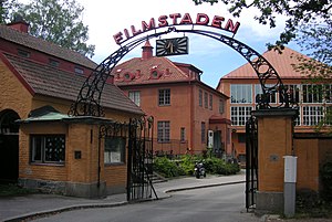
Filmstaden
Film studio in Solna, Sweden
Distance: Approx. 1148 meters
Latitude and longitude: 59.36694444,17.98166667
Filmstaden was a film studio situated in Råsunda, Solna Municipality in Stockholm, Sweden.
Solnahallen
Sports venue in Stockholm, Sweden
Distance: Approx. 336 meters
Latitude and longitude: 59.35888889,17.98888889
Solnahallen is a 2,000-capacity indoor arena located in Stockholm, Sweden. It served as the home arena for the Solna Vikings. The music video for the song "The Final Countdown" by the band Europe was shot at Solnahallen on May 26 and 27, 1986.

Råsunda IP
Football stadium in Solna, Sweden
Distance: Approx. 414 meters
Latitude and longitude: 59.36274167,17.99630833
Råsunda IP (Swedish pronunciation: [ˈrôːˌsɵnːda] ) was a football stadium in Solna, Sweden and the former home stadium for the football team AIK between 1910 and 1912. It was founded in 1910 and was demolished in 1937 when Råsunda Stadium was built on the existing site of the stadium.

Solna Gymnasium
Secondary school in Solna, Sweden
Distance: Approx. 1007 meters
Latitude and longitude: 59.3677,18.0003
Solna Gymnasium is a secondary school in Solna, Sweden, in the Stockholm metropolitan area. It was opened as the Solna Läroverk in April 1948. Crown Prince Gustaf VI Adolf of Sweden attended the opening.

Solna station
Railway station in Solna, Sweden
Distance: Approx. 1078 meters
Latitude and longitude: 59.36472222,18.01027778
Solna is a station in Solna Municipality in Stockholm for commuter trains and the Tvärbanan light rail. The lines J40 (Uppsala C-Södertälje C), J41 (Märsta-Södertälje C), J42 (Märsta-Nynäshamn) and L30 (Sickla-Solna station) stop here, as well as ten bus lines. The commuter train station opened in 1895, but was moved a 100 meters in 1903 and moved again in 1911, when the tunnel through the hill Hagalundsberget to the south was completed.
Weather in this IP's area
scattered clouds
11 Celsius
10 Celsius
10 Celsius
12 Celsius
1022 hPa
83 %
1022 hPa
1019 hPa
10000 meters
3.6 m/s
160 degree
40 %
07:38:24
17:26:48