Country:
Region:
City:
Latitude and Longitude:
Time Zone:
Postal Code:
IP information under different IP Channel
ip-api
Country
Region
City
ASN
Time Zone
ISP
Blacklist
Proxy
Latitude
Longitude
Postal
Route
Luminati
Country
Region
f
City
jonkoping
ASN
Time Zone
Europe/Stockholm
ISP
Jonkopings lans landsting
Latitude
Longitude
Postal
IPinfo
Country
Region
City
ASN
Time Zone
ISP
Blacklist
Proxy
Latitude
Longitude
Postal
Route
db-ip
Country
Region
City
ASN
Time Zone
ISP
Blacklist
Proxy
Latitude
Longitude
Postal
Route
ipdata
Country
Region
City
ASN
Time Zone
ISP
Blacklist
Proxy
Latitude
Longitude
Postal
Route
Popular places and events near this IP address

Jönköping
Place in Småland, Sweden
Distance: Approx. 2030 meters
Latitude and longitude: 57.78277778,14.16055556
Jönköping (, Swedish: [ˈjœ̂nːˌɕøːpɪŋ] ) is a city in southern Sweden with 112,766 inhabitants (2022). Jönköping is situated on the southern shore of Sweden's second largest lake, Vättern, in the province of Småland. In late 2019, Jönköping was seen as the city with best future prospects in Sweden by WSP. The city is the seat of Jönköping Municipality, which has a population of 144,699 (2022) and is Småland's most populous municipality.

Stadsparksvallen
Sports ground in Jönköping, Sweden
Distance: Approx. 1469 meters
Latitude and longitude: 57.7833,14.14186389
Stadsparksvallen, locally sometimes called Vallen, is a classic sports facility located in Jönköping, Sweden. Stadsparksvallen was inaugurated in 1902 and is located in the Jönköping City Park, atop a mountain located west of the city. It functions as home ground for football club Jönköpings Södra IF IK Tord has also played its home games here during som seasons.
Sofia Church, Jönköping
Church in Jönköping, Sweden
Distance: Approx. 2071 meters
Latitude and longitude: 57.7819,14.1597
Sofia Church (Swedish: Sofiakyrkan) is a church building in western Jönköping in Sweden. Belonging to Sofia-Järstorp Parish of the Church of Sweden, it was opened on 8 April 1888, on Octave of Easter.

Dalvik Church
Church in Dalvik, Sweden
Distance: Approx. 1002 meters
Latitude and longitude: 57.7876,14.1333
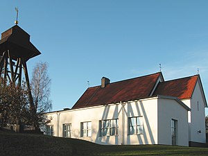
The Dalvik Church (Swedish: Dalvikskyrkan) is a church building at Dalvik in Jönköping, Sweden. It is a Swedish Evangelical Mission church belonging to the Jönköping Sofia-Järstorp Parish of the Church of Sweden, it was inaugurated on 8 February 1969 and expanded in 1985. Near the Dalvik Church is the "Kyrktuppen Kindergarten", ran by the Church of Sweden.

Bymarken Church
Church in Bymarken, Sweden
Distance: Approx. 604 meters
Latitude and longitude: 57.7911,14.1405
The Bymarken Church (Swedish: Bymarkskyrkan) is a church building at Bymarken in Jönköping, Sweden. Belonging to the Jönköping Sofia-Järstorp Parish of the Church of Sweden, it was opened in 1935.

Bäckaby Old Church
Church in Jönköping, Sweden
Distance: Approx. 1439 meters
Latitude and longitude: 57.7834,14.1391
Bäckaby Old Church (Swedish: Bäckaby gamla kyrka) was a wooden church building in Sweden. The oldest pieces were dated back to the 1320s. The old wooden church was originally in Bäckaby outside Vetlanda before being purchased by a private person and moved to the town park in Jönköping where it was reopened on 31 August 1902.
Immanuel Church, Jönköping
Church in Jönköping, Sweden
Distance: Approx. 2144 meters
Latitude and longitude: 57.7807,14.1588
The Immanuel Church (Swedish: Immanuelskyrkan) is a church building at Oxtorgsgatan in Jönköping, Sweden. Belonging to the Uniting Church in Sweden, it was built in 1975 and opened in 1976.
Cecilia Church
Church in Vilhelmsro, Sweden
Distance: Approx. 1893 meters
Latitude and longitude: 57.810833,14.154167
The Cecilia Church (Swedish: Ceciliakyrkan) a church building in Vilhelmsro outside Jönköping in Sweden. It was built in 1880–1881 as a church for the Vilhelmsro Nursing Home. It is named after Ebba Ramsay's youth friend Cecilia Willerding, and was opened in 1903 by Herman Lindström, bishop of Växjö.

Per Brahe Secondary School
Historic secondary school in Jönköping, Sweden
Distance: Approx. 2371 meters
Latitude and longitude: 57.7811,14.1656
The Per Brahe Secondary School (Swedish: Per Brahegymnasiet) is a secondary school in Jönköping, Sweden with traditions back to the 17th century. The current building was opened on 18 October 1913. Since 2007, the school has UN certification.
Jönköpings idrottshus
Distance: Approx. 1911 meters
Latitude and longitude: 57.7814,14.1536
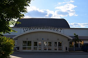
Jönköpings idrottshus, nicknamed Kåken, is a sports hall in Väster in Jönköping, Sweden. It was opened on 19 November 1939 with a handball game between GoIF Fram and IFK Kristianstad and acts as home ground for club teams like Jönköping City IBK (floorball), IK Cyrus T/S, IF Hallby (handball), Jönköpings IK (floorball) and KFUM Jönköping. Following criticism for being "too old" by the early 2000s, it was renovated and reopened on 8 September 2012.

Järstorp
Distance: Approx. 1586 meters
Latitude and longitude: 57.803,14.114
Järstorp (Swedish pronunciation: [ˈjæ̌ʂːtɔrp]) is a locality situated in Jonköping, Jönköping County, Sweden.

Match Museum
Museum about matches in Jönköping, Sweden
Distance: Approx. 1838 meters
Latitude and longitude: 57.78471,14.15967
The Match Museum (Swedish: Tändsticksmuseet) in Jönköping, Sweden is one of the few museums of matches in the world. It is located at the Tändsticksområdet, housed in Jönköping's first match factory. The museum highlights the people that worked in the factory and how the factory functioned.
Weather in this IP's area
overcast clouds
6 Celsius
6 Celsius
6 Celsius
6 Celsius
1015 hPa
100 %
1015 hPa
993 hPa
10000 meters
1.03 m/s
10 degree
100 %
07:47:18
15:48:46


