Country:
Region:
City:
Latitude and Longitude:
Time Zone:
Postal Code:
IP information under different IP Channel
ip-api
Country
Region
City
ASN
Time Zone
ISP
Blacklist
Proxy
Latitude
Longitude
Postal
Route
Luminati
Country
ASN
Time Zone
Europe/Bucharest
ISP
SC Birotec SRL
Latitude
Longitude
Postal
IPinfo
Country
Region
City
ASN
Time Zone
ISP
Blacklist
Proxy
Latitude
Longitude
Postal
Route
db-ip
Country
Region
City
ASN
Time Zone
ISP
Blacklist
Proxy
Latitude
Longitude
Postal
Route
ipdata
Country
Region
City
ASN
Time Zone
ISP
Blacklist
Proxy
Latitude
Longitude
Postal
Route
Popular places and events near this IP address

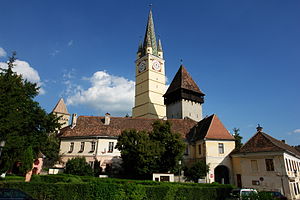
Mediaș
Municipality in Sibiu, Romania
Distance: Approx. 872 meters
Latitude and longitude: 46.16388889,24.35083333
Mediaș (Romanian pronunciation: [ˈmedi.aʃ] ; Latin: Media, German: Mediasch, Transylvanian Saxon: Medwesch/Medveš/Medwisch, Hungarian: Medgyes) is the second largest town and municipality in Sibiu County, Transylvania, central Romania.
Curciu
River in Sibiu County, Romania
Distance: Approx. 4619 meters
Latitude and longitude: 46.1813,24.4029
The Curciu is a right tributary of the river Târnava Mare in Romania. It flows into the Târnava Mare in Dârlos. Its length is 10 km (6.2 mi) and its basin size is 27 km2 (10 sq mi).
Moșna (Târnava Mare)
River in Sibiu County, Romania
Distance: Approx. 1110 meters
Latitude and longitude: 46.1718,24.3593
The Moșna is a left tributary of the river Târnava Mare in Romania. It discharges into the Târnava Mare in Mediaș. Its length is 15 km (9.3 mi) and its basin size is 59 km2 (23 sq mi).
Vorumloc
River in Sibiu County, Romania
Distance: Approx. 9220 meters
Latitude and longitude: 46.1205,24.2498
The Vorumloc (in its upper course also: Motiș) is a left tributary of the river Târnava Mare in Romania. It discharges into the Târnava Mare in Copșa Mică. Its length is 14 km (8.7 mi) and its basin size is 38 km2 (15 sq mi).

Blăjel
Commune in Sibiu, Romania
Distance: Approx. 5574 meters
Latitude and longitude: 46.21666667,24.31666667
Blăjel (German: Kleinblasendorf; Hungarian: Balázstelke) is a commune located in Sibiu County, Transylvania, Romania. It is composed of three villages: Blăjel, Păucea (Puschendorf; Pócstelke), and Romanești (Kalibák). The commune is located in the northern part of the county, 65 km (40 mi) from the county seat, Sibiu.
Bazna
Commune in Sibiu, Romania
Distance: Approx. 5770 meters
Latitude and longitude: 46.2,24.28333333
Bazna (German: Baaßen; Transylvanian Saxon dialect: Baußen; Hungarian: Bázna) is a commune located in Sibiu County, Transylvania, Romania. It is composed of three villages: Bazna, Boian (Bonnesdorf; Bonnesdref; Alsóbajom) and Velț (Wölz; Welz; Velc or Völc). The route of the Via Transilvanica long-distance trail passes through the village of Bazna.
Dârlos
Commune in Sibiu, Romania
Distance: Approx. 4470 meters
Latitude and longitude: 46.18333333,24.4
Dârlos (German: Durles; Hungarian: Darlac) is a commune located in Sibiu County, Transylvania, Romania. It is composed of three villages: Curciu (Kirtsch; Küküllőkőrös), Dârlos, and Valea Lungă (Hosszúpatak). The commune is located on the right bank of the Târnava Mare River, in the northeastern part of the county, 6 km (3.7 mi) from Mediaș.
Brateiu
Commune in Sibiu, Romania
Distance: Approx. 6167 meters
Latitude and longitude: 46.17111111,24.425
Brateiu (German: Pretai; Hungarian: Baráthely; Transylvanian Saxon dialect: Pretoa) is a commune located in Sibiu County, Transylvania, Romania. It is composed of two villages, Brateiu and Buzd, each of which has a fortified church. There is a big archaeological complex located here.

Târnava, Sibiu
Commune in Sibiu, Romania
Distance: Approx. 5190 meters
Latitude and longitude: 46.141,24.293
Târnava (German: Grossprobtsdorf; Hungarian: Nagyekemező) is a commune located in Sibiu County, Transylvania, Romania. It is composed of two villages, Colonia Târnava (Nagyekemezőtelep) and Târnava (formerly Proștea Mare). The route of the Via Transilvanica long-distance trail passes through the village of Târnava.
Media (castra)
Distance: Approx. 2325 meters
Latitude and longitude: 46.15,24.35
Media was a fort in the Roman province of Dacia.

Sala Sporturilor Mediaș
Distance: Approx. 2929 meters
Latitude and longitude: 46.14611111,24.33111111
Sala Sporturilor Mediaş ("Mediaş Sports Hall"), also known as Sala Sporturilor Vitrometan, is a multi-use indoor arena in Mediaş, Romania. The capacity of the arena is 462 seats. Starting from July 2020 the sports hall was renamed "Octavian Şerban" Sports Hall.
St. Margaret's Church, Mediaș
Distance: Approx. 782 meters
Latitude and longitude: 46.1651,24.3513
St. Margaret's Church (Romanian: Biserica Sfânta Margareta; German: Margarethenkirche) is a Lutheran church, located at 1 Piața Castelului in the historic town center of Mediaș (Mediasch), Sibiu County, in the Transylvania region of Romania. The present, late Gothic structure was built between 1437 and 1488 by the ethnic German Transylvanian Saxon community at a time when the area belonged to the Kingdom of Hungary.
Weather in this IP's area
broken clouds
8 Celsius
8 Celsius
8 Celsius
8 Celsius
1015 hPa
45 %
1015 hPa
979 hPa
10000 meters
0.49 m/s
0.44 m/s
6 degree
54 %
07:28:11
16:47:48


