Country:
 Great Britain
Region:
City:
Latitude and Longitude:
Time Zone:
Postal Code:
IP information under different IP Channel
ip-api
Country
Region
City
ASN
Time Zone
ISP
Blacklist
Proxy
Latitude
Longitude
Postal
Route
IPinfo
Country
Region
City
ASN
Time Zone
ISP
Blacklist
Proxy
Latitude
Longitude
Postal
Route
MaxMind
Country
Region
City
ASN
Time Zone
ISP
Blacklist
Proxy
Latitude
Longitude
Postal
Route
Luminati
Country
GBASN
Time Zone
Europe/London
ISP
Arelion Sweden AB
Latitude
Longitude
Postal
db-ip
Country
Region
City
ASN
Time Zone
ISP
Blacklist
Proxy
Latitude
Longitude
Postal
Route
ipdata
Country
Region
City
ASN
Time Zone
ISP
Blacklist
Proxy
Latitude
Longitude
Postal
Route
Popular places and events near this IP address

City Square, Leeds
Square in Leeds, West Yorkshire, England
Distance: Approx. 20 meters
Latitude and longitude: 53.7964,-1.5476
City Square is a paved area north of Leeds railway station at the junction of Park Row to the east and Wellington Street to the south. It is a triangular area where six roads meet: Infirmary Street and Park Row to the north, Boar Lane and Bishopsgate Street to the south-east, and Quebec Street and Wellington Street to the south-west. The only building with a direct frontage is the former General Post Office, on the north-west side.

Trinity Leeds
Shopping mall in Leeds, United Kingdom
Distance: Approx. 195 meters
Latitude and longitude: 53.797,-1.545
Trinity Leeds is a shopping and leisure centre in the city centre of Leeds, England, named after the adjacent 18th-century Holy Trinity Church. Developed by Land Securities and designed by Chapman Taylor, it opened on 21 March 2013, with over 130,000 recorded visitors on opening day. The development is in two parts: Trinity East, a new build development on the site of the former Trinity and Burton Arcades, and Trinity West, the redeveloped Leeds Shopping Plaza.
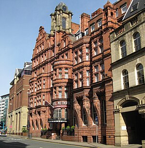
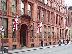
The Met Hotel
Grade II listed hotel in Leeds, West Yorkshire, England
Distance: Approx. 196 meters
Latitude and longitude: 53.79711111,-1.55063889
The Met Hotel is a Grade II listed building situated on King Street in Leeds, West Yorkshire, England. Designed by Leeds-based architects Harry Sutton Chorley and J.W. Connon, the hotel opened in 1899 as the Hotel Metropole. The Principal Hayley Group renovated the hotel in 2005, at a cost of £6 million, and changed the name to the trendier sounding 'The Met'.

Queens Hotel, Leeds
Hotel in Leeds, West Yorkshire, England
Distance: Approx. 67 meters
Latitude and longitude: 53.7959,-1.5478
The Queens Hotel is a large hotel located on City Square in Leeds, West Yorkshire, England. Built in 1937, it is an elegant Art Deco Grade II listed building and was frequented by the likes of Princess Grace of Monaco, Cary Grant and Nelson Mandela throughout its history.

4th White Cloth Hall
Distance: Approx. 196 meters
Latitude and longitude: 53.79711111,-1.55063889
The 4th White Cloth Hall was a market for the sale of undyed cloth on King Street in Leeds city centre in England. A blue plaque for the building can be found on the nearby Quebec Street. The 4th White Cloth hall was built in 1868 by the North Eastern Railway company to replace the 3rd White Cloth Hall that they had had to partly demolish in 1865 to build the impressive North Eastern Viaduct to access the New Station.

Leeds Library
Oldest surviving UK subscription library
Distance: Approx. 253 meters
Latitude and longitude: 53.7975,-1.5444
The Leeds Library is the oldest surviving subscription library of its type in the UK. It was founded in 1768, following an advertisement placed in the Leeds Intelligencer earlier that year. The first secretary was Joseph Priestley. In 1779, James Boswell wrote, "In Leeds, where one would not expect it, there is a very good public library, where strangers are treated with great civility." The library moved twice before settling in the purpose built premises on Commercial Street, Leeds on 4 July 1808.

City House
Building in Leeds, England
Distance: Approx. 191 meters
Latitude and longitude: 53.7949,-1.5468
Platform, formerly known as City House and British Railways House, is a building over Leeds railway station that was built by Taylor Woodrow in 1962. The buildings were, like many other railway buildings in the UK, designed by the later-derided architect John Poulson who also designed the nearby Leeds International Pool. Upon its construction it was famously lambasted by the poet John Betjeman, who said that the building blocked all the light out of City Square and was only a testament to money, having no architectural merit.
Quebecs Hotel, Leeds
Distance: Approx. 92 meters
Latitude and longitude: 53.796711,-1.549205
Quebecs is a Grade II listed 4-star hotel with 44 rooms located on Quebec Street in Leeds, West Yorkshire, England. Built in 1891, the building has two-storey-high stained glass windows which display the coats of arms of the principal towns of Yorkshire. Previously the building was used as the headquarters of the Leeds & County Liberal Club.

Park Row, Leeds
Street in Leeds, England
Distance: Approx. 163 meters
Latitude and longitude: 53.7979,-1.5471
Park Row is a street in Leeds city centre, West Yorkshire, England. It divides the main financial districts from the main retail districts and forms a spine between City Square and The Headrow, two of Leeds' most sought-after addresses. The street forms the western flank of the Public Transport Box, and as such is mostly reserved for buses, taxis and cyclists, especially since reconfiguration 202-2021 as part of city-centre-wide traffic infrastructure changes.
The White Rose Way
Long-distance footpath in England
Distance: Approx. 32 meters
Latitude and longitude: 53.7963,-1.5475
The White Rose Way is a 104 miles (167 km) walking trail in England from Leeds, West Yorkshire to Scarborough, North Yorkshire. It was created in 2011 by local author Paul Brown. The walk starts at the foot of the Black Prince Statue in City Square with the finish line being at the former harbour-side Tourist Information Centre in the South Bay, Scarborough (now Esposito's Ice Cream next to Ask Restaurant).

Mill Hill Chapel
Church in West Yorkshire, England
Distance: Approx. 85 meters
Latitude and longitude: 53.7967,-1.5466
Mill Hill Chapel is a Unitarian church in Leeds, West Yorkshire, England. It is a member of the General Assembly of Unitarian and Free Christian Churches, the umbrella organisation for British Unitarians. The building, which stands in the centre of the city on City Square, was granted Grade II* listed status in 1963.

Majestic, Leeds
Building in Leeds, West Yorkshire, England
Distance: Approx. 69 meters
Latitude and longitude: 53.79638889,-1.54888889
The Majestic is a Grade II listed building on City Square, Leeds, occupying the corner of Quebec Street and Wellington Street. Constructed as a cinema in the early 1920s during a boom in the building of picture palaces, it was closed in 1969, after which the Majestic was used as a bingo hall and later as a nightclub. The building was listed at Grade II in 1993 as the Top Rank Bingo Hall and, in 2014, was badly damaged in a fire, resulting in the loss of all original interior and roof.
Weather in this IP's area
broken clouds
13 Celsius
13 Celsius
13 Celsius
14 Celsius
1006 hPa
87 %
1006 hPa
1001 hPa
10000 meters
4.63 m/s
150 degree
75 %
07:39:42
18:02:32