193.87.99.250 - IP Lookup: Free IP Address Lookup, Postal Code Lookup, IP Location Lookup, IP ASN, Public IP
Country:
Region:
City:
Location:
Time Zone:
Postal Code:
IP information under different IP Channel
ip-api
Country
Region
City
ASN
Time Zone
ISP
Blacklist
Proxy
Latitude
Longitude
Postal
Route
Luminati
Country
Region
ni
City
nitra
ASN
Time Zone
Europe/Bratislava
ISP
Zdruzenie pouzivatelov Slovenskej akademickej datovej siete SANET
Latitude
Longitude
Postal
IPinfo
Country
Region
City
ASN
Time Zone
ISP
Blacklist
Proxy
Latitude
Longitude
Postal
Route
IP2Location
193.87.99.250Country
Region
nitriansky kraj
City
nitra
Time Zone
Europe/Bratislava
ISP
Language
User-Agent
Latitude
Longitude
Postal
db-ip
Country
Region
City
ASN
Time Zone
ISP
Blacklist
Proxy
Latitude
Longitude
Postal
Route
ipdata
Country
Region
City
ASN
Time Zone
ISP
Blacklist
Proxy
Latitude
Longitude
Postal
Route
Popular places and events near this IP address

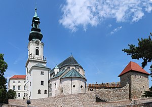
Nitra
City in Slovakia
Distance: Approx. 221 meters
Latitude and longitude: 48.30694444,18.08638889
Nitra (Slovak pronunciation: [ˈɲitra] ; also known by other alternative names) is a city in western Slovakia, situated at the foot of Zobor Mountain in the valley of the river Nitra. It is located 95 km east of Bratislava. With a population of about 78,353, it is the fifth largest city in Slovakia.

Nyitra County
County of the Kingdom of Hungary
Distance: Approx. 987 meters
Latitude and longitude: 48.31666667,18.08333333
Nyitra County (Hungarian: Nyitra vármegye; German: Neutraer Gespanschaft/Komitat Neutra; Latin: Comitatus Nitriensis; Slovak: Nitriansky komitát / Nitrianska stolica / Nitrianska župa) was an administrative county (comitatus) of the Kingdom of Hungary. Its territory lay in what is now western Slovakia.
Slovak University of Agriculture
Public university in Nitra, Slovakia
Distance: Approx. 820 meters
Latitude and longitude: 48.31472222,18.0875
Slovak University of Agriculture in Nitra is a public university in Nitra, Slovakia.
Nitra District
District in Nitra Region, Slovakia
Distance: Approx. 291 meters
Latitude and longitude: 48.31,18.08583333
Nitra District (Slovak: okres Nitra) is a district in the Nitra Region of western Slovakia. It is the second most populated of Slovakia's 79 districts, after Prešov District. Before 1996 the present-day district belonged to the West-Slovak region (Západoslovenský kraj).
St. Stephen's Church, Nitra
Distance: Approx. 487 meters
Latitude and longitude: 48.31201667,18.08193056
St. Stephen's Church is a protected cultural monument situated in Nitra. The beginning of the present-day church dates back to the 10th century.

Church of the Visitation of the Virgin Mary, Nitra
Church
Distance: Approx. 525 meters
Latitude and longitude: 48.3123,18.0858
The Church of the Visitation of the Virgin Mary (Slovak: Kostol Navštívenia Panny Márie) is a Roman Catholic church in Nitra, Slovakia. It was first built as a Gothic church in the 14th century. It was rebuilt in the Renaissance style in the first third of the 17th century and was then changed again to the Gothic style in the 18th century.

Nitra railway station
Railway station in Nitra, Slovakia
Distance: Approx. 767 meters
Latitude and longitude: 48.3015,18.0795
Nitra railway station is situated at Staničná street in the Staré Mesto district of Nitra, Slovakia. Nearby is a busy bus station and a bus stop served by the city's public transport network. Nitra is nowadays out of main railway corridors and the significance of railway transport is only regional.
United catholic school in Nitra, Slovakia
Distance: Approx. 869 meters
Latitude and longitude: 48.3,18.08333333
The complex of United catholic school consists of Secondary school of St. Cyril and Metod, Church of Visiting of virgin Mary and elementary school of St. Svorad and Benedikt.
Constantine the Philosopher University in Nitra
Public university in Nitra, Slovakia
Distance: Approx. 546 meters
Latitude and longitude: 48.3085,18.091
Constantine the Philosopher University in Nitra (Slovak: Univerzita Konštantína Filozofa v Nitre) is a co-educational public university in Nitra, located in southwestern Slovakia. It is a modern educational, scientific and artistic research institution that since 1996 bears the name of one of the most important personalities in Slovak history – Byzantine missionary Saint Cyril (born Constantine, 827–869), the "Apostle to the Slavs". UKF has five faculties and 7029 students, of which 5562 are enrolled in full-time study.

Nitra Synagogue
Former synagogue in Nitra, Slovakia
Distance: Approx. 465 meters
Latitude and longitude: 48.3116,18.0863
The Nitra Synagogue (Slovak: Synagoga v Nitre) is a former Neolog Jewish congregation and synagogue, located at 3 Pri synagóge Street, in Nitra, in the Nitra Region of Slovakia. The building operated as a place of worship between 1911 and World War II; and, since 2004, has operated as a cultural center.

Faculty Hospital, Nitra
Distance: Approx. 804 meters
Latitude and longitude: 48.3007,18.0857
The Faculty Hospital in Nitra (Slovak: Fakultná nemocnica Nitra) is a hospital in the city of Nitra, in western Slovakia. Its address is Špitalská 6, 950 01, Nitra. It is attached to the Constantine the Philosopher University in Nitra.

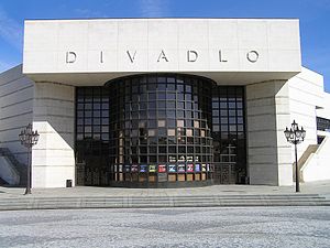
Andrej Bagar Theatre
Theatre in Nitra, Slovakia
Distance: Approx. 806 meters
Latitude and longitude: 48.31416667,18.08888889
The Andrej Bagar Theatre (Slovak: Divadlo Andreja Bagara) is a theatre located in Nitra, Slovakia. It opened in 1949. The theatre was known as Nitrianske krajové divadlo (Nitra Region Theatre) and Krajové divadlo Nitra (Regional Theatre Nitra) before being named after actor Andrej Bagar in 1979.
Weather in this IP's area
light rain
8 Celsius
5 Celsius
4 Celsius
8 Celsius
1009 hPa
91 %
1009 hPa
991 hPa
9358 meters
3.68 m/s
7.29 m/s
318 degree
100 %

