Country:
 Spain
SpainRegion:
City:
Latitude and Longitude:
Time Zone:
Postal Code:
IP information under different IP Channel
ip-api
Country
Region
City
ASN
Time Zone
ISP
Blacklist
Proxy
Latitude
Longitude
Postal
Route
IPinfo
Country
Region
City
ASN
Time Zone
ISP
Blacklist
Proxy
Latitude
Longitude
Postal
Route
MaxMind
Country
Region
City
ASN
Time Zone
ISP
Blacklist
Proxy
Latitude
Longitude
Postal
Route
Luminati
Country
ESRegion
an
City
albolote
ASN
Time Zone
Europe/Madrid
ISP
Radiocable Ingenieros S.l.
Latitude
Longitude
Postal
db-ip
Country
Region
City
ASN
Time Zone
ISP
Blacklist
Proxy
Latitude
Longitude
Postal
Route
ipdata
Country
Region
City
ASN
Time Zone
ISP
Blacklist
Proxy
Latitude
Longitude
Postal
Route
Popular places and events near this IP address

Atarfe
Municipality in Andalusia, Spain
Distance: Approx. 3023 meters
Latitude and longitude: 37.2229,-3.6899
Atarfe is a Spanish city in the north central part of the Vega of Granada in the province of Granada, Andalusia. It borders the municipalities of Moclín, Colomera, Albolote, Maracena, Granada, Santa Fe, and Pinos Puente. By this village run the Rivers Cubillas and Colomera.
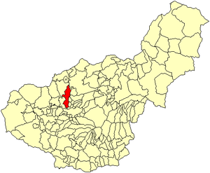
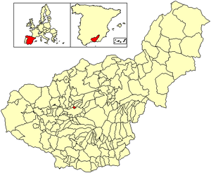
Albolote
City in Granada, Spain
Distance: Approx. 527 meters
Latitude and longitude: 37.23055556,-3.65694444
Albolote is a city located in the province of Granada, Spain. It is one of the thirty-four entities which together form Granada's Metropolitan Area. It is formed by several populations: El Aire, El Chaparral, and Parque del Cubillas y Pretel.

Calicasas
Place in Granada, Spain
Distance: Approx. 6583 meters
Latitude and longitude: 37.28333333,-3.61666667
Calicasas is a city in the province of Granada, Spain. According to the 2005 census (INE), the city has a population of 568 inhabitants.

Güevéjar
City in Granada, Spain
Distance: Approx. 6334 meters
Latitude and longitude: 37.26666667,-3.6
Güevéjar is a municipality located in the province of Granada, Spain. According to the 2023 census (INE), the city had a population of 2,546 inhabitants.

Maracena
City in Granada, Spain
Distance: Approx. 4516 meters
Latitude and longitude: 37.2,-3.63333333
Maracena is a municipality located in the province of Granada, Spain. According to the 2005 census (INE), the city has a population of 18819 inhabitants. It is located in the central part of the Vega de Granada, being one of the fifty-two entities that make up the metropolitan area of Granada.It borders the municipalities of Peligros, Pulianas, Granada, Atarfe and Albolote.

Peligros
City in Granada, Spain
Distance: Approx. 2308 meters
Latitude and longitude: 37.23333333,-3.63333333
Peligros is a municipality located in the province of Granada, Spain. According to the 2013 census (INE), the city has a population of 11,126 inhabitants. It is located next to Pulianas, Maracena, Albolote, Calicasas and Güevejar.

Pulianas
City in Granada, Spain
Distance: Approx. 5635 meters
Latitude and longitude: 37.21666667,-3.6
Pulianas is a municipality located in the province of Granada, Spain. According to the 2005 census (INE), the city has a population of 4842 inhabitants.
Jun, Granada
Place in Andalusia, Spain
Distance: Approx. 5635 meters
Latitude and longitude: 37.21666667,-3.6
Jun is a Spanish locality and township situated in the north-centre part of la Vega de Granada, in the province of Granada, autonomous community of Andalucía. It limits with the municipalities of Pulianas, Granada, Alfacar and Víznar. The municipality of Iundenia is one of the fifty two entities which make up the Metropolitan Area of Granada, and it is formed by Jun, Baltodano, and two streets of Pulianas: c/ Alhambra and c/ Generalife.
Cubillas Reservoir
Reservoir in Albolote and Chaparral
Distance: Approx. 4764 meters
Latitude and longitude: 37.27623889,-3.67321111
Cubillas Reservoir is a reservoir in the province of Granada, Andalusia, Spain. The Cubillas reservoir is placed between Sierra Elvira, the Colomeras mountains, and Sierra Arana (also known as Sierra Harana). The perimeter of the reservoir runs through the municipalities of Albolote and Atarfe in the province of Granada.
Club Recreativo Granada
Spanish football club
Distance: Approx. 6144 meters
Latitude and longitude: 37.208856,-3.598192
Club Recreativo Granada is a Spanish football team based in Granada, in the autonomous community of Andalusia. Founded in 1947, it is the reserve team of Granada CF and currently plays in Segunda Federación – Group 4, holding home games at Estadio Miguel Prieto, with a capacity for 2,500 spectators. Unlike the English League, reserve teams in Spain play in the same football pyramid as their senior team, rather than a separate league.
Ciudad Deportiva del Granada CF
Distance: Approx. 6047 meters
Latitude and longitude: 37.20805556,-3.6
The Ciudad Deportiva del Granada CF, is the training ground of the Spanish football club Granada CF, located in Granada, Spain. It occupies an area of 75,535 m2. The 1st phase of the training centre occupying an area of 47,833m², was completed earlier in 2015.
Monteluz
Locality in Granada, Spain
Distance: Approx. 2308 meters
Latitude and longitude: 37.23333333,-3.63333333
Monteluz is a locality belonging to the municipality of Peligros in the province of Granada, community of Andalusia, Spain. It is placed in the central part of the region of the Vega of Granada. Near this locality are Albolote's Cores, Cortijo del Aire and El Chaparral.
Weather in this IP's area
scattered clouds
27 Celsius
28 Celsius
26 Celsius
27 Celsius
1013 hPa
63 %
1013 hPa
941 hPa
10000 meters
3.09 m/s
320 degree
40 %
07:51:19
20:33:28