193.8.44.202 - IP Lookup: Free IP Address Lookup, Postal Code Lookup, IP Location Lookup, IP ASN, Public IP
Country:
Region:
City:
Location:
Time Zone:
Postal Code:
IP information under different IP Channel
ip-api
Country
Region
City
ASN
Time Zone
ISP
Blacklist
Proxy
Latitude
Longitude
Postal
Route
Luminati
Country
ASN
Time Zone
Europe/Zurich
ISP
Leica Geosystems AG
Latitude
Longitude
Postal
IPinfo
Country
Region
City
ASN
Time Zone
ISP
Blacklist
Proxy
Latitude
Longitude
Postal
Route
IP2Location
193.8.44.202Country
Region
sankt gallen
City
heerbrugg
Time Zone
Europe/Zurich
ISP
Language
User-Agent
Latitude
Longitude
Postal
db-ip
Country
Region
City
ASN
Time Zone
ISP
Blacklist
Proxy
Latitude
Longitude
Postal
Route
ipdata
Country
Region
City
ASN
Time Zone
ISP
Blacklist
Proxy
Latitude
Longitude
Postal
Route
Popular places and events near this IP address
Reute
Municipality in Appenzell Ausserrhoden, Switzerland
Distance: Approx. 3280 meters
Latitude and longitude: 47.41666667,9.58333333
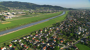
Reute (Swiss Standard German pronunciation: [ˈrɔʏtɛ]) is a municipality in the canton of Appenzell Ausserrhoden in Switzerland.

Lustenau
Municipality in Vorarlberg, Austria
Distance: Approx. 2978 meters
Latitude and longitude: 47.42972222,9.65972222
Lustenau ([ˈluːstənaʊ]; Alemannic German: Luschnou) is a town in the westernmost Austrian state of Vorarlberg in the district of Dornbirn. It lies on the river Rhine, which forms the border with Switzerland. Lustenau is Vorarlberg's fourth largest town.

Reichshofstadion
Multi-use stadium in Lustenau, Austria
Distance: Approx. 2075 meters
Latitude and longitude: 47.42111111,9.65277778
Planet Pure Stadion is a multi-use stadium in Lustenau, Austria, built in 1951. It is currently used mostly for football matches and is the home ground of SC Austria Lustenau and FC Lustenau 07. The stadium holds 5,138 people, of which 3,094 seats and 2,044 standing.

Au, St. Gallen
Municipality in St. Gallen, Switzerland
Distance: Approx. 2110 meters
Latitude and longitude: 47.43333333,9.63333333
Au is a municipality in the Wahlkreis (constituency) of Rheintal in the canton of St. Gallen in Switzerland.
Balgach
Municipality in St. Gallen, Switzerland
Distance: Approx. 2613 meters
Latitude and longitude: 47.4,9.6
Balgach is a municipality in the Wahlkreis (constituency) of Rheintal in the canton of St. Gallen in Switzerland.
Berneck, St. Gallen
Municipality in St. Gallen, Switzerland
Distance: Approx. 2189 meters
Latitude and longitude: 47.43333333,9.61666667
Berneck is a municipality in the Wahlkreis (constituency) of Rheintal in the canton of St. Gallen in Switzerland.

Rebstein
Municipality in St. Gallen, Switzerland
Distance: Approx. 3671 meters
Latitude and longitude: 47.4,9.58333333
Rebstein is a municipality in the Wahlkreis (constituency) of Rheintal in the canton of St. Gallen in Switzerland.
Widnau
Municipality in St. Gallen, Switzerland
Distance: Approx. 1730 meters
Latitude and longitude: 47.4,9.63333333
Widnau is a municipality in the Wahlkreis (constituency) of Rheintal in the canton of St. Gallen in Switzerland.

Au SG railway station
Railway station in Switzerland
Distance: Approx. 2839 meters
Latitude and longitude: 47.43833333,9.64166667
Au SG railway station (German: Bahnhof Au SG) is a railway station in Au, in the Swiss canton of St. Gallen (abbreviated to SG). It is an intermediate stop on the Chur–Rorschach line.

Heerbrugg railway station
Railway station in the canton of St. Gallen, Switzerland
Distance: Approx. 240 meters
Latitude and longitude: 47.415,9.62361111
Heerbrugg railway station (German: Bahnhof Heerbrugg) is a railway station in Au, in the Swiss canton of St. Gallen. It is an intermediate stop on the Chur–Rorschach line.

Rebstein-Marbach railway station
Railway station in Switzerland
Distance: Approx. 3913 meters
Latitude and longitude: 47.39888889,9.58055556
Rebstein-Marbach railway station (German: Bahnhof Rebstein-Marbach) is a railway station in Rebstein, in the Swiss canton of St. Gallen. It is an intermediate stop on the Chur–Rorschach line.

Grimmenstein monastery
Distance: Approx. 3346 meters
Latitude and longitude: 47.4434,9.6127
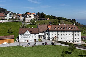
Grimmenstein Monastery is a monastery of Sisters of the Third Order of Saint Francis in Walzenhausen in the canton of Appenzell Ausserrhoden in Switzerland. While it is located in Appenzell Ausserrhoden, the buildings and grounds are a small exclave of the canton of Appenzell Innerrhoden.
Weather in this IP's area
broken clouds
-0 Celsius
-2 Celsius
-1 Celsius
-0 Celsius
1035 hPa
96 %
1035 hPa
954 hPa
10000 meters
1.54 m/s
100 degree
58 %


