Country:
 Switzerland
Region:
City:
Latitude and Longitude:
Time Zone:
Postal Code:
IP information under different IP Channel
ip-api
Country
Region
City
ASN
Time Zone
ISP
Blacklist
Proxy
Latitude
Longitude
Postal
Route
IPinfo
Country
Region
City
ASN
Time Zone
ISP
Blacklist
Proxy
Latitude
Longitude
Postal
Route
MaxMind
Country
Region
City
ASN
Time Zone
ISP
Blacklist
Proxy
Latitude
Longitude
Postal
Route
Luminati
Country
CHASN
Time Zone
Europe/Zurich
ISP
green.ch AG
Latitude
Longitude
Postal
db-ip
Country
Region
City
ASN
Time Zone
ISP
Blacklist
Proxy
Latitude
Longitude
Postal
Route
ipdata
Country
Region
City
ASN
Time Zone
ISP
Blacklist
Proxy
Latitude
Longitude
Postal
Route
Popular places and events near this IP address
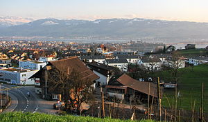
Rapperswil-Jona
Municipality in St. Gallen, Switzerland
Distance: Approx. 2186 meters
Latitude and longitude: 47.21666667,8.81666667
Rapperswil-Jona is a municipality in the Wahlkreis (constituency) of See-Gaster in the canton of St. Gallen in Switzerland. Besides Rapperswil and Jona, which were separate municipalities until 2006, Rapperswil-Jona also includes Bollingen, Busskirch, Curtiberg, Kempraten-Lenggis, and Wagen.

Jona, Switzerland
Former municipality of Switzerland in St. Gallen
Distance: Approx. 2186 meters
Latitude and longitude: 47.21666667,8.81666667
Jona is a former municipality and since January 2007 part of the municipality of Rapperswil-Jona in the Wahlkreis (constituency) of See-Gaster in the canton of St. Gallen in Switzerland. Before the merger with Rapperswil, the former municipality of Jona comprised the villages of Jona, Bollingen, Busskirch, Curtiberg, Kempraten-Lenggis, and Wagen.

Hurden
Former municipality in Schwyz, Switzerland
Distance: Approx. 1872 meters
Latitude and longitude: 47.19333333,8.77666667
Hurden is a village in the municipality of Freienbach in the canton of Schwyz in Switzerland. First mentioned in 1217, the name "de Hurden" was used for the peninsula and for the fish traps made of woven work, called "Hürden" or "Hurden", which were used by the locals.
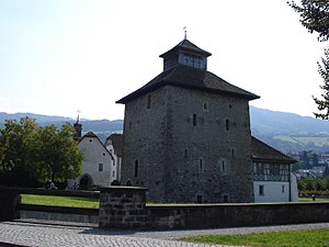
Pfäffikon Castle
Distance: Approx. 1808 meters
Latitude and longitude: 47.204642,8.774851
Pfäffikon Castle is a castle in the municipality of Freienbach of the Canton of Schwyz in Switzerland. It is a Swiss heritage site of national significance.

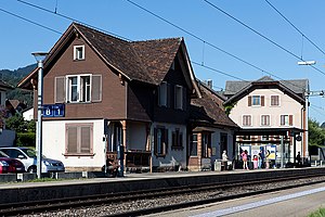
Pfäffikon SZ railway station
Railway station in Pfäffikon, Schwyz, Switzerland
Distance: Approx. 1536 meters
Latitude and longitude: 47.203,8.77811111
Pfäffikon SZ railway station (German: Bahnhof Pfäffikon SZ) is a junction station serving Pfäffikon, the principal town of the municipality of Freienbach, in the canton of Schwyz (SZ), Switzerland. The station is situated at the northern edge of the town, between the town centre and Lake Zurich. The station forms part of the Lake Zürich left-bank railway line, which links Zürich Hauptbahnhof with Ziegelbrücke and Näfels, and is owned and operated by the Swiss Federal Railways (SBB).

Hurden railway station
Railway station in Freienbach, Switzerland
Distance: Approx. 1362 meters
Latitude and longitude: 47.213629,8.80066
Hurden railway station is a railway station in the Swiss canton of Schwyz and municipality of Freienbach. The station is located on the Rapperswil to Pfäffikon line that crosses the Seedamm between the two shores of Lake Zurich. It takes its name from the nearby village of Hurden.
Altendorf railway station
Railway station in Switzerland
Distance: Approx. 2039 meters
Latitude and longitude: 47.194,8.82288889
Altendorf railway station is a railway station in the Swiss canton of Schwyz and municipality of Altendorf. The station is located on the Lake Zurich left-bank railway line, owned by the Swiss Federal Railways (SBB).

Hurden ship canal
Distance: Approx. 749 meters
Latitude and longitude: 47.207505,8.793831
The Hurden ship canal (German: Schiffahrtskanal von Hurden) is a 500-metre (1,600 ft) long canal in the Swiss canton of Schwyz. It connects the lower section of Lake Zürich with the upper section, sometimes called the Obersee, permitting shipping services on the lake to pass between the two halves of the lake without passing through the shallows, and under the low bridges, of the Seedamm. The canal was opened in 1943, and cuts through the base of the peninsular containing the village of Hurden, thus placing the centre of the village on an artificial island.

Frauenwinkel
Mire landscape in Switzerland
Distance: Approx. 869 meters
Latitude and longitude: 47.20895833,8.79488889
Frauenwinkel is a mire landscape in Switzerland, situated at the Seedamm area on Zürichsee lakeshore in the municipality of Freienbach in the Canton of Schwyz.

Freienbach–Hurden Rosshorn
UNESCO World Heritage Site in Canton of Schwyz, Switzerland
Distance: Approx. 2110 meters
Latitude and longitude: 47.21955,8.80683611
Freienbach–Hurden Rosshorn, more often called Hurden Rosshorn or simply Rosshorn, is one of the 111 serial sites of the UNESCO World Heritage Prehistoric pile dwellings around the Alps, of which are 56 located in Switzerland. The Rosshorn site is exceptional because it doesn't contain remains of a prehistoric settlement but instead remains of prehistoric and historic bridges that were built in a shallow area of Lake Zurich.

Freienbach–Hurden Seefeld
UNESCO World Heritage Site in Canton of Schwyz, Switzerland
Distance: Approx. 1203 meters
Latitude and longitude: 47.21196111,8.80228333
Freienbach–Hurden Seefeld is one of the 111 serial sites of the UNESCO World Heritage Site Prehistoric pile dwellings around the Alps, of which are 56 located in Switzerland.

Seedamm-Center
Shopping mall in Pfäffikon
Distance: Approx. 554 meters
Latitude and longitude: 47.201963,8.791013
Seedamm-Center is a subsidiary of the Swiss Vögele Group which runs the shopping mall in the locality Pfäffikon of the municipality of Freienbach in the Canton of Schwyz.
Weather in this IP's area
overcast clouds
14 Celsius
14 Celsius
12 Celsius
16 Celsius
1019 hPa
98 %
1019 hPa
968 hPa
10000 meters
0.89 m/s
1.79 m/s
342 degree
100 %
07:48:58
18:30:08