Country:
 Switzerland
Region:
City:
Latitude and Longitude:
Time Zone:
Postal Code:
IP information under different IP Channel
ip-api
Country
Region
City
ASN
Time Zone
ISP
Blacklist
Proxy
Latitude
Longitude
Postal
Route
IPinfo
Country
Region
City
ASN
Time Zone
ISP
Blacklist
Proxy
Latitude
Longitude
Postal
Route
MaxMind
Country
Region
City
ASN
Time Zone
ISP
Blacklist
Proxy
Latitude
Longitude
Postal
Route
Luminati
Country
CHASN
Time Zone
Europe/Zurich
ISP
green.ch AG
Latitude
Longitude
Postal
db-ip
Country
Region
City
ASN
Time Zone
ISP
Blacklist
Proxy
Latitude
Longitude
Postal
Route
ipdata
Country
Region
City
ASN
Time Zone
ISP
Blacklist
Proxy
Latitude
Longitude
Postal
Route
Popular places and events near this IP address

Greifensee (lake)
Lake in Switzerland
Distance: Approx. 2389 meters
Latitude and longitude: 47.35,8.68333333
Greifensee is a lake in the canton of Zürich in Switzerland.

Greifensee, Zürich
Municipality in Zürich, Switzerland
Distance: Approx. 628 meters
Latitude and longitude: 47.36666667,8.68333333
Greifensee is a municipality in the district of Uster in the Canton of Zurich in Switzerland.

Aabach (Greifensee)
River in Switzerland
Distance: Approx. 2319 meters
Latitude and longitude: 47.3516,8.6888
The Aabach (also Aa, or Ustermer Aa for disambiguation with the Mönchaltorfer Aa) is a minor river in the canton of Zürich, Switzerland. At a length of 11.2 kilometres (7.0 mi), it flows from Pfäffikersee to the Greifensee. Its valley is known as Aatal ("Aa Valley"), eponymous of the settlement Aathal.
Uster District
District in Switzerland
Distance: Approx. 2389 meters
Latitude and longitude: 47.35,8.68333333
Uster District is one of the twelve districts of the canton of Zürich, Switzerland. Its capital is the city of Uster. The German-speaking district has a population of 135,234 (as of 31 December 2020).
Maur, Switzerland
Municipality in Zurich, Switzerland
Distance: Approx. 2520 meters
Latitude and longitude: 47.35,8.66666667
Maur is a municipality in the district of Uster in the canton of Zürich in Switzerland.

Schwerzenbach
Municipality in Zürich, Switzerland
Distance: Approx. 1614 meters
Latitude and longitude: 47.38333333,8.66666667
Schwerzenbach is a municipality in the district of Uster in the canton of Zürich in Switzerland, and belongs to the Glatt Valley (German: Glattal). The municipality was first mentioned in year 1064 as Swerzenbach.

Volketswil
Municipality in Zurich, Switzerland
Distance: Approx. 2117 meters
Latitude and longitude: 47.38333333,8.7
Volketswil is a municipality in the district of Uster in the canton of Zürich in Switzerland. The municipality in the agglomeration of Zurich includes the villages of Volketswil, Hegnau, Zimikon, Kindhausen and Gutenswil.

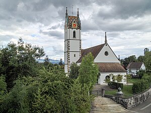
Greifensee Reformed Church
Distance: Approx. 711 meters
Latitude and longitude: 47.36489,8.67691
Reformierte Kirche Greifensee (native German name, literally: Greifensee Reformed Church or commonly Gallus-Kapelle Im Städtli), is a church and a listed heritage building in the municipality of Greifensee, Canton of Zürich, Switzerland.

Greifensee Castle
Distance: Approx. 716 meters
Latitude and longitude: 47.365037,8.675652
Greifensee Castle (German: Schloss Greifensee) is a castle in the municipality of Greifensee and the canton of Zurich in Switzerland. It was probably built by the House of Rapperswil and is a Swiss heritage site of national significance.
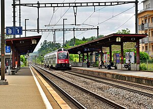
Nänikon-Greifensee railway station
Railway station in Canton of Zürich, Switzerland
Distance: Approx. 665 meters
Latitude and longitude: 47.36907,8.686624
Nänikon-Greifensee is a railway station in the Swiss canton of Zürich. It is situated between the villages of Nänikon, in the municipality of Uster, and the town of Greifensee. The station is on the Wallisellen–Uster–Rapperswil line.
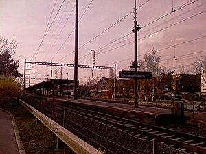
Schwerzenbach railway station
Railway station in Switzerland
Distance: Approx. 2079 meters
Latitude and longitude: 47.384571,8.659126
Schwerzenbach is a railway station in the Swiss canton of Zurich. It is situated in the municipality of Schwerzenbach on the Wallisellen–Uster–Rapperswil line. It is the main station serving the communities of Schwerzenbach and Volketswil, with close proximity to the Volkiland shopping center and Milandia entertainment park.

Greifensee–Storen/Wildsberg
UNESCO World Heritage Site in Canton of Zürich, Switzerland
Distance: Approx. 1207 meters
Latitude and longitude: 47.36050278,8.680975
Greifensee–Storen–Wildsberg is one of the 111 serial sites of the UNESCO World Heritage Site Prehistoric pile dwellings around the Alps, of which are 56 located in Switzerland.
Weather in this IP's area
overcast clouds
13 Celsius
13 Celsius
12 Celsius
15 Celsius
1019 hPa
91 %
1019 hPa
966 hPa
8000 meters
1.03 m/s
100 %
07:49:40
18:30:20