Country:
 Switzerland
Region:
City:
Latitude and Longitude:
Time Zone:
Postal Code:
IP information under different IP Channel
ip-api
Country
Region
City
ASN
Time Zone
ISP
Blacklist
Proxy
Latitude
Longitude
Postal
Route
IPinfo
Country
Region
City
ASN
Time Zone
ISP
Blacklist
Proxy
Latitude
Longitude
Postal
Route
MaxMind
Country
Region
City
ASN
Time Zone
ISP
Blacklist
Proxy
Latitude
Longitude
Postal
Route
Luminati
Country
CHASN
Time Zone
Europe/Zurich
ISP
green.ch AG
Latitude
Longitude
Postal
db-ip
Country
Region
City
ASN
Time Zone
ISP
Blacklist
Proxy
Latitude
Longitude
Postal
Route
ipdata
Country
Region
City
ASN
Time Zone
ISP
Blacklist
Proxy
Latitude
Longitude
Postal
Route
Popular places and events near this IP address
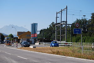
Root, Switzerland
Municipality in Lucerne, Switzerland
Distance: Approx. 2368 meters
Latitude and longitude: 47.11666667,8.38333333
Root is a municipality in the district of Lucerne in the canton of Lucerne in Switzerland.
Buchrain
Municipality in Lucerne, Switzerland
Distance: Approx. 988 meters
Latitude and longitude: 47.1,8.35
Buchrain is a municipality in the district of Lucerne in the canton of Lucerne in Switzerland.

Dierikon
Municipality in Lucerne, Switzerland
Distance: Approx. 1300 meters
Latitude and longitude: 47.1,8.36666667
Dierikon is a municipality in the district of Lucerne in the canton of Lucerne, Switzerland.
Inwil
Municipality in Lucerne, Switzerland
Distance: Approx. 994 meters
Latitude and longitude: 47.11666667,8.35
Inwil is a municipality in the district of Hochdorf in the canton of Lucerne in Switzerland.

A14 motorway (Switzerland)
Motorway in Switzerland
Distance: Approx. 1098 meters
Latitude and longitude: 47.117343,8.360392
The A14 motorway, an Autobahn in central Switzerland, is a divided highway connecting the A2 with the A4, within the Canton of Lucerne. The A14 is congruent with the National Road N14 and part of the main traffic artery between the Innerschweitz and the metropolitan area Zürich. It runs mostly along the Reuss (river), which it twice crosses.
Götzental Castle
Distance: Approx. 2501 meters
Latitude and longitude: 47.091792,8.376996
Götzental Castle is a castle in the municipality of Dierikon of the Canton of Lucerne in Switzerland. It is a Swiss heritage site of national significance.
Rooterberg
Mountain in Switzerland
Distance: Approx. 3188 meters
Latitude and longitude: 47.09805556,8.39388889
The Rooterberg (840 m) is a mountain north of the Alps, located between Root and Udligenswil in the canton of Lucerne. The mountain lies north of Lake Lucerne and west of Lake Zug, at the foothills of the Alps.

Mall of Switzerland
Shopping mall in Ebikon, Switzerland
Distance: Approx. 1629 meters
Latitude and longitude: 47.0938746,8.3582267
The Mall of Switzerland is the biggest shopping mall in Central Switzerland. It is located in Ebikon. The mall contains 150 shops, that are located on 3 floors.

Ebikon railway station
Swiss railway station
Distance: Approx. 2832 meters
Latitude and longitude: 47.08426306,8.34235806
Ebikon railway station (German: Bahnhof Ebikon) is a railway station in the municipality of Ebikon, in the Swiss canton of Lucerne. It is an intermediate stop on the standard gauge Zug–Lucerne line of Swiss Federal Railways.

Buchrain railway station
Swiss railway station
Distance: Approx. 1638 meters
Latitude and longitude: 47.09365,8.35665806
Buchrain railway station (German: Bahnhof Buchrain) is a railway station in the municipality of Ebikon, in the Swiss canton of Lucerne. It is an intermediate stop on the standard gauge Zug–Lucerne line of Swiss Federal Railways. The station takes its name from the nearby municipality of Buchrain.

Root D4 railway station
Swiss railway station
Distance: Approx. 1505 meters
Latitude and longitude: 47.10485611,8.37380806
Root D4 railway station (German: Bahnhof Root D4) is a railway station in the municipality of Root, in the Swiss canton of Lucerne. It is an intermediate stop on the standard gauge Zug–Lucerne line of Swiss Federal Railways. The station takes its name from the nearby D4 Business Village Luzern.

Waldibrücke railway station
Swiss railway station
Distance: Approx. 2646 meters
Latitude and longitude: 47.10788889,8.31968056
Waldibrücke railway station (German: Bahnhof Waldibrücke) is a railway station in the municipality of Emmen, in the Swiss canton of Lucerne. It is an intermediate stop on the standard gauge Seetal line of Swiss Federal Railways.
Weather in this IP's area
light intensity shower rain
19 Celsius
19 Celsius
18 Celsius
20 Celsius
1009 hPa
90 %
1009 hPa
962 hPa
10000 meters
2.57 m/s
70 degree
75 %
06:55:27
19:53:15