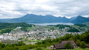
Country:
 Switzerland
Region:
City:
Latitude and Longitude:
Time Zone:
Postal Code:
IP information under different IP Channel
ip-api
Country
Region
City
ASN
Time Zone
ISP
Blacklist
Proxy
Latitude
Longitude
Postal
Route
IPinfo
Country
Region
City
ASN
Time Zone
ISP
Blacklist
Proxy
Latitude
Longitude
Postal
Route
MaxMind
Country
Region
City
ASN
Time Zone
ISP
Blacklist
Proxy
Latitude
Longitude
Postal
Route
Luminati
Country
CHASN
Time Zone
Europe/Zurich
ISP
green.ch AG
Latitude
Longitude
Postal
db-ip
Country
Region
City
ASN
Time Zone
ISP
Blacklist
Proxy
Latitude
Longitude
Postal
Route
ipdata
Country
Region
City
ASN
Time Zone
ISP
Blacklist
Proxy
Latitude
Longitude
Postal
Route
Popular places and events near this IP address
SC Kriens
Swiss football club
Distance: Approx. 2135 meters
Latitude and longitude: 47.02983611,8.28779722
SC Kriens is a football club based in Kriens, Switzerland, that currently competing in the Swiss Promotion League. The club uses Stadion Kleinfeld as home ground, and form a local rivalry with Lucerne. SC Kriens women's team has been participating in the Nationalliga A since 2008.
Horw
Municipality in Lucerne, Switzerland
Distance: Approx. 635 meters
Latitude and longitude: 47.01666667,8.31666667
Horw (German pronunciation: [hɔʁv]; Swiss German: Horb) is a municipality in the district of Lucerne in the canton of Lucerne in Switzerland.
Stadion Allmend
Distance: Approx. 1859 meters
Latitude and longitude: 47.033264,8.305187
Stadion Allmend was a multi-purpose stadium in Lucerne, Switzerland. Its current primary use was for football matches. The stadium had a capacity of 25,000, although security concerns mandate limiting audiences to 15,000.
IMI International Management Institute Switzerland
Distance: Approx. 2450 meters
Latitude and longitude: 47.0069,8.3372
IMI International Management Institute, Switzerland is a private hospitality school offering programmes from Foundation level to Master of Science. It offers students the opportunity to undertake paid, practical internships as part of their programme either in Switzerland or internationally. It is one of Switzerland's smaller private hotel schools (with a maximum of 200 students per semester) and aims to offer students a highly personalised educational experience.
Hubelmatt Observatory
Observatory
Distance: Approx. 2059 meters
Latitude and longitude: 47.0351,8.3056
Hubelmatt Observatory (German: Sternwarte Hubelmatt) is an astronomical observatory in Lucerne, Switzerland, billeted at the city's Hubelmatt West School. Built in 1979, it is operated by the Astronomical Society of Lucerne (German: Astronomische Gesellschaft Luzern). On 12 February 2017, the inner main-belt asteroid 6126 Hubelmatt, discovered by Zdeňka Vávrová at Kleť Observatory, was named in honor of the observatory and its hosting school.
Lucerne University of Applied Sciences and Arts
Public university in Lucerne, Switzerland
Distance: Approx. 348 meters
Latitude and longitude: 47.014,8.306
Lucerne University of Applied Sciences and Arts (German: Hochschule Luzern) (HSLU) is one of seven regional, public-funded universities of applied sciences founded in 1997 in its current form. The University was called University of Applied Sciences of Central Switzerland (German: Fachhochschule Zentralschweiz) until 15 October 2007. Lucerne University of Applied Sciences and Arts is a Swiss public vocational university with campuses in Lucerne, Horw, Emmenbrücke and Rotkreuz.

Swissporarena
Football stadium in Lucerne, Switzerland
Distance: Approx. 1863 meters
Latitude and longitude: 47.0333,8.3052
Swissporarena is a multi-use stadium in Lucerne, Switzerland, completed in 2011. It is used mostly for football matches and hosts the home matches of FC Luzern of the Swiss Super League. The stadium has a capacity of 16,800 spectators, including an away fans' section fitted with 390 rail seats for safe standing.

Kriens Mattenhof railway station
Railway station in Switzerland
Distance: Approx. 1192 meters
Latitude and longitude: 47.02661,8.30236111
Kriens Mattenhof railway station is a Swiss railway station in the municipality of Kriens in the canton of Lucerne. It is on the Brünig line of the Zentralbahn railway company, which links Lucerne and Interlaken, and is also used by trains of the Luzern–Stans–Engelberg line. Immediately to the north of Kriens Mattenhof station, the railway enters a tunnel as far as the approaches to Lucerne station, calling at the underground Lucerne Allmend/Messe station on the way.

Luzern Allmend/Messe railway station
Railway station in Switzerland
Distance: Approx. 2081 meters
Latitude and longitude: 47.03508056,8.3033
Luzern Allmend/Messe railway station (German: Bahnhof Luzern Allmend/Messe) is a railway station in the city of Lucerne, in the Swiss canton of Lucerne. It is located adjacent to the Swissporarena, in the south of the city. The station is on the Brünig line of the Zentralbahn railway company, and is used by trains of the Luzern–Stans–Engelberg line.

Horw railway station
Railway station in Switzerland
Distance: Approx. 133 meters
Latitude and longitude: 47.01746944,8.30696111
Horw railway station is a Swiss railway station in the municipality of Horw in the canton of Lucerne. It is on the Brünig line of the Zentralbahn railway company, which links Lucerne and Interlaken, and is also used by trains of the Luzern–Stans–Engelberg line.
Lucerne-Stadt District
District in Switzerland
Distance: Approx. 1956 meters
Latitude and longitude: 47.03333333,8.3
Lucerne-Stadt District (German: Wahlkreis Luzern-Stadt) is one of the two new Wahlkreis formed from the former Lucerne Amt in 2013 in the Canton of Lucerne, Switzerland. It has a population of 82,620 (as of 31 December 2020) and includes only the city of Lucerne. ^a 1992/97 survey gives a total area of 216.65 km2 (83.65 sq mi) without including certain large lakes, while the 2000 survey includes lakes and gives the higher value.

Schauensee Castle
Distance: Approx. 2372 meters
Latitude and longitude: 47.02735556,8.28123611
Schauensee Castle is a castle in the municipality of Kriens of the Canton of Lucerne in Switzerland.
Weather in this IP's area
overcast clouds
11 Celsius
11 Celsius
11 Celsius
14 Celsius
1019 hPa
96 %
1019 hPa
967 hPa
10000 meters
2.06 m/s
20 degree
100 %
07:50:40
18:32:22