Country:
 Switzerland
Region:
City:
Latitude and Longitude:
Time Zone:
Postal Code:
IP information under different IP Channel
ip-api
Country
Region
City
ASN
Time Zone
ISP
Blacklist
Proxy
Latitude
Longitude
Postal
Route
IPinfo
Country
Region
City
ASN
Time Zone
ISP
Blacklist
Proxy
Latitude
Longitude
Postal
Route
MaxMind
Country
Region
City
ASN
Time Zone
ISP
Blacklist
Proxy
Latitude
Longitude
Postal
Route
Luminati
Country
CHASN
Time Zone
Europe/Zurich
ISP
green.ch AG
Latitude
Longitude
Postal
db-ip
Country
Region
City
ASN
Time Zone
ISP
Blacklist
Proxy
Latitude
Longitude
Postal
Route
ipdata
Country
Region
City
ASN
Time Zone
ISP
Blacklist
Proxy
Latitude
Longitude
Postal
Route
Popular places and events near this IP address

Ittigen
Municipality in Bern, Switzerland
Distance: Approx. 260 meters
Latitude and longitude: 46.98333333,7.48333333
Ittigen is a municipality in the Bern-Mittelland administrative district in the canton of Bern in Switzerland. The municipality was formed in 1983 when it and Ostermundigen were separated from territory once part of Bolligen.

Bolligen
Municipality in Bern, Switzerland
Distance: Approx. 1309 meters
Latitude and longitude: 46.98333333,7.5
Bolligen is a municipality in the Bern-Mittelland administrative district of the canton of Bern, Switzerland. In the historical center is a twelfth-century church, with a benefice barn and parsonage from the 16th century.

Ittigen Castle
Building in Ittigen
Distance: Approx. 669 meters
Latitude and longitude: 46.975,7.4837
Ittigen Castle (also Campagne Thalgut or Landsitz Thal) is a historical country house in Ittigen in the Canton of Bern in Switzerland.

Federal Office for the Environment
Swiss environmental agency
Distance: Approx. 856 meters
Latitude and longitude: 46.97361111,7.48
The Federal Office for the Environment (German: Bundesamt für Umwelt; French: Office fédéral de l'environnement; Italian: Ufficio federale dell'ambiente) is the Swiss environmental agency, a division of the Federal Department of Environment, Transport, Energy and Communications. It is responsible for matters of the environment, including the protection of plants and animals and the protection against noise, air pollution or natural hazards.

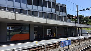
Papiermühle railway station
Railway station in Ittigen, Switzerland
Distance: Approx. 899 meters
Latitude and longitude: 46.97427,7.47656
Papiermühle railway station (German: Bahnhof Papiermühle) is a railway station in the municipality of Ittigen, in the Swiss canton of Bern. It is an intermediate stop on the 1,000 mm (3 ft 3+3⁄8 in) gauge Worb Dorf–Worblaufen line of Regionalverkehr Bern-Solothurn.

Ittigen bei Bern railway station
Railway station in Ittigen, Switzerland
Distance: Approx. 886 meters
Latitude and longitude: 46.97305556,7.48388889
Ittigen bei Bern railway station (German: Bahnhof Ittigen bei Bern), also known as Ittigen railway station, is a railway station in the municipality of Ittigen, in the Swiss canton of Bern. It is an intermediate stop on the 1,000 mm (3 ft 3+3⁄8 in) gauge Worb Dorf–Worblaufen line of Regionalverkehr Bern-Solothurn.
Bolligen railway station
Railway station in Bolligen, Switzerland
Distance: Approx. 1614 meters
Latitude and longitude: 46.97,7.49694444
Bolligen railway station (German: Bahnhof Bolligen) is a railway station in the municipality of Bolligen, in the Swiss canton of Bern. It is an intermediate stop on the 1,000 mm (3 ft 3+3⁄8 in) gauge Worb Dorf–Worblaufen line of Regionalverkehr Bern-Solothurn.

Steinibach railway station
Railway station in Zollikofen, Switzerland
Distance: Approx. 1916 meters
Latitude and longitude: 46.98305556,7.45805556
Steinibach railway station (German: Bahnhof Steinibach) is a railway station in the municipality of Zollikofen, in the Swiss canton of Bern. It is an intermediate stop on the 1,000 mm (3 ft 3+3⁄8 in) gauge Zollikofen–Bern line of Regionalverkehr Bern-Solothurn.

Federal Office for Spatial Development
Swiss federal agency
Distance: Approx. 856 meters
Latitude and longitude: 46.97361111,7.48
The Federal Office for Spatial Development (ARE) (German: Bundesamt für Raumentwicklung; French: Office fédéral du développement territorial; Italian: Ufficio federale dello sviluppo territoriale) is a Swiss federal office. Its acronym, ARE, is used in all languages and derives from the office's German name. Created on June 1, 2000, the office is responsible for spatial planning, transport coordination and sustainable development.

Federal Office of Communications
Swiss federal agency
Distance: Approx. 856 meters
Latitude and longitude: 46.97361111,7.48
The Federal Office of Communications (OFCOM) (German: Bundesamt für Kommunikation, BAKOM; French: Office fédéral de la communication, OFCOM; Italian: Ufficio federale delle comunicazioni, UFCOM) is a Swiss federal office that deals with issues relating to telecommunications, broadcasting and postal services in Switzerland. Created in 1992, the office is attached to the Federal Department of the Environment, Transport, Energy and Communications (DETEC), and is based in Biel/Bienne. The OFCOM's activities are governed by the Swiss Telecommunications Act (TCA), the Federal Act on Radio and Television (RTVA) and the Federal Postal Act.

Federal Office of Energy
Swiss federal agency
Distance: Approx. 856 meters
Latitude and longitude: 46.97361111,7.48
The Swiss Federal Office of Energy (SFOE) (German: Bundesamt für Energie, BFE; French: Office fédéral de l'énergie, OFEN; Italian: Ufficio federale dell'energia, UFE) is a Swiss federal office responsible for issues relating to energy supply and energy consumption.
Federal Roads Office
Swiss federal agency
Distance: Approx. 856 meters
Latitude and longitude: 46.97361111,7.48
The Federal Roads Office (FEDRO) (German: Bundesamt für Strassen, ASTRA; French: Office fédéral des routes, OFROU; Italian: Ufficio federale delle strade, USTRA) is a Swiss federal office responsible for road infrastructure and private road transport.
Weather in this IP's area
light rain
18 Celsius
18 Celsius
16 Celsius
19 Celsius
1009 hPa
84 %
1009 hPa
944 hPa
5767 meters
0.28 m/s
0.41 m/s
229 degree
100 %
06:59:04
19:56:37