Country:
 Switzerland
Region:
City:
Latitude and Longitude:
Time Zone:
Postal Code:
IP information under different IP Channel
ip-api
Country
Region
City
ASN
Time Zone
ISP
Blacklist
Proxy
Latitude
Longitude
Postal
Route
IPinfo
Country
Region
City
ASN
Time Zone
ISP
Blacklist
Proxy
Latitude
Longitude
Postal
Route
MaxMind
Country
Region
City
ASN
Time Zone
ISP
Blacklist
Proxy
Latitude
Longitude
Postal
Route
Luminati
Country
CHASN
Time Zone
Europe/Zurich
ISP
green.ch AG
Latitude
Longitude
Postal
db-ip
Country
Region
City
ASN
Time Zone
ISP
Blacklist
Proxy
Latitude
Longitude
Postal
Route
ipdata
Country
Region
City
ASN
Time Zone
ISP
Blacklist
Proxy
Latitude
Longitude
Postal
Route
Popular places and events near this IP address
Baregg
Hill in northern Switzerland
Distance: Approx. 1005 meters
Latitude and longitude: 47.455,8.2986
Baregg is the name of a hill in northern Switzerland. Until 1960, it remained an insignificant hill in the Swiss plains. However, with the onslaught of more vehicle traffic, Baregg became more and more of a problem.

Canton of Baden
Canton of the Helvetic Republic
Distance: Approx. 873 meters
Latitude and longitude: 47.46666667,8.3
The Canton of Baden (German: Kanton Baden) was a canton of the Helvetic Republic (a Napoleonic-era precursor of modern-day Switzerland). Its capital was the town of Baden.

Baregg Tunnel
Motorway tunnel near the city of Baden in Swiss canton of Aargau
Distance: Approx. 763 meters
Latitude and longitude: 47.46,8.29833333
The Baregg Tunnel is a motorway tunnel near the city of Baden in Swiss canton of Aargau, which forms part of the A1 motorway between western Switzerland and Zürich. The tunnel comprises three bores through Baregg, built at two different times. The first two bores, each carrying two traffic lanes, were opened in 1970 and are 1,390 metres (4,560 ft) long.
Baden District, Aargau
District in Switzerland
Distance: Approx. 873 meters
Latitude and longitude: 47.46666667,8.3
Baden District is a district in the canton of Aargau, Switzerland. The district capital is the town of Baden and the largest municipality is Wettingen, located in the Limmat Valley (German: Limmattal). The district has a total of 25 municipalities, an area of 153.07 km2 (59.10 sq mi), and a population (as of 2014) of about 138,000.

Wettingen Abbey
Distance: Approx. 787 meters
Latitude and longitude: 47.4575,8.31722222
Wettingen Abbey (Kloster Wettingen) was a Cistercian monastery in Wettingen in the Swiss canton of Aargau. It was founded in 1227 and dissolved during the secularisation of 1841, but re-founded at Mehrerau in Austria in 1854. The buildings are listed as a heritage site of national significance.

Neuenhof, Aargau
Municipality in Aargau, Switzerland
Distance: Approx. 1396 meters
Latitude and longitude: 47.45,8.31666667
Neuenhof is a municipality in the district of Baden in the canton of Aargau in Switzerland, located in the Limmat Valley (German: Limmattal).

County of Baden
Condominium of the Old Swiss Confederacy
Distance: Approx. 873 meters
Latitude and longitude: 47.46666667,8.3
The County of Baden (German: Grafschaft Baden) was a condominium of the Old Swiss Confederacy and is now part of the Swiss canton of Aargau. The county was established in 1415 after the Swiss conquest of the Aargau and was ruled as a shared condominium until 1798 when it became part of the short-lived Canton of Baden.

Baden, Switzerland
Place in Aargau, Switzerland
Distance: Approx. 873 meters
Latitude and longitude: 47.46666667,8.3
Baden (German for "baths"), sometimes unofficially, to distinguish it from other Badens, called Baden bei Zürich ("Baden near Zürich") or Baden im Aargau ("Baden in the Aargau"), is a town and a municipality in Switzerland. It is the main town or seat of the district of Baden in the canton of Aargau. Located 25 km (16 mi) northwest of Zürich in the Limmat Valley (German: Limmattal) mainly on the western side of the river Limmat, its mineral hot springs have been famed since at least the Roman era.
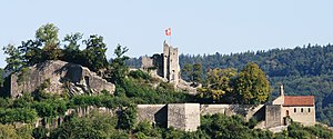
Stein Castle, Aargau
Distance: Approx. 1349 meters
Latitude and longitude: 47.47316111,8.30545
Stein Castle (German: Schloss Stein or Ruine Stein) is a castle ruin above the municipality of Baden in the canton of Aargau in Switzerland. It is a Swiss heritage site of national significance.

Wettingen railway station
Railway station in Switzerland
Distance: Approx. 605 meters
Latitude and longitude: 47.45961111,8.316
Wettingen railway station (German: Bahnhof Wettingen) is a railway station in the municipality of Wettingen in the Swiss canton of Aargau. The station is located on the Zürich to Baden main line, just west of the point where the Furttal line joins the main line.
Schräglift Webermühle
Inclined elevator in Wettingen, Aargau, Switzerland
Distance: Approx. 618 meters
Latitude and longitude: 47.458241,8.315261
Schräglift Webermühle is an inclined lift at Limmat river in Wettingen, Aargau, Switzerland. The lift connects the Webermühle residential area in Neuenhof to the Wettingen railway station above. It has a difference of elevation of 20 m.
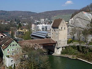
Landvogtei Castle of Baden
Distance: Approx. 1332 meters
Latitude and longitude: 47.473039,8.310919
Landvogtei Castle (Landvogteischloss) is a small castle in the city of Baden in the Swiss canton of Aargau. It is located on the right bank of the Limmat River opposite the old town and once guarded the narrows between the Schlossberg to the west (with Stein Castle) and the Lägern to the east. Until 1798 it was the residence of the bailiff of the county of Baden.
Weather in this IP's area
light intensity shower rain
19 Celsius
19 Celsius
18 Celsius
20 Celsius
1009 hPa
89 %
1009 hPa
965 hPa
10000 meters
0.51 m/s
40 %
06:55:18
19:53:46