Country:
 Switzerland
Region:
City:
Latitude and Longitude:
Time Zone:
Postal Code:
IP information under different IP Channel
ip-api
Country
Region
City
ASN
Time Zone
ISP
Blacklist
Proxy
Latitude
Longitude
Postal
Route
IPinfo
Country
Region
City
ASN
Time Zone
ISP
Blacklist
Proxy
Latitude
Longitude
Postal
Route
MaxMind
Country
Region
City
ASN
Time Zone
ISP
Blacklist
Proxy
Latitude
Longitude
Postal
Route
Luminati
Country
CHASN
Time Zone
Europe/Zurich
ISP
green.ch AG
Latitude
Longitude
Postal
db-ip
Country
Region
City
ASN
Time Zone
ISP
Blacklist
Proxy
Latitude
Longitude
Postal
Route
ipdata
Country
Region
City
ASN
Time Zone
ISP
Blacklist
Proxy
Latitude
Longitude
Postal
Route
Popular places and events near this IP address
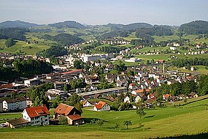
Herisau
Municipality in Appenzell Ausserrhoden, Switzerland
Distance: Approx. 3257 meters
Latitude and longitude: 47.38333333,9.26666667
Herisau is a municipality and the capital of the canton of Appenzell Ausserrhoden in Switzerland. It is the seat of the canton's government and parliament; the judicial authorities are situated in Trogen. The central hamlet and the houses around the central square, the Protestant church of 1580, the houses Wetter and zur Rose (both 1737), the hamlet Schwänberg and the government building with the state archive are listed as heritage sites of national significance.

Schwellbrunn
Municipality in Appenzell Ausserrhoden, Switzerland
Distance: Approx. 2412 meters
Latitude and longitude: 47.35,9.25
Schwellbrunn is a municipality in the canton of Appenzell Ausserrhoden in Switzerland.
Hundwil
Municipality in Appenzell Ausserrhoden, Switzerland
Distance: Approx. 2964 meters
Latitude and longitude: 47.36666667,9.31666667
Hundwil is a municipality in the canton of Appenzell Ausserrhoden in Switzerland.
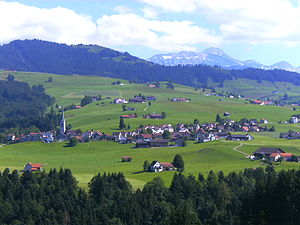
Waldstatt
Municipality in Appenzell Ausserrhoden, Switzerland
Distance: Approx. 662 meters
Latitude and longitude: 47.35,9.28333333
Waldstatt is a municipality in the canton of Appenzell Ausserrhoden in Switzerland.

Hundwiler Höhi
Mountain in Switzerland
Distance: Approx. 4290 meters
Latitude and longitude: 47.34083333,9.33333333
The Hundwiler Höhi (1,306 m) is a mountain of the Appenzell Alps, located on the border between the Swiss cantons of Appenzell Ausserrhoden and Appenzell Innerrhoden. It is situated between Hundwil and Gonten. The summit is easily accessible from every side of the mountain and is a popular vantage point over the Säntis, the Alpstein massif and Lake Constance.

Rosenburg Castle (Ramsenberg)
Swiss castle ruin
Distance: Approx. 4141 meters
Latitude and longitude: 47.3883,9.2544
Rosenburg Castle is a ruined castle located to the west of the municipality of Herisau in the canton of Appenzell Ausserrhoden in Switzerland. It is a Swiss heritage site of national significance. The castle is on the Ramsenstock (926 m (3,038 ft)) and is therefore also called Ramsenburg.
Hinterland, Switzerland
District in Switzerland
Distance: Approx. 1377 meters
Latitude and longitude: 47.3457,9.2701
Hinterland District is one of districts of the Canton of Appenzell Ausserrhoden, Switzerland.
Wilen railway station
Railway station in Herisau, Appenzell Ausserrhoden, Switzerland
Distance: Approx. 2229 meters
Latitude and longitude: 47.37569444,9.27930556
Wilen railway station (German: Bahnhof Wilen), also known as Herisau Wilen, is a railway station in the municipality of Herisau, in the Swiss canton of Appenzell Ausserrhoden. It is located on the 1,000 mm (3 ft 3+3⁄8 in) metre gauge Gossau–Wasserauen line of Appenzell Railways.

Herisau railway station
Train station in Switzerland
Distance: Approx. 3852 meters
Latitude and longitude: 47.39019444,9.27680556
Herisau railway station (German: Bahnhof Herisau) is a railway station in Herisau, in the Swiss canton of Appenzell Ausserrhoden. It is an intermediate station on the 1,435 mm (4 ft 8+1⁄2 in) standard gauge Bodensee–Toggenburg line of Südostbahn and the 1,000 mm (3 ft 3+3⁄8 in) metre gauge Gossau–Wasserauen line of Appenzell Railways. Both companies have separate tracks and facilities, separated by Bahnhofplatz.

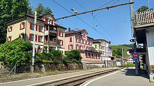
Waldstatt railway station
Train station in Switzerland
Distance: Approx. 444 meters
Latitude and longitude: 47.3575,9.28611111
Waldstatt railway station (German: Bahnhof Waldstatt) is a railway station in the municipality of Waldstatt, in the Swiss canton of Appenzell Ausserrhoden. It is located on the 1,000 mm (3 ft 3+3⁄8 in) metre gauge Gossau–Wasserauen line of Appenzell Railways.

Zürchersmühle railway station
Train station in Switzerland
Distance: Approx. 2979 meters
Latitude and longitude: 47.33019444,9.29280556
Zürchersmühle railway station (German: Bahnhof Zürchersmühle) is a railway station in the municipality of Urnäsch, in the Swiss canton of Appenzell Ausserrhoden. It is located on the 1,000 mm (3 ft 3+3⁄8 in) metre gauge Gossau–Wasserauen line of Appenzell Railways.

Urnäsch railway station
Train station in Switzerland
Distance: Approx. 4233 meters
Latitude and longitude: 47.31780556,9.2855
Urnäsch railway station (German: Bahnhof Urnäsch) is a railway station in the municipality of Urnäsch, in the Swiss canton of Appenzell Ausserrhoden. It is located on the 1,000 mm (3 ft 3+3⁄8 in) metre gauge Gossau–Wasserauen line of Appenzell Railways.
Weather in this IP's area
overcast clouds
7 Celsius
6 Celsius
5 Celsius
9 Celsius
1017 hPa
90 %
1017 hPa
921 hPa
10000 meters
1.58 m/s
1.4 m/s
173 degree
100 %
07:47:16
18:27:59