Country:
 Switzerland
Region:
City:
Latitude and Longitude:
Time Zone:
Postal Code:
IP information under different IP Channel
ip-api
Country
Region
City
ASN
Time Zone
ISP
Blacklist
Proxy
Latitude
Longitude
Postal
Route
IPinfo
Country
Region
City
ASN
Time Zone
ISP
Blacklist
Proxy
Latitude
Longitude
Postal
Route
MaxMind
Country
Region
City
ASN
Time Zone
ISP
Blacklist
Proxy
Latitude
Longitude
Postal
Route
Luminati
Country
CHASN
Time Zone
Europe/Zurich
ISP
green.ch AG
Latitude
Longitude
Postal
db-ip
Country
Region
City
ASN
Time Zone
ISP
Blacklist
Proxy
Latitude
Longitude
Postal
Route
ipdata
Country
Region
City
ASN
Time Zone
ISP
Blacklist
Proxy
Latitude
Longitude
Postal
Route
Popular places and events near this IP address
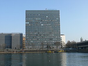
Novartis
Swiss multinational pharmaceutical corporation
Distance: Approx. 214 meters
Latitude and longitude: 47.5744252,7.5764914
Novartis AG is a Swiss multinational pharmaceutical corporation based in Basel, Switzerland. Consistently ranked in the global top five, Novartis is one of the largest pharmaceutical companies in the world and was the fourth largest by revenue in 2022. Novartis manufactures the drugs clozapine (Clozaril), diclofenac (Voltaren; sold to GlaxoSmithKline in 2015 deal), carbamazepine (Tegretol), valsartan (Diovan), imatinib mesylate (Gleevec/Glivec), cyclosporine (Neoral/Sandimmune), letrozole (Femara), methylphenidate (Ritalin; production ceased 2020), terbinafine (Lamisil), deferasirox (Exjade), and others.

Saint-Louis, Haut-Rhin
Commune in Grand Est, France
Distance: Approx. 1594 meters
Latitude and longitude: 47.59,7.57
Saint-Louis (French pronunciation: [sɛ̃ lwi] ; Alsatian: Sä-Louis; German: Sankt Ludwig) is a commune in the Haut-Rhin department in Alsace in north-eastern France. The inhabitants are called Ludoviciens.
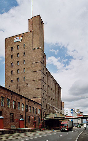
Silo Tower Basel
Distance: Approx. 1398 meters
Latitude and longitude: 47.58361111,7.59
The Silo Tower of Basel is located in the Swiss city of Basel, in the Rhine harbour of Kleinhueningen, near the Dreiländereck. The silo tower was built in 1923 by a Swiss shipping company. Its viewing platform stands at a height of 52 metres (about 160 feet), which offers a view of the Rhine, the Rhine harbour, the city of Basel, and the Sundgauer hill country.

Wiese (river)
A tributary of the Rhine in the southern Black Forest
Distance: Approx. 1160 meters
Latitude and longitude: 47.58278,7.58694
The Wiese is a river, 57.8 kilometres long, and a right-hand tributary of the Rhine in southwest Germany and northwest Switzerland. From its source in Baden-Württemberg in the Southern Black Forest on the mountain of the Feldberg, it flows for a short distance though the county of Breisgau-Hochschwarzwald and then mainly across Lörrach and through numerous settlements including the county town of Lörrach. After crossing the international border, the lower reaches of the river pass through the canton of Basel-Stadt, mainly through the city of Basel and through its district of Kleinbasel before emptying into the Upper Rhine.

Skulpturhalle Basel
Distance: Approx. 1776 meters
Latitude and longitude: 47.5604,7.5793
The Skulpturhalle Basel is a museum in Basel, Switzerland, featuring cast replicas of antique sculpture. With around 2,000 casts, it is the largest collection of its kind in the country, due to its tripling in size between 1985 and 2010. Since 1961, the collection has been managed by the Antikenmuseum Basel.

Basel St. Johann railway station
Railway station in Switzerland
Distance: Approx. 674 meters
Latitude and longitude: 47.57029306,7.57252389
Basel St. Johann railway station (German: Bahnhof Basel St. Johann, French: Gare de Bâle-Saint-Jean) is a railway station in inner-city Basel, Switzerland.
Induced seismicity in Basel
Distance: Approx. 1869 meters
Latitude and longitude: 47.5854,7.5958
Induced seismicity in Basel led to suspension of its hot dry rock enhanced geothermal systems project. A seismic-hazard evaluation was then conducted, resulting in the cancellation of the project in December 2009. Basel, Switzerland sits atop a historically active fault and most of the city was destroyed in a magnitude 6.5 earthquake in 1356.

Biozentrum University of Basel
Division of the University of Basel
Distance: Approx. 1397 meters
Latitude and longitude: 47.56416667,7.58083333
Research at the Biozentrum of the University of Basel is dedicated to the central question of how molecules and cells create life − from atom to organism, and from the physics of life to the dynamics of multicellular systems. Accordingly, the scientists at the Biozentrum are active in a wide range of research fields. These disciplines are not strictly separated from each other, but often overlap, thus leading to new questions and collaborations.

University Hospital of Basel
Hospital in Basel, Switzerland
Distance: Approx. 1599 meters
Latitude and longitude: 47.56277778,7.58305556
The University Hospital of Basel (German: Universitätsspital Basel, USB), in Basel, is one of the five university hospitals of Switzerland. Since 1842 it is located in a former palace, the Markgräflerhof. Until 1865 it was called the Bürgerspital (Citizens Hospital).

Dreiländereck (Basel)
Monument marking the tripoint of France, Germany and Switzerland
Distance: Approx. 1768 meters
Latitude and longitude: 47.5885,7.5898
The Dreiländereck is a monument in Basel, Switzerland. It marks the tripoint where the borders of France, Germany and Switzerland meet. The France–Germany border, the Germany–Switzerland border and France–Switzerland border meet there.
University Children's Hospital Basel
Hospital
Distance: Approx. 1599 meters
Latitude and longitude: 47.56277778,7.58305556
The University Children’s Hospital Basel (UKBB) is an independent, university-based centre of competence for paediatric and juvenile medicine, as well as for teaching and research." The UKBB exists since 1999. On January 29, 2011, after several years of planning and constructing, the UKBB started operations in its new location at Spitalstrasse 33 in Basel. The colourful front of the building is its landmark.
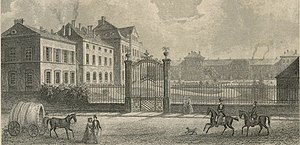
Markgräflerhof
Distance: Approx. 1866 meters
Latitude and longitude: 47.5604,7.5838
The Markgräflerhof is a baroque palace in Basel, Switzerland, built by the margraves of Baden-Durlach, who used it as an extraterritorial residence as their principality including its residences was often the victim of wars and armies. The margraves had several residences in Basel, but the construction of current palace started under margrave Frederick VII in 1698 when a fire destroyed the previous building. The palace was ready to moved in by 1705.
Weather in this IP's area
clear sky
20 Celsius
20 Celsius
19 Celsius
22 Celsius
1012 hPa
73 %
1012 hPa
982 hPa
10000 meters
1.54 m/s
40 degree
06:58:08
19:56:49