Country:
 Switzerland
Region:
City:
Latitude and Longitude:
Time Zone:
Postal Code:
IP information under different IP Channel
ip-api
Country
Region
City
ASN
Time Zone
ISP
Blacklist
Proxy
Latitude
Longitude
Postal
Route
IPinfo
Country
Region
City
ASN
Time Zone
ISP
Blacklist
Proxy
Latitude
Longitude
Postal
Route
MaxMind
Country
Region
City
ASN
Time Zone
ISP
Blacklist
Proxy
Latitude
Longitude
Postal
Route
Luminati
Country
CHASN
Time Zone
Europe/Zurich
ISP
green.ch AG
Latitude
Longitude
Postal
db-ip
Country
Region
City
ASN
Time Zone
ISP
Blacklist
Proxy
Latitude
Longitude
Postal
Route
ipdata
Country
Region
City
ASN
Time Zone
ISP
Blacklist
Proxy
Latitude
Longitude
Postal
Route
Popular places and events near this IP address

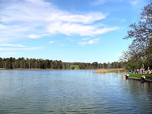
Katzensee
Distance: Approx. 1969 meters
Latitude and longitude: 47.4325,8.49277778
Katzensee is a lake on the border of the city of Zürich and Regensdorf in the Canton of Zürich, Switzerland. Its surface area is 36 ha (89 acres). There is also a public bath/lido Strandbad Katzensee on its southern shore.

Affoltern (Zürich)
Distance: Approx. 806 meters
Latitude and longitude: 47.41861111,8.50611111
Affoltern is a quarter in district 11 in Zürich, located in the Glatt Valley (German: Glattal).
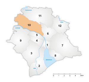
District 10 (Zürich)
District in Zurich, Switzerland
Distance: Approx. 2089 meters
Latitude and longitude: 47.407,8.5
District 10 is a district in the Swiss city of Zurich. The district comprises the quarters Wipkingen and Höngg. Both entities were formerly municipalities of their own but were incorporated into Zurich in 1893 and 1934, respectively.

District 11 (Zürich)
District in Zürich, Switzerland
Distance: Approx. 472 meters
Latitude and longitude: 47.423,8.521
District 11 is the most northern and the most populous district in the Swiss city of Zürich. The district comprises the quarters Affoltern, Oerlikon and Seebach. All three were formerly municipalities in their own right, but were incorporated into Zürich in 1934.

Käferberg
Summits of a wooded mountain
Distance: Approx. 1999 meters
Latitude and longitude: 47.40533,8.52021
Käferberg (el. 571 metres or 1,873 feet) and Waidberg (el. 601 metres or 1,972 feet) are the summits of a wooded range of hills overlooking the inner city of Zürich, Zürichsee, Albis chain and Uetliberg, as well as the Limmat Valley and the Zürcher Unterland in Switzerland.
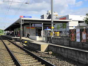
Zurich Affoltern railway station
Railway station in the Affoltern quarter of the Swiss city of Zürich
Distance: Approx. 512 meters
Latitude and longitude: 47.42088889,8.50861111
Zürich Affoltern railway station (German: Bahnhof Zürich Affoltern) is a railway station in the Affoltern quarter of the Swiss city of Zürich. The station is located on the Wettingen–Effretikon railway line (Furttal line). The station is not to be confused with Affoltern am Albis railway station, which is located in Affoltern am Albis (Säuliamt), canton of Zürich.

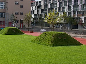
Oerliker Park
Distance: Approx. 1979 meters
Latitude and longitude: 47.41472222,8.53805556
The Oerliker Park is a public multi-purpose district park covering 188,000 square feet (17,500 m2) in Oerlikon, just to the north of Zürich. The Oerliker Park was created by the Grün Stadt Zürich in 2001 as part of the regional development project "Zentrum Zürich Nord" and was the first of four parks. The MFO-Park (2002), the Louis-Häfliger-Park (2003) and the Wahlenpark (2005) were built close-by, each of which are matched to local needs as district- and neighbourhood-parks, as well as playgrounds.
Louis-Häfliger-Park
Distance: Approx. 1850 meters
Latitude and longitude: 47.4125,8.53388889
The Louis-Häfliger-Park in Oerlikon, Zurich, covers 5,000 m2 (53,820 sq ft) and is embedded between the Regina-Kägi-Hof co-operative settlement, the existing production buildings for Oerlikon-Contraves AG, and new service buildings. It is a neighbourhood park allowing people who live or work here to relax and meet. The park is named after Louis Häfliger (1904–1993), "Saviour of Mauthausen".

Wahlenpark
Public park in New Oerlikon in Zurich
Distance: Approx. 2137 meters
Latitude and longitude: 47.41583333,8.54111111
The Wahlenpark is a public park in New Oerlikon in the northern part of Zurich. The park covers 139,931 ft². It was created in 2005 as part of the regional development "Zentrum Zürich Nord", as the last of four parks.

Gustav-Ammann-Park
Public park in Oerlikon, Zurich
Distance: Approx. 1961 meters
Latitude and longitude: 47.41138889,8.53444444
The Gustav-Ammann-Park is a public park in Oerlikon, Zurich on the former premises of Oerlikon-Bührle and covers 32,291 ft2. In 1996, the privately owned park became a preserve. One year later, the formerly nameless facility was handed over to the population as Gustav-Ammann-Park.

Kantonsschule Zürich Nord
Distance: Approx. 2235 meters
Latitude and longitude: 47.4083,8.5351
Kantonsschule Zürich Nord (KZN) is a Swiss cantonal gymnasium (Langzeit-, Kurzzeit, und Fachmittelschule) in Oerlikon, northern Zürich, Switzerland. The school, which first opened in 2012, was formed by the merger of Kantonsschule Zürich Birch and Kantonsschule Oerlikon (see German WP).
Seebad Katzensee
Distance: Approx. 1870 meters
Latitude and longitude: 47.431238,8.493173
Seebad Katzensee (Strandbad is commonly used, while Seebad is the "official" name) is a public bath in the Swiss municipalities of Zürich-Affoltern and Regensdorf.
Weather in this IP's area
fog
10 Celsius
10 Celsius
9 Celsius
12 Celsius
1018 hPa
96 %
1018 hPa
963 hPa
8000 meters
2.06 m/s
170 degree
75 %
07:50:26
18:30:56