Country:
 Switzerland
Region:
City:
Latitude and Longitude:
Time Zone:
Postal Code:
IP information under different IP Channel
ip-api
Country
Region
City
ASN
Time Zone
ISP
Blacklist
Proxy
Latitude
Longitude
Postal
Route
IPinfo
Country
Region
City
ASN
Time Zone
ISP
Blacklist
Proxy
Latitude
Longitude
Postal
Route
MaxMind
Country
Region
City
ASN
Time Zone
ISP
Blacklist
Proxy
Latitude
Longitude
Postal
Route
Luminati
Country
CHASN
Time Zone
Europe/Zurich
ISP
green.ch AG
Latitude
Longitude
Postal
db-ip
Country
Region
City
ASN
Time Zone
ISP
Blacklist
Proxy
Latitude
Longitude
Postal
Route
ipdata
Country
Region
City
ASN
Time Zone
ISP
Blacklist
Proxy
Latitude
Longitude
Postal
Route
Popular places and events near this IP address
Emmen, Switzerland
Municipality in Lucerne, Switzerland
Distance: Approx. 1323 meters
Latitude and longitude: 47.08333333,8.3
Emmen is a village and municipality in the district of Hochdorf in the canton of Lucerne in Switzerland. The municipality Emmen consists of the village Emmen, the town Emmenbrücke, and several hamlets.

Rotsee
Distance: Approx. 2717 meters
Latitude and longitude: 47.06972222,8.31416667
The Rotsee (previously known as Rootsee) is a natural rowing lake on the northern edge of Lucerne, Switzerland. It is regarded as one of the best rowing venues in the world.
Buchrain
Municipality in Lucerne, Switzerland
Distance: Approx. 3237 meters
Latitude and longitude: 47.1,8.35
Buchrain is a municipality in the district of Lucerne in the canton of Lucerne in Switzerland.

Ebikon
Municipality in Lucerne, Switzerland
Distance: Approx. 2228 meters
Latitude and longitude: 47.08333333,8.33333333
Ebikon is a municipality in the district of Lucerne in the canton of Lucerne in Switzerland.

Rothenburg, Lucerne
Municipality in Lucerne, Switzerland
Distance: Approx. 3227 meters
Latitude and longitude: 47.1,8.26666667
Rothenburg (High Alemannic: Rooteborg) is a municipality in the district of Hochdorf in the canton of Lucerne in Switzerland.
Stadion Gersag
Distance: Approx. 2439 meters
Latitude and longitude: 47.07972222,8.28361111
Stadion Gersag is a stadium in Emmenbrücke, Luzern, Switzerland. It is currently used for football matches and is the home ground of FC Emmenbrücke. The stadium has 3,195 covered seats and 4,785 standing places.

Emmen Air Base
Airport
Distance: Approx. 339 meters
Latitude and longitude: 47.09222222,8.30444444
Militärflugplatz Emmen (Emmen Military Air Base) (IATA: EML, ICAO: LSME) is a military airfield of the Swiss Air Force north of Emmen, Switzerland, located northwest of Lucerne.

Emmenbrücke railway station
Swiss railway station
Distance: Approx. 3059 meters
Latitude and longitude: 47.0725,8.28277778
Emmenbrücke railway station (German: Bahnhof Emmenbrücke) is a railway station in the municipality of Emmen, in the Swiss canton of Lucerne. It is an intermediate stop on the standard gauge Olten–Lucerne and Seetal lines of Swiss Federal Railways.
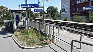
Emmenbrücke Gersag railway station
Swiss railway station
Distance: Approx. 2944 meters
Latitude and longitude: 47.07831194,8.27679
Emmenbrücke Gersag railway station (German: Bahnhof Emmenbrücke Gersag) is a railway station in the municipality of Emmen, in the Swiss canton of Lucerne. It is located at the junction of the standard gauge Olten–Lucerne and Seetal lines of Swiss Federal Railways.
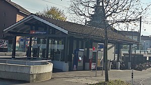
Emmenbrücke Kapf railway station
Swiss railway station
Distance: Approx. 2718 meters
Latitude and longitude: 47.09027778,8.27277778
Emmenbrücke Kapf railway station (German: Bahnhof Emmenbrücke Kapf) is a railway station in the municipality of Emmen, in the Swiss canton of Lucerne. It is an intermediate stop on the standard gauge Olten–Lucerne line of Swiss Federal Railways. Until the December 2022 timetable change, the station was named Rothenburg Dorf, after the nearby municipality of Rothenburg.

Ebikon railway station
Swiss railway station
Distance: Approx. 2793 meters
Latitude and longitude: 47.08426306,8.34235806
Ebikon railway station (German: Bahnhof Ebikon) is a railway station in the municipality of Ebikon, in the Swiss canton of Lucerne. It is an intermediate stop on the standard gauge Zug–Lucerne line of Swiss Federal Railways.

Waldibrücke railway station
Swiss railway station
Distance: Approx. 1791 meters
Latitude and longitude: 47.10788889,8.31968056
Waldibrücke railway station (German: Bahnhof Waldibrücke) is a railway station in the municipality of Emmen, in the Swiss canton of Lucerne. It is an intermediate stop on the standard gauge Seetal line of Swiss Federal Railways.
Weather in this IP's area
broken clouds
10 Celsius
10 Celsius
9 Celsius
11 Celsius
1018 hPa
90 %
1018 hPa
967 hPa
10000 meters
1.19 m/s
1.12 m/s
190 degree
84 %
07:50:47
18:32:15