193.67.43.143 - IP Lookup: Free IP Address Lookup, Postal Code Lookup, IP Location Lookup, IP ASN, Public IP
Country:
Region:
City:
Location:
Time Zone:
Postal Code:
IP information under different IP Channel
ip-api
Country
Region
City
ASN
Time Zone
ISP
Blacklist
Proxy
Latitude
Longitude
Postal
Route
Luminati
Country
ASN
Time Zone
Europe/Amsterdam
ISP
UUNET
Latitude
Longitude
Postal
IPinfo
Country
Region
City
ASN
Time Zone
ISP
Blacklist
Proxy
Latitude
Longitude
Postal
Route
IP2Location
193.67.43.143Country
Region
zuid-holland
City
voorschoten
Time Zone
Europe/Amsterdam
ISP
Language
User-Agent
Latitude
Longitude
Postal
db-ip
Country
Region
City
ASN
Time Zone
ISP
Blacklist
Proxy
Latitude
Longitude
Postal
Route
ipdata
Country
Region
City
ASN
Time Zone
ISP
Blacklist
Proxy
Latitude
Longitude
Postal
Route
Popular places and events near this IP address

Voorschoten
Town and Municipality in South Holland, Netherlands
Distance: Approx. 656 meters
Latitude and longitude: 52.13333333,4.45
Voorschoten (Dutch pronunciation: [ˈvoːrsxoːtə(n)] ) is a town and municipality in the western Netherlands, in the province of South Holland. It is a smaller town in the Randstad, enclosed by the cities of Leiden, Wassenaar and Leidschendam-Voorburg. The municipality covers an area of 11.56 km2 (4.46 sq mi) of which 0.42 km2 (0.16 sq mi) is covered by water.

De Vink railway station
Railway station in the Netherlands
Distance: Approx. 2135 meters
Latitude and longitude: 52.14583333,4.45777778
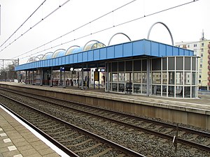
De Vink is a railway station in the Netherlands. It is located near the former hamlet of De Vink, currently a part of Leiden. The station re-opened in 1985.

Zoeterwoude-Dorp
Town in South Holland, Netherlands
Distance: Approx. 3414 meters
Latitude and longitude: 52.11916667,4.49666667
Zoeterwoude-Dorp is a town in the Dutch province of South Holland. It is a part of the municipality of Zoeterwoude, and lies about 3.5 km south of Leiden. It has its origins in the 13th century, and even though the whole town went up in flames in the late 16th century, it was rebuilt within a hundred years and significantly expanded over the course of the 20th century.

Westeinde, Zoeterwoude
Village in South Holland, Netherlands
Distance: Approx. 2915 meters
Latitude and longitude: 52.11472222,4.48583333
Westeinde is a village in the Dutch province of South Holland. It is a part of the municipality of Zoeterwoude, and lies about 6 km north of Zoetermeer. The statistical area "Westeinde", which also can include the surrounding countryside, has a population of around 110.

Stompwijk
Place in South Holland, Netherlands
Distance: Approx. 3301 meters
Latitude and longitude: 52.1,4.46666667
Stompwijk is a village in the Dutch province of South Holland. It is located between the cities Leiden and Zoetermeer and is part of the municipality of Leidschendam-Voorburg. Stompwijk was a separate municipality between 1817 and 1938, when it merged with Veur to create the new municipality of Leidschendam.
American School of The Hague
Private international school in Wassenaar, Netherlands
Distance: Approx. 2746 meters
Latitude and longitude: 52.14611111,4.42222222
The American School of The Hague is an international school located in Wassenaar, Netherlands. Student enrollment age ranges from 3 to 18 years. It represents students from 80 different countries, with 28% and 15% being American and Dutch nationals.
Voorschoten railway station
Railway station in Voorschoten, South Holland, Netherlands
Distance: Approx. 1013 meters
Latitude and longitude: 52.12638889,4.43388889
Voorschoten is a railway station in Voorschoten, South Holland, Netherlands.
Vijf Meihal
Dutch arena
Distance: Approx. 3072 meters
Latitude and longitude: 52.14919444,4.47638889
The Vijf Meihal (English: 5 May Hall) is a now-closed sports complex located in the Dutch city of Leiden. It was used as a sports arena since 1968, as the former home base of professional basketball club ZZ Leiden, who used it up until 2024 when they moved to the Sportcomplex 1574.
ZZ Leiden
Dutch basketball club
Distance: Approx. 3072 meters
Latitude and longitude: 52.14919444,4.47638889
ZZ Leiden Basketball, also known as Zorg en Zekerheid Leiden, is a professional basketball club based in Leiden, Netherlands. The club plays in the BNXT League, the domestic first tier league. Their home games are played at Sportcomplex 1574.

2023 Voorschoten train crash
Rail accident in South Holland, Netherlands
Distance: Approx. 1432 meters
Latitude and longitude: 52.1228,4.4291
On 4 April 2023, a freight train and a passenger train collided with construction equipment obstructing the line at Voorschoten, South Holland, Netherlands. The passenger train was derailed. The operator of the crane was killed and 30 people were injured, 19 of whom were hospitalized.

1926 Voorschoten train crash
Rail accident in South Holland, Netherlands
Distance: Approx. 2135 meters
Latitude and longitude: 52.14583333,4.45777778
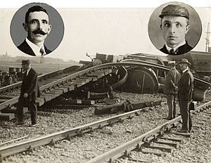
On 9 September 1926, a passenger train was derailed near Voorschoten, Netherlands due to defective track. Four people were killed and 30 were injured.

Rosenburgh Castle
Castle in the Netherlands
Distance: Approx. 1664 meters
Latitude and longitude: 52.118822,4.42877
Rosenburgh Castle or Rosenburg was a castle located in today's Voorschoten, the Netherlands. In the early 1700s, it was replaced by a manor which was demolished only a few years after its construction. Rosenburgh Castle was the center of a significant siege in 1351.
Weather in this IP's area
few clouds
4 Celsius
3 Celsius
3 Celsius
5 Celsius
1023 hPa
89 %
1023 hPa
1023 hPa
10000 meters
1.54 m/s
200 degree
20 %
