Country:
 Belgium
Region:
City:
Latitude and Longitude:
Time Zone:
Postal Code:
IP information under different IP Channel
ip-api
Country
Region
City
ASN
Time Zone
ISP
Blacklist
Proxy
Latitude
Longitude
Postal
Route
IPinfo
Country
Region
City
ASN
Time Zone
ISP
Blacklist
Proxy
Latitude
Longitude
Postal
Route
MaxMind
Country
Region
City
ASN
Time Zone
ISP
Blacklist
Proxy
Latitude
Longitude
Postal
Route
Luminati
Country
BEASN
Time Zone
Europe/Brussels
ISP
BELNET
Latitude
Longitude
Postal
db-ip
Country
Region
City
ASN
Time Zone
ISP
Blacklist
Proxy
Latitude
Longitude
Postal
Route
ipdata
Country
Region
City
ASN
Time Zone
ISP
Blacklist
Proxy
Latitude
Longitude
Postal
Route
Popular places and events near this IP address

Vrije Universiteit Brussel
University in Brussels, Belgium
Distance: Approx. 241 meters
Latitude and longitude: 50.82242,4.39573
The Vrije Universiteit Brussel (Dutch: [ˈvrɛiə ʔynivɛrsiˈtɛid ˈbrʏsəl] ; lit. Free University of Brussels; abbreviated VUB) is a Dutch and English-speaking research university in Brussels, Belgium. It has four campuses: Brussels Humanities, Science and Engineering Campus (in Elsene), Brussels Health Campus (in Jette), Brussels Technology Campus (in Anderlecht) and Brussels Photonics Campus (in Gooik).
Vesalius College
Liberal arts college in Brussels, Belgium
Distance: Approx. 445 meters
Latitude and longitude: 50.8245,4.3984
Vesalius College, also known as VeCo, is a private college located in Brussels, Belgium. Founded in 1987, it is named after Andreas Vesalius, a pioneering anatomist of the Renaissance period. The college is associated with the Vrije Universiteit Brussel (VUB) and has been part of the Brussels School of Governance, since February 2021, through an alliance with VUB's Institute for European Studies.

Ixelles Cemetery
Cemetery in Ixelles, Belgium
Distance: Approx. 902 meters
Latitude and longitude: 50.815,4.39194444
Ixelles Cemetery (French: Cimetière d'Ixelles, pronounced [sim.tjɛʁ dik.sɛl]; Dutch: Begraafplaats van Elsene), located in Ixelles in the southern part of Brussels, is one of the major cemeteries in Belgium. Ixelles Cemetery also refers to a neighbourhood with a lot of bars and restaurants for students, north of the actual cemetery. It is in fact located between the two main campuses (Solbosch and La Plaine) of the Université libre de Bruxelles (ULB).
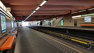
Delta station
Railway and metro station in Brussels, Belgium
Distance: Approx. 979 meters
Latitude and longitude: 50.81833333,4.40416667
Delta is a railway and metro station in the municipality of Auderghem, in the south-eastern part of Brussels, Belgium. It is located near the intersection of the Boulevard du Triomphe/Triomflaan and the Boulevard des Invalides/Invalidenlaan and provides access to the adjacent Plaine campus of the Université libre de Bruxelles (ULB) and to the Etterbeek campus of the Vrije Universiteit Brussel (VUB). The station was inaugurated on 20 September 1976, as part of the first heavy metro segment of the network, located on the branch from Merode to Beaulieu.
Boston University Brussels
Distance: Approx. 933 meters
Latitude and longitude: 50.81739,4.402176
Boston University Brussels, officially named the Boston University Brussels Graduate Center, and also known as BUB, was part of Boston University's Metropolitan College (MET), one of seventeen degree-granting colleges that make up Boston University. In 1972 Boston University became the first major American university to offer graduate business management degrees in Europe with the opening of its campus in Brussels, Belgium. Due to its location in the unofficial capital of Europe, home to the European Union and NATO, the school placed a strong emphasis on international business, and the student body comprised a diverse range of nationalities and cultures.
20 km of Brussels
20 km running race held every year in Brussels, Belgium
Distance: Approx. 881 meters
Latitude and longitude: 50.8214,4.4047
The 20 km of Brussels (French: 20 km de Bruxelles, Dutch: 20 km door Brussel) is a 20.1 km running race that has been held each year in Brussels since 1980, usually in May. It used to have a maximum number of 25,000 entries, which were normally sold out quite quickly after places go on sale in March, but in 2010 a staggered start-time approach led to an increased maximum number of entries of 40,000. The race is a major event in Brussels, with a large turnout of supporters.
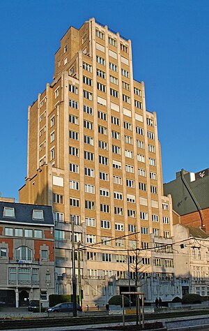
Résidence de la Cambre
First high-rise building in Brussels, Belgium
Distance: Approx. 1202 meters
Latitude and longitude: 50.81731389,4.37803333
The Résidence de la Cambre is the first high-rise building constructed in Brussels, Belgium. It was built in 1938–39, according to the plans of the architect Marcel Peeters, in a style inspired by New York Art Deco architecture. The 17-story residential tower was listed as a protected monument on 14 July 2005.

Pétillon metro station
Metro station in Brussels, Belgium
Distance: Approx. 927 meters
Latitude and longitude: 50.82694444,4.40416667
Pétillon is a Brussels Metro station on the eastern branch of line 5. It is located in the municipality of Etterbeek, in the eastern part of Brussels, Belgium. The metro station opened on 20 September 1976 and is named after Major Pétillon, a Belgian colonial pioneer who died in Etterbeek in 1909.

Hankar metro station
Metro station in Brussels, Belgium
Distance: Approx. 934 meters
Latitude and longitude: 50.82166667,4.40555556
Hankar is a Brussels Metro station on the eastern branch of line 5. It is located in the municipality of Auderghem, in the south-eastern part of Brussels, Belgium. It is named after the Square Baron Robert Hankar/Baron Robert Hankarsquare.

Etterbeek railway station
Railway station in Brussels, Belgium
Distance: Approx. 234 meters
Latitude and longitude: 50.82222222,4.38944444
Etterbeek railway station (French: Gare d'Etterbeek; Dutch: Station Etterbeek) is a railway station in Brussels, Belgium, operated by the National Railway Company of Belgium (NMBS/SNCB). The station is named after the municipality of Etterbeek, though it is located in neighbouring Ixelles, at the Couronne/Kroon crossroad on the Greater Ring. It first opened in 1880, and was, as of 2007, the 29th most used railway station in Belgium, with 5,565 passengers per day.
Institut Saint-André
Independent mixed primary and secondary school in Brussels, Belgium
Distance: Approx. 1061 meters
Latitude and longitude: 50.819444,4.378542
Institut Saint-André is a French speaking Catholic free school ("ecole libre" - a subsidized state school in Belgium), situated in Ixelles, Brussels, Belgium. Commonly called "Saint-André" by students, it is composed of two campuses. The primary and "maternelle" (preschool) share a site on Chaussée de Boondael, while the secondary school is found on the nearby Avenue de l'Hippodrome.

Sciensano
Belgian national institute
Distance: Approx. 768 meters
Latitude and longitude: 50.824308,4.381724
Sciensano is a research institute and the national public health institute of Belgium. It is a so-called federal scientific institution that operates under the authority of the federal minister of Public Health and the federal minister of Agriculture of Belgium. Sciensano's core business is scientific research in the fields of public health, animal health and food safety.
Weather in this IP's area
few clouds
12 Celsius
11 Celsius
10 Celsius
12 Celsius
1025 hPa
91 %
1025 hPa
1014 hPa
10000 meters
2.06 m/s
250 degree
20 %
07:19:50
19:54:45