Country:
 Belgium
Region:
City:
Latitude and Longitude:
Time Zone:
Postal Code:
IP information under different IP Channel
ip-api
Country
Region
City
ASN
Time Zone
ISP
Blacklist
Proxy
Latitude
Longitude
Postal
Route
IPinfo
Country
Region
City
ASN
Time Zone
ISP
Blacklist
Proxy
Latitude
Longitude
Postal
Route
MaxMind
Country
Region
City
ASN
Time Zone
ISP
Blacklist
Proxy
Latitude
Longitude
Postal
Route
Luminati
Country
BEASN
Time Zone
Europe/Brussels
ISP
BELNET
Latitude
Longitude
Postal
db-ip
Country
Region
City
ASN
Time Zone
ISP
Blacklist
Proxy
Latitude
Longitude
Postal
Route
ipdata
Country
Region
City
ASN
Time Zone
ISP
Blacklist
Proxy
Latitude
Longitude
Postal
Route
Popular places and events near this IP address
Statistics Belgium
Distance: Approx. 98 meters
Latitude and longitude: 50.858225,4.35566944
Statistics Belgium (abbreviated Statbel formerly known as the NSI) is part of the Federal Public Service Economy, SMEs, Self-Employed and Energy. Its legal Dutch name is Algemene Directie Statistiek, and its legal French name is Direction générale Statistique. Statistics Belgium conducts surveys among households and enterprises in Belgium.
State Security Service (Belgium)
Belgian intelligence and security agency
Distance: Approx. 157 meters
Latitude and longitude: 50.85769167,4.35516111
The State Security Service (VSSE) (known in Dutch as Staatsveiligheid; French: Sûreté de l'État) is a Belgian intelligence and security agency. Established in 1830, it is the world's oldest intelligence service. The State Security is a civilian agency under the authority of the Ministry of Justice, while the military intelligence agency, the General Information and Security Service, operates under the authority of the Ministry of Defense.
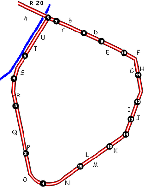
Small Ring, Brussels
Small ring road of Brussels, Belgium
Distance: Approx. 356 meters
Latitude and longitude: 50.85701,4.3525
The Small Ring (French: Petite Ceinture, Dutch: Kleine Ring) inner ring road, formally R20 and N0 is a series of roadways in central Brussels, Belgium, surrounding the historic city centre. The city centre is usually defined as the area within the Small Ring; this area is called the Pentagon due to its pentagonal shape. The pentagon forms the core of the City of Brussels municipality.

Brussels-North railway station
Railway and premetro station in Brussels, Belgium
Distance: Approx. 369 meters
Latitude and longitude: 50.86,4.36166667
Brussels-North railway station (French: Gare de Bruxelles-Nord; Dutch: Station Brussel-Noord) is one of the three major railway stations in Brussels, Belgium; the other two are Brussels-Central and Brussels-South. Every regular domestic and international train (except Eurostar) passing there has a planned stop. The station has 200,000 passengers per week, mainly commuters, making it one of the busiest in Belgium.

Rogier metro station
Metro station in Brussels, Belgium
Distance: Approx. 356 meters
Latitude and longitude: 50.85541667,4.35833333
Rogier is a rapid transit station in Brussels, Belgium, consisting of both a metro station (on the northern segment of lines 2 and 6) and a premetro (underground tram) station (serving lines 4 and 10 on the North–South Axis between Brussels-North railway station and Albert premetro station). It is located under the Small Ring (Brussels' inner ring road) at the Place Charles Rogier/Karel Rogierplein in the municipality of the Saint-Josse-ten-Noode, north of the City of Brussels. The station takes its name from that aboveground square, itself named after Charles Rogier, Belgium's 13th Prime Minister.

Rogier Tower
Skyscraper in Brussels, Belgium
Distance: Approx. 280 meters
Latitude and longitude: 50.85638889,4.35916667
The Rogier Tower (French: Tour Rogier; Dutch: Rogiertoren) is a skyscraper located in the Northern Quarter central business district of Brussels, Belgium. It owes its name to the Place Charles Rogier/Karel Rogierplein on which it is situated. It is the fifth tallest building in Belgium.
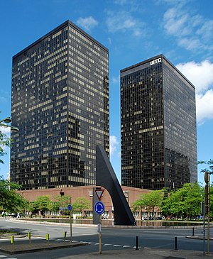
World Trade Center (Brussels)
Complex of skyscrapers in Brussels, Belgium
Distance: Approx. 291 meters
Latitude and longitude: 50.86111111,4.35694444
The World Trade Center (WTC) is a complex of skyscrapers at the corner of the Boulevard du roi Albert II/Koning Albert II-laan and the Boulevard Simon Bolivar/Simon Bolivarlaan in the Northern Quarter central business district of Brussels, Belgium. Its three towers are among the tallest buildings in Belgium. The complex was originally planned to have eight towers, all around the corner of the Boulevard du roi Albert II and the Boulevard Simon Bolivar.

Northern Quarter, Brussels
Central business district in Brussels, Belgium
Distance: Approx. 161 meters
Latitude and longitude: 50.85805556,4.35916667
The Northern Quarter (French: Quartier Nord or Espace Nord; Dutch: Noordwijk or Noordruimte) is the central business district of Brussels, Belgium. Like La Défense in Paris, the Docklands in London or the Zuidas in Amsterdam, the Northern Quarter consists of a concentrated collection of high-rise buildings where many Belgian and multinational companies have their headquarters. The Northern Quarter roughly covers the area between Willebroek Quay, railways along Brussels-North railway station and the northern side of the Small Ring (Brussels' inner ring road).

Proximus Towers
Twin skyscrapers in Brussels, Belgium
Distance: Approx. 166 meters
Latitude and longitude: 50.85972222,4.35833333
The Proximus Towers (French: Tours Proximus; Dutch: Proximustorens) are twin skyscrapers on the Boulevard du roi Albert II/Koning Albert II-laan in the Northern Quarter central business district of Brussels, Belgium. The buildings take their name from the telecommunications company Proximus. They were formerly known as the Belgacom Towers before the company's name change.

North Galaxy Towers
Twin skyscrapers in Brussels, Belgium
Distance: Approx. 356 meters
Latitude and longitude: 50.86138889,4.35916667
The North Galaxy Towers (French: Tours North Galaxy; Dutch: North Galaxytorens) are twin 28-storey skyscrapers on the Boulevard du roi Albert II/Koning Albert II-laan in the Northern Quarter central business district of Brussels, Belgium. There is a third building in the complex which is 6 storeys tall. The first two floors are shared by all three buildings.

Place Charles Rogier
Square in Brussels, Belgium
Distance: Approx. 347 meters
Latitude and longitude: 50.85555556,4.35861111
The Place Charles Rogier (French: [plas ʃaʁl ʁɔ.ʒje]) or Karel Rogierplein (Dutch), usually shortened to the Place Rogier, or Rogier by locals, is a major square in the Brussels municipality of Saint-Josse-ten-Noode, Belgium. It is named in honour of Charles Rogier, a former Prime Minister of Belgium who played a great political role during the Belgian Revolution of 1830. The square is located on the transition between Brussels' historic city centre (the Pentagon) and the Northern Quarter business district (also called Little Manhattan), an exponent of modern Brussels.

Laeken Gate
Former city gate in Brussels, Belgium
Distance: Approx. 300 meters
Latitude and longitude: 50.85611111,4.355
The Laeken Gate (French: Porte de Laeken; Dutch: Lakensepoort) was one of the medieval city gates of the second walls of Brussels, Belgium.
Weather in this IP's area
overcast clouds
16 Celsius
16 Celsius
16 Celsius
16 Celsius
1000 hPa
88 %
1000 hPa
997 hPa
10000 meters
6.78 m/s
12.92 m/s
213 degree
100 %
07:52:49
19:07:31