Country:
Region:
City:
Latitude and Longitude:
Time Zone:
Postal Code:
IP information under different IP Channel
ip-api
Country
Region
City
ASN
Time Zone
ISP
Blacklist
Proxy
Latitude
Longitude
Postal
Route
Luminati
Country
ASN
Time Zone
Europe/Paris
ISP
Aeroport de la Cote d Azur
Latitude
Longitude
Postal
IPinfo
Country
Region
City
ASN
Time Zone
ISP
Blacklist
Proxy
Latitude
Longitude
Postal
Route
db-ip
Country
Region
City
ASN
Time Zone
ISP
Blacklist
Proxy
Latitude
Longitude
Postal
Route
ipdata
Country
Region
City
ASN
Time Zone
ISP
Blacklist
Proxy
Latitude
Longitude
Postal
Route
Popular places and events near this IP address
Saint-Laurent-du-Var
Commune in Provence-Alpes-Côte d'Azur, France
Distance: Approx. 601 meters
Latitude and longitude: 43.668,7.188
Saint-Laurent-du-Var (French pronunciation: [sɛ̃ loʁɑ̃ dy vaʁ]; Occitan: Sant Laurenç de Var, Italian: San Lorenzo del Varo) is a commune in the Alpes-Maritimes department in the Provence-Alpes-Côte d'Azur region on the French Riviera.
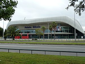
Palais Nikaïa
Multi-purpose indoor facility in Nice, France
Distance: Approx. 1007 meters
Latitude and longitude: 43.67833333,7.20029444
Palais Nikaïa (French pronunciation: [palɛ nikaja]) is an indoor concert hall and multi-purpose facility located in Nice, France. It opened on 4 April 2001, and is located at a five-minute drive from Côte d'Azur International Airport. The name Nikaïa derives from the ancient Greek settlement, predecessor of today's Nice.

Stade Charles-Ehrmann
Distance: Approx. 848 meters
Latitude and longitude: 43.67833333,7.19777778
Stade Charles-Ehrmann is a multi-use stadium in Nice, France. For sporting events it seats 8,000 spectators. It is sometimes used by the OGC Nice, for practice or friendly matches, and by their reserves team the Eaglets.

Jardin botanique de Nice
Distance: Approx. 2091 meters
Latitude and longitude: 43.6851,7.2101
The Jardin botanique de la Ville de Nice (3.5 hectares), also known as the Jardin botanique de Nice, is a municipal botanical garden located at 78 avenue de la Corniche Fleurie, Nice, Alpes-Maritimes, Provence-Alpes-Côte d'Azur, France. It is open daily without charge.
Canton of Saint-Laurent-du-Var-Cagnes-sur-Mer-Est
Former canton in Provence-Alpes-Côte d'Azur, France
Distance: Approx. 594 meters
Latitude and longitude: 43.66805556,7.18805556
The Canton of Saint-Laurent-du-Var-Cagnes-sur-Mer-Est is a former French canton, located in the arrondissement of Grasse, in the Alpes-Maritimes département (Provence-Alpes-Côte d'Azur région). It had 37,102 inhabitants (2012).

Parc Phœnix
Zoo in Alpes-Maritimes, France
Distance: Approx. 1242 meters
Latitude and longitude: 43.66694444,7.20277778
Parc Phœnix is a 7-hectare (17-acre) botanical garden and zoo in Nice, Alpes-Maritimes, France.

1952 Air France SNCASE Languedoc crash
1952 plane crash
Distance: Approx. 1606 meters
Latitude and longitude: 43.66666667,7.20777778
The 1952 Air France SNCASE Languedoc crash occurred on 3 March 1952 when a SNCASE SE.161/P7 Languedoc aircraft of Air France crashed on take-off from Nice Airport for Le Bourget Airport, Paris, killing all 38 people on board. The cause of the accident was that the aileron controls had jammed, which in itself was contributed to by a design fault. The accident was the third-deadliest in France at the time and is the deadliest involving the SNCASE Languedoc.

Canton of Cagnes-sur-Mer-2
Canton in Provence-Alpes-Côte d'Azur, France
Distance: Approx. 1649 meters
Latitude and longitude: 43.67,7.17
The canton of Cagnes-sur-Mer-2 is an administrative division of the Alpes-Maritimes department, southeastern France. It was created at the French canton reorganisation which came into effect in March 2015. Its seat is in Cagnes-sur-Mer.

Canton of Nice-3
Canton in Provence-Alpes-Côte d'Azur, France
Distance: Approx. 1105 meters
Latitude and longitude: 43.68,7.2
The canton of Nice-3 is an administrative division of the Alpes-Maritimes department, southeastern France. Its borders were modified at the French canton reorganisation which came into effect in March 2015. Its seat is in Nice.

Nice-Saint-Augustin station
Distance: Approx. 2142 meters
Latitude and longitude: 43.6708,7.2164
Nice St-Augustin station (French: Gare de Nice St-Agustin) is a train station on the line from Marseille to Ventimiglia, situated in Nice, in the department of Alpes-Maritimes in the region of Provence-Alpes-Côte d'Azur, France.
Saint-Laurent-du-Var station
Distance: Approx. 1250 meters
Latitude and longitude: 43.66245,7.19449
Saint-Laurent-du-Var is a train station on the line from Marseille to Ventimiglia, situated in Saint-Laurent-du-Var, west of Nice, in the department of Alpes-Maritimes in the region of Provence-Alpes-Côte d'Azur, France. The station is located in the vicinity of the CAP 3000, the largest shopping centre in Nice. Numerous bus serves link the station to the Shopping Centre.

Meeting Nikaïa
Distance: Approx. 848 meters
Latitude and longitude: 43.67833333,7.19777778
The Meeting International de Nice "Nikaïa is an annual one-day outdoor track and field meeting at the Stade Charles-Ehrmann in Nice, France. First held on 16 August 1976, it was held in June or July each year until 2001, when the meeting folded due to financial reasons. It was part of the IAAF Grand Prix circuit from 1998 to 2001.
Weather in this IP's area
broken clouds
18 Celsius
18 Celsius
17 Celsius
18 Celsius
1024 hPa
87 %
1024 hPa
1022 hPa
10000 meters
1.54 m/s
250 degree
75 %
07:12:35
17:17:05


