Country:
 Great Britain
Region:
City:
Latitude and Longitude:
Time Zone:
Postal Code:
IP information under different IP Channel
ip-api
Country
Region
City
ASN
Time Zone
ISP
Blacklist
Proxy
Latitude
Longitude
Postal
Route
IPinfo
Country
Region
City
ASN
Time Zone
ISP
Blacklist
Proxy
Latitude
Longitude
Postal
Route
MaxMind
Country
Region
City
ASN
Time Zone
ISP
Blacklist
Proxy
Latitude
Longitude
Postal
Route
Luminati
Country
GBASN
Time Zone
Europe/London
ISP
Inferno Communications Ltd
Latitude
Longitude
Postal
db-ip
Country
Region
City
ASN
Time Zone
ISP
Blacklist
Proxy
Latitude
Longitude
Postal
Route
ipdata
Country
Region
City
ASN
Time Zone
ISP
Blacklist
Proxy
Latitude
Longitude
Postal
Route
Popular places and events near this IP address
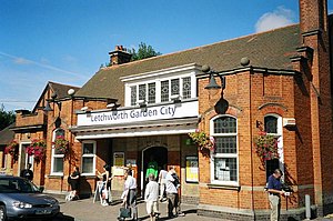
Letchworth Garden City railway station
Railway station in Hertfordshire, England
Distance: Approx. 1145 meters
Latitude and longitude: 51.980721,-0.227677
Letchworth Garden City station serves the town of Letchworth in Hertfordshire, England. The station is on the Cambridge Line 34 miles 50 chains (55.7 km) north of London King's Cross, and is a stop for services between King's Cross and Cambridge. Trains which serve the station are operated by Great Northern.
Wilbury Hill Camp
Distance: Approx. 837 meters
Latitude and longitude: 51.9775,-0.25111111
Wilbury Hill Camp is a late Bronze Age (about 700 BC) hill fort west of Letchworth in Hertfordshire. It and Arbury Banks near Ashwell are two of a line of six similar hill forts along the northern Chilterns. It is a scheduled ancient monument.

Fearnhill School
Foundation school in Letchworth, Hertfordshire, England
Distance: Approx. 837 meters
Latitude and longitude: 51.97634,-0.24746
Fearnhill School is a mixed secondary school and sixth form located in Letchworth, Hertfordshire, England.

Norton Common
Distance: Approx. 1188 meters
Latitude and longitude: 51.98527778,-0.22666667
Norton Common is a 25.7-hectare park and Local Nature Reserve in the centre of Letchworth Garden City, Hertfordshire. It is owned and managed by North Hertfordshire District Council, and the declaring authority is Hertfordshire County Council. The common has diverse wildlife including wildflowers in meadows, and black squirrel, muntjac deer, and birds such as chiffchaff and blackcap in woodland.

Pix Brook
Stream in Hertfordshire and Bedfordshire, England
Distance: Approx. 1160 meters
Latitude and longitude: 51.985,-0.227
Pix Brook is a stream in England that flows through Letchworth Garden City in Hertfordshire and Stotfold in Bedfordshire, and meets the River Hiz north of Arlesey. Colloquially known as 'Dudleys Ditch' the river is the reason why local school Etonbury Academy got the prefix 'eton' (meaning stream). It is common for younger local members of the public to go swimming in the Pix and not prohibited in any areas.

St Francis' College, Letchworth
Independent day and boarding school in Letchworth Garden City, Hertfordshire, England
Distance: Approx. 1490 meters
Latitude and longitude: 51.971888,-0.232955
St. Francis' College is an independent day and boarding school for children aged 3–18 in Letchworth, Hertfordshire. The site is within the Letchworth Conservation Area, management of which is the responsibility of the Letchworth Garden City Heritage Foundation (formerly the Letchworth Corporation).

Letchworth
Town in Hertfordshire, England
Distance: Approx. 1124 meters
Latitude and longitude: 51.978,-0.23
Letchworth Garden City, commonly known as Letchworth, is a town in the North Hertfordshire district of Hertfordshire, England. It is noted for being the first garden city. The population at the time of the 2021 census was 33,990.

Letchworth Museum & Art Gallery
Former museum in Letchworth, England
Distance: Approx. 1231 meters
Latitude and longitude: 51.9767,-0.2296
Letchworth Museum and Art Gallery was a museum in Letchworth, Hertfordshire, England. It had permanent displays dedicated to the natural history of North Hertfordshire, including the famous black squirrel, as well as its archaeology from remote prehistory to the turn of the twentieth century.

Letchworth Cemetery
Cemetery in Hertfordshire, England
Distance: Approx. 658 meters
Latitude and longitude: 51.97916667,-0.25027778
Letchworth Cemetery (properly the Icknield Way Cemetery) was the first burial ground for Letchworth Garden City in Hertfordshire. Letchworth's first cemetery and bordered by Icknield Way and Wilbury Hills Road, the cemetery is now closed for new burials but can be used if graves are being reopened and for prepurchased plots. Cremated remains are also still being interred at the cemetery.

Church of St Hugh of Lincoln, Letchworth
Church in Hertfordshire, England
Distance: Approx. 1284 meters
Latitude and longitude: 51.97630556,-0.22911111
The Church of St Hugh of Lincoln is a Catholic church in Letchworth, Hertfordshire founded by the scholar and priest Adrian Fortescue. The first church was consecrated in 1908 and was dedicated to St Hugh of Lincoln while the modern church which replaced it was built in 1963. It comes under the Diocese of Westminster.
Letchworth Town Hall
Municipal building in Letchworth, Hertfordshire, England
Distance: Approx. 1191 meters
Latitude and longitude: 51.9773,-0.2296
Letchworth Town Hall is a municipal building in Broadway, Letchworth, Hertfordshire, England. The town hall, which was the headquarters of Letchworth Urban District Council, is a Grade II listed building.

Broadway, Letchworth
Road and green space in Letchworth, Hertfordshire, England
Distance: Approx. 1353 meters
Latitude and longitude: 51.97388889,-0.23166667
Broadway is a road through the centre of Letchworth, in Hertfordshire, England, laid out when the garden city of Letchworth was created. It incorporates Broadway Gardens, and is listed Grade II in Historic England's Register of Parks and Gardens.
Weather in this IP's area
moderate rain
13 Celsius
13 Celsius
13 Celsius
14 Celsius
994 hPa
93 %
994 hPa
985 hPa
8000 meters
3.6 m/s
130 degree
100 %
07:12:16
18:24:52