193.56.175.4 - IP Lookup: Free IP Address Lookup, Postal Code Lookup, IP Location Lookup, IP ASN, Public IP
Country:
Region:
City:
Location:
Time Zone:
Postal Code:
IP information under different IP Channel
ip-api
Country
Region
City
ASN
Time Zone
ISP
Blacklist
Proxy
Latitude
Longitude
Postal
Route
Luminati
Country
ASN
Time Zone
Europe/Berlin
ISP
Plusnet GmbH
Latitude
Longitude
Postal
IPinfo
Country
Region
City
ASN
Time Zone
ISP
Blacklist
Proxy
Latitude
Longitude
Postal
Route
IP2Location
193.56.175.4Country
Region
bayern
City
wolfratshausen
Time Zone
Europe/Berlin
ISP
Language
User-Agent
Latitude
Longitude
Postal
db-ip
Country
Region
City
ASN
Time Zone
ISP
Blacklist
Proxy
Latitude
Longitude
Postal
Route
ipdata
Country
Region
City
ASN
Time Zone
ISP
Blacklist
Proxy
Latitude
Longitude
Postal
Route
Popular places and events near this IP address

Geretsried
Town in Bavaria, Germany
Distance: Approx. 6145 meters
Latitude and longitude: 47.86666667,11.46666667
Geretsried (German pronunciation: [ɡeːʁət͡sˈʁiːt] ; Bavarian: Geretsriad) is a town in the district Bad Tölz-Wolfratshausen, located in Bavaria, Germany. The town is the most populated town in the district, with 23,219 inhabitants as of 31 December 2012. The town is the site of a geothermal energy project using a novel closed-loop system that offers more environmental protection than conventional geothermal technologies.

Wolfratshausen
Place in Bavaria, Germany
Distance: Approx. 456 meters
Latitude and longitude: 47.91333333,11.42777778
Wolfratshausen (German: [vɔlfʁaːtsˈhaʊzn̩]) is a town of the district of Bad Tölz-Wolfratshausen, located in Bavaria, Germany. The town had a population of 19,033 as of 31 December 2019.

Loisach
River in Germany
Distance: Approx. 2768 meters
Latitude and longitude: 47.93638889,11.43388889
The Loisach is a river that flows through Tyrol, Austria and Bavaria, Germany. The Loisach runs through the great moors Murnauer Moos and Loisach-Kochelsee-Moore The Loisach is a 113-kilometre-long (70 mi) left tributary to the Isar whose source is near Ehrwald in Austria. It flows past Garmisch-Partenkirchen and into the Kochelsee.

Eurasburg
Municipality in Bavaria, Germany
Distance: Approx. 5396 meters
Latitude and longitude: 47.86666667,11.4
Eurasburg is a municipality in Oberbayern (Upper Bavaria). It is situated about 40 kilometres (25 miles) south of the Bavarian state capital, Munich, in the county of Bad Tölz-Wolfratshausen. Since the redistricting reforms of 1978, the municipality of Eurasburg has had an area of 40.9 square kilometres (15.8 sq mi), which includes 52 communities.

Föhrenwald
Displaced persons camps in post-World War II Germany closed in 1957
Distance: Approx. 2224 meters
Latitude and longitude: 47.900348,11.444879
Föhrenwald (German: [ˈføːʁənˌvalt]) was one of the largest displaced persons camps in post-World War II Europe and the last to close, in 1957. It was located in the section now known as Waldram in Wolfratshausen in Bavaria, Germany. The camp facilities were originally built in 1939 by IG Farben as housing for its employees at the several munitions factories that it operated in the vicinity.

Egling
Municipality in Bavaria, Germany
Distance: Approx. 7098 meters
Latitude and longitude: 47.91666667,11.51666667
Egling is a municipality in the district of Bad Tölz-Wolfratshausen in Bavaria.

Icking
Municipality in Bavaria, Germany
Distance: Approx. 4220 meters
Latitude and longitude: 47.95,11.43333333
Icking is a municipality in the district of Bad Tölz-Wolfratshausen in Bavaria in Germany.

Münsing
Municipality in Bavaria, Germany
Distance: Approx. 4351 meters
Latitude and longitude: 47.9,11.36666667
Münsing is a municipality in the district of Bad Tölz-Wolfratshausen in Bavaria in Germany. Located in the Upper Bavarian district of Bad Tölz-Wolfratshausen, it borders Lake Starnberg to its west. Its municipal area extends from the shores of Lake Starnberg to the Münsinger Rücken, a ridge which rises between the lake and the Isar valley, and also includes the western Tischberg, which forms its southern crest.
Wolfratshausen station
Railway station in Germany
Distance: Approx. 416 meters
Latitude and longitude: 47.91416,11.426956
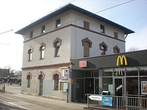
Wolfratshausen station is a station of the Munich S-Bahn. It is located in the Upper Bavarian town of Wolfratshausen in Germany. It is classified by Deutsche Bahn as a category 6 station.

Ebenhausen-Schäftlarn station
Railway station in Germany
Distance: Approx. 7748 meters
Latitude and longitude: 47.978912,11.45462
Ebenhausen-Schäftlarn station is a station on the Isar Valley Railway from Munich to Bichl in the German state of Bavaria. Since 1981, it has been a station of the Munich S-Bahn. The station building is registered as a historic building on the List of Bavarian Monuments.
Icking station
Railway station in Bavaria
Distance: Approx. 4621 meters
Latitude and longitude: 47.95319444,11.43661111
Icking station (German: Bahnhof Icking) is a railway station in the municipality of Icking, in Bavaria, Germany. It is located on the Isar Valley line of Deutsche Bahn.

Erinnerungsort Badehaus – Badehaus museum
Erinnerungsort Badehaus – Place of Remembrance of Camp for displaced persons
Distance: Approx. 2262 meters
Latitude and longitude: 47.89936111,11.44430556
The Erinnerungsort Badehaus (own spelling "BADEHAUS") is a historical museum situated at Kolpingplatz in Waldram, a district of the town of Wolfratshausen, approx. 30 km south of Munich (Germany). Documents of the settlement's history since its foundation in 1939 are exhibited in the museum.
Weather in this IP's area
few clouds
-4 Celsius
-6 Celsius
-5 Celsius
-3 Celsius
1038 hPa
97 %
1038 hPa
966 hPa
10000 meters
1.36 m/s
2.6 m/s
118 degree
20 %

