193.50.206.93 - IP Lookup: Free IP Address Lookup, Postal Code Lookup, IP Location Lookup, IP ASN, Public IP
Country:
Region:
City:
Location:
Time Zone:
Postal Code:
ISP:
ASN:
language:
User-Agent:
Proxy IP:
Blacklist:
IP information under different IP Channel
ip-api
Country
Region
City
ASN
Time Zone
ISP
Blacklist
Proxy
Latitude
Longitude
Postal
Route
db-ip
Country
Region
City
ASN
Time Zone
ISP
Blacklist
Proxy
Latitude
Longitude
Postal
Route
IPinfo
Country
Region
City
ASN
Time Zone
ISP
Blacklist
Proxy
Latitude
Longitude
Postal
Route
IP2Location
193.50.206.93Country
Region
auvergne-rhone-alpes
City
port
Time Zone
Europe/Paris
ISP
Language
User-Agent
Latitude
Longitude
Postal
ipdata
Country
Region
City
ASN
Time Zone
ISP
Blacklist
Proxy
Latitude
Longitude
Postal
Route
Popular places and events near this IP address

Nantua
Subprefecture and commune in Auvergne-Rhône-Alpes, France
Distance: Approx. 3339 meters
Latitude and longitude: 46.1519,5.6078
Nantua (French pronunciation: [nɑ̃tɥa] ; Arpitan: Nantuat) is a commune in and subprefecture of the Ain département in the Auvergne-Rhône-Alpes region in Eastern France. The commune of Nantua comprises the glacial Lac de Nantua. Located in the Haut-Bugey historical region, among the southern foothills of the Jura Mountains, it is famous for its fresh-water fish and crayfish.

Brion, Ain
Commune in Auvergne-Rhône-Alpes, France
Distance: Approx. 1549 meters
Latitude and longitude: 46.1728,5.5525
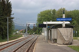
Brion (French pronunciation: [bʁijɔ̃] ) is a commune in the Ain department in eastern France. The name comes from the Latin word Bria meaning fortress, and it is home to a ruined castle. Brion—Montréal-la-Cluse station has rail connections to Bourg-en-Bresse and Oyonnax.

Montréal-la-Cluse
Commune in Auvergne-Rhône-Alpes, France
Distance: Approx. 2130 meters
Latitude and longitude: 46.1833,5.5667
Montréal-la-Cluse (French pronunciation: [mɔ̃ʁe.al la klyz] ) is a commune in the Ain department in eastern France. It is located in the historical region of Bugey and its inhabitants are known as the Montréalais.

Arrondissement of Nantua
Arrondissement in France
Distance: Approx. 3165 meters
Latitude and longitude: 46.13972222,5.58916667
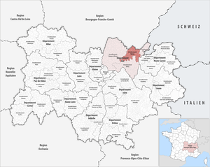
The arrondissement of Nantua is an arrondissement of France in the Ain department in the Auvergne-Rhône-Alpes region. It has 62 communes. Its population is 93,853 (2021), and its area is 899.6 km2 (347.3 sq mi).

Béard-Géovreissiat
Commune in Auvergne-Rhône-Alpes, France
Distance: Approx. 3054 meters
Latitude and longitude: 46.1906,5.5575
Béard-Géovreissiat (French pronunciation: [be.aʁ ʒe.ɔvʁɛsja]) is a commune in the Ain department in eastern France. Prior to 6 October 2008, it was known as Géovreissiat.

Port, Ain
Commune in Auvergne-Rhône-Alpes, France
Distance: Approx. 248 meters
Latitude and longitude: 46.1653,5.5711
Port (French pronunciation: [pɔʁ] ) is a commune in the Ain department in eastern France.

Saint-Martin-du-Frêne
Commune in Auvergne-Rhône-Alpes, France
Distance: Approx. 2999 meters
Latitude and longitude: 46.1394,5.5531
Saint-Martin-du-Frêne (French pronunciation: [sɛ̃ maʁtɛ̃ dy fʁɛn] ) is a commune in the Ain department in eastern France.

Canton of Nantua
Canton in Auvergne-Rhône-Alpes, France
Distance: Approx. 3336 meters
Latitude and longitude: 46.15194444,5.60777778
The canton of Nantua is an administrative division in eastern France.

Lac de Nantua
Lake in France
Distance: Approx. 1557 meters
Latitude and longitude: 46.16211667,5.58826389
The Lac de Nantua (Lake of Nantua) is a glacial lake in the southern foothills of the Jura Mountains in the Haut-Bugey historical region, located between Nantua, Montréal-la-Cluse and Port in the department of Ain, France. It covers 141 hectares (0.54 sq mi). The lake was made a protected natural site in 1935.

Ange (river)
River in eastern France
Distance: Approx. 1717 meters
Latitude and longitude: 46.1714,5.5486
The Ange(French pronunciation: [ɑ̃ʒ] ), less often called the Lange ([lɑ̃ʒ] ), is a river in the Ain department, eastern France. It is a 20.7-kilometre (12.9 mi) left tributary of the Oignin. It flows into the Rhône by the river Ain.
Brion—Montréal-la-Cluse station
Railway station in France
Distance: Approx. 1496 meters
Latitude and longitude: 46.1758,5.5585
Brion—Montréal-la-Cluse station (French: Gare de Brion—Montréal-la-Cluse) is a French railway station located in commune of Brion, Ain department in the Auvergne-Rhône-Alpes region. The station is also within close proximity of the commune of Montréal-la-Cluse, for which it is jointly named after. It is located at kilometric point (KP) 35.618 on the Ligne du Haut-Bugey (Bourg-en-Bresse–Bellegarde railway).
Nurieux station
Railway station in Nurieux-Volognat, France
Distance: Approx. 3534 meters
Latitude and longitude: 46.18421,5.53271
Nurieux station (French: Gare de Nurieux) is a French railway station located in the commune of Nurieux-Volognat, Ain department in the Auvergne-Rhône-Alpes region. Established at an elevation of 484 meters, the station is located at kilometric point (KP) 33.468 on the Ligne du Haut-Bugey, between the stations of Cize—Bolozon and Brion—Montréal-la-Cluse.
Weather in this IP's area
overcast clouds
3 Celsius
2 Celsius
3 Celsius
3 Celsius
1020 hPa
77 %
1020 hPa
937 hPa
10000 meters
1.47 m/s
1.17 m/s
109 degree
100 %

