Country:
 Poland
Region:
City:
Latitude and Longitude:
Time Zone:
Postal Code:
IP information under different IP Channel
ip-api
Country
Region
City
ASN
Time Zone
ISP
Blacklist
Proxy
Latitude
Longitude
Postal
Route
IPinfo
Country
Region
City
ASN
Time Zone
ISP
Blacklist
Proxy
Latitude
Longitude
Postal
Route
MaxMind
Country
Region
City
ASN
Time Zone
ISP
Blacklist
Proxy
Latitude
Longitude
Postal
Route
Luminati
Country
PLASN
Time Zone
Europe/Warsaw
ISP
Liberty Global B.V.
Latitude
Longitude
Postal
db-ip
Country
Region
City
ASN
Time Zone
ISP
Blacklist
Proxy
Latitude
Longitude
Postal
Route
ipdata
Country
Region
City
ASN
Time Zone
ISP
Blacklist
Proxy
Latitude
Longitude
Postal
Route
Popular places and events near this IP address

Iron Gate Square
Square in Warsaw
Distance: Approx. 454 meters
Latitude and longitude: 52.23944444,21.00194444
Iron Gate Square Square (Plac Żelaznej Bramy) is a large open space in the city center of Warsaw. The square took its name from a large iron gate that once secured the western boundary of the Saxon Garden.
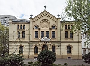
Nożyk Synagogue
Orthodox synagogue in Warsaw, Poland
Distance: Approx. 442 meters
Latitude and longitude: 52.23611111,21.00111111
The Nożyk Synagogue (Polish: Synagoga Nożyków) is an Orthodox Jewish congregation and synagogue, located at 6 Twarda Street, in the Śródmieście district of Warsaw, in the Masovian Voivodeship of Poland. Designed by Karol Kozłowski in the Romanesque Revival and Rundbogenstil styles and completed in 1902, the synagogue is the only surviving prewar Jewish house of prayer in Warsaw. The synagogue was desecrated by Nazis during World War II, was restored after the war, and remains operational.
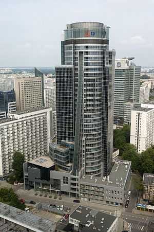
Spektrum Tower
Distance: Approx. 486 meters
Latitude and longitude: 52.2344,20.9991
The Spektrum Tower (formerly TP S.A. Tower) is a highrise office tower in Warsaw, the capital of Poland. It is located at 14/16 Twarda Street in the Warszawa-Śródmieście central business district of the city and used to house the headquarters of its investor, the telecom operator Telekomunikacja Polska S.A. (TP S.A.), with some space being leased to other companies. The building of the tower was initially contracted to PIA Piasecki S.A. on 1 August 1997, originally due to be completed 30 June 2002.

Mier Halls
Distance: Approx. 201 meters
Latitude and longitude: 52.23888889,20.99833333
Mier Halls (Polish: Hale Mirowskie) are two twin market halls located in the Mirów neighbourhood, in central Warsaw, Poland. Constructed between 1899 and 1902, it was Warsaw's first major food hall complex and also the city's largest market. The buildings were partially destroyed during the 1944 Warsaw Uprising and restored to its original function as a market in the 1950s and 1960s.

Jewish Theatre, Warsaw
Distance: Approx. 523 meters
Latitude and longitude: 52.23583333,21.00222222
The Ester Rachel and Ida Kaminska Jewish Theater (Polish: Teatr Żydowski im. Estery Racheli i Idy Kamińskich) is a state theatrical institution in Warsaw, Poland. It was named after the Polish-Jewish actress Ester Rachel Kamińska, who was called the "mother of Yiddish theater," and her daughter, the Academy Award-nominated actress Ida Kamińska.

Cosmopolitan Twarda 2/4
Residential skyscraper
Distance: Approx. 478 meters
Latitude and longitude: 52.235,21.00027778
Cosmopolitan Twarda 2/4, formerly known as Twarda Tower or Hines Tower, is a mainly residential skyscraper (160 meters high, 44 storeys) in central Warsaw, Poland. The project was developed by Tacit Development Polska. The tower includes 252 apartments ranging from 54 to 198 square metres (580 to 2,130 sq ft), with a net total area of above-ground floors of as much as 32,000 m2 (340,000 sq ft).
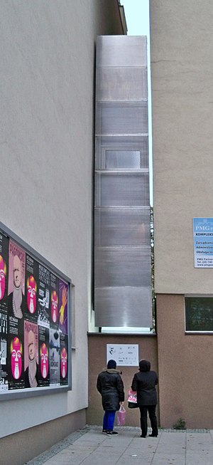
Keret House
Building in Warsaw, Poland
Distance: Approx. 448 meters
Latitude and longitude: 52.237703,20.989075
Keret House is a structure and art installation in Warsaw, Poland. It was designed by the architect Jakub Szczęsny through the architecture firm Centrala, and has been described as the narrowest house in the world, measuring 92 centimetres (3.02 ft) at its thinnest point and 152 centimetres (4.99 ft) at its widest. The two-story art installation was named after Israeli writer and filmmaker Etgar Keret, who was the building's first tenant.
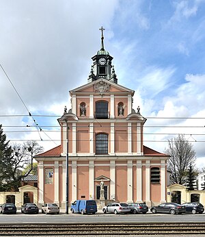
Church of the Nativity of the Blessed Virgin Mary, Warsaw
Church in Warsaw, Poland
Distance: Approx. 511 meters
Latitude and longitude: 52.242778,20.995
The Church of the Nativity of the Blessed Virgin Mary is a Roman Catholic church located at 80 Solidarności Avenue (formerly 32 Leszno Street) in Warsaw.

Tadeusz Kościuszko Monument, Warsaw
Monument in Warsaw, Poland
Distance: Approx. 495 meters
Latitude and longitude: 52.23961,21.00248
The Tadeusz Kościuszko Monument in Warsaw (Polish: Pomnik Tadeusza Kościuszki w Warszawie) is a statue dedicated to commemorate the national hero of Poland, Lithuania, Belarus, and the United States, general Tadeusz Kościuszko (1746–1817), and situated on the Iron-Gate Square in front of the Lubomirski Palace.

Skysawa
Skyscraper in Warsaw, Poland
Distance: Approx. 547 meters
Latitude and longitude: 52.23388889,20.99944444
Skysawa is a pair of buildings in the center of Warsaw, Poland. The buildings are at 36 Świętokrzyska Street on a lot previously occupied by a 1960s 10-storey office building. Its overall approximate floor area will be 40,000 sqm.

Żelazna Brama (neighbourhood)
Municipal neighbourhood in Warsaw, Masovian Voivodeship, Poland
Distance: Approx. 437 meters
Latitude and longitude: 52.23694444,21.00166667
Żelazna Brama, also designated as the Neighbourhood No. 3, is a municipal neighbourhood of the city of Warsaw, Poland, located within the district of Śródmieście, and administered by a neighbourhood council. It is located within the City Information System area of Śródmieście Północne.

Mier Park
An urban park in Warsaw, Poland
Distance: Approx. 311 meters
Latitude and longitude: 52.23846,21.000135
The Mier Park (Polish: Park Mirowski), also known as the Downtown Park (Polish: Park Śródmiejski), is an urban park in Warsaw, Poland. The park is located in the district of Downtown, between Jana Pawła II Avenue, Marszałkowska Street, Mier Halls, and the Za Żelazną Bramą neighbourhood.
Weather in this IP's area
clear sky
20 Celsius
19 Celsius
18 Celsius
21 Celsius
1018 hPa
52 %
1018 hPa
1005 hPa
10000 meters
9.39 m/s
150 degree
05:59:28
19:08:08