Country:
 Switzerland
Region:
City:
Latitude and Longitude:
Time Zone:
Postal Code:
IP information under different IP Channel
ip-api
Country
Region
City
ASN
Time Zone
ISP
Blacklist
Proxy
Latitude
Longitude
Postal
Route
IPinfo
Country
Region
City
ASN
Time Zone
ISP
Blacklist
Proxy
Latitude
Longitude
Postal
Route
MaxMind
Country
Region
City
ASN
Time Zone
ISP
Blacklist
Proxy
Latitude
Longitude
Postal
Route
Luminati
Country
CHASN
Time Zone
Europe/Zurich
ISP
NTS workspace AG
Latitude
Longitude
Postal
db-ip
Country
Region
City
ASN
Time Zone
ISP
Blacklist
Proxy
Latitude
Longitude
Postal
Route
ipdata
Country
Region
City
ASN
Time Zone
ISP
Blacklist
Proxy
Latitude
Longitude
Postal
Route
Popular places and events near this IP address

A1 motorway (Switzerland)
Motorway in Switzerland
Distance: Approx. 2280 meters
Latitude and longitude: 47.031437,7.527266
The A1 is a motorway in Switzerland. It follows Switzerland's main east–west axis, from St. Margrethen in northeastern Switzerland's canton of St.

Mattstetten
Municipality in Bern, Switzerland
Distance: Approx. 1844 meters
Latitude and longitude: 47.03333333,7.51666667
Mattstetten is a municipality in the Bern-Mittelland administrative district in the canton of Bern in Switzerland.

Moosseedorf
Municipality in Bern, Switzerland
Distance: Approx. 1494 meters
Latitude and longitude: 47.01666667,7.48333333
Moosseedorf is a municipality in the Bern-Mittelland administrative district in the canton of Bern in Switzerland. The village is located south of Moossee, the lake that gives it its name.

Urtenen-Schönbühl
Municipality in Bern, Switzerland
Distance: Approx. 1507 meters
Latitude and longitude: 47.03333333,7.5
Urtenen-Schönbühl is a municipality in the Bern-Mittelland administrative district in the canton of Bern in Switzerland.
Bäriswil, Bern
Municipality in Bern, Switzerland
Distance: Approx. 2372 meters
Latitude and longitude: 47.01666667,7.53333333
Bäriswil is a municipality in the district of Bern-Mittelland in the canton of Bern in Switzerland.

Moossee
Lake in the canton of Bern, Switzerland
Distance: Approx. 1697 meters
Latitude and longitude: 47.02194444,7.48027778
Moossee (or Grosser Moossee) is a lake in the canton of Bern, Switzerland. Its surface area is 31 ha (77 acres). The lake gives the name to Moosseedorf (literally "village of Moossee") on its southern shore.
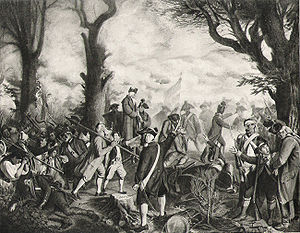
Battle of Grauholz
Battle between the First French Republic and the Canton of Bern
Distance: Approx. 405 meters
Latitude and longitude: 47.01666667,7.5
The Battle of Grauholz on 5 March 1798 was a battle between a Bernese army under Karl Ludwig von Erlach against the French Revolutionary Army under Balthazar Alexis Henri Schauenburg. The battle took place at Grauholz, a wooded hill in what is now the municipalities of Urtenen-Schönbühl and Moosseedorf in the canton of Bern in Switzerland. The government of Bern had already surrendered the previous day, and the Bernese defeat at Grauholz ended their resistance to the French in the north of the canton.

Schönbühl SBB railway station
Railway station in Urtenen-Schönbühl, Switzerland
Distance: Approx. 288 meters
Latitude and longitude: 47.01893,7.49892889
Schönbühl SBB railway station (German: Bahnhof Schönbühl SBB) is a railway station in the municipality of Urtenen-Schönbühl, in the Swiss canton of Bern. It is an intermediate stop on the standard gauge Olten–Bern line of Swiss Federal Railways. The station is approximately 290 metres (950 ft) south of Schönbühl RBS on the 1,000 mm (3 ft 3+3⁄8 in) gauge Solothurn–Worblaufen line of Regionalverkehr Bern-Solothurn.
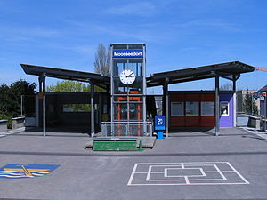
Moosseedorf railway station
Railway station in Moosseedorf, Switzerland
Distance: Approx. 1389 meters
Latitude and longitude: 47.01611111,7.485
Moosseedorf railway station (German: Bahnhof Moosseedorf) is a railway station in the municipality of Moosseedorf, in the Swiss canton of Bern. It is an intermediate stop on the 1,000 mm (3 ft 3+3⁄8 in) gauge Solothurn–Worblaufen line of Regionalverkehr Bern-Solothurn.

Schönbühl Shoppyland railway station
Railway station in Urtenen-Schönbühl, Switzerland
Distance: Approx. 659 meters
Latitude and longitude: 47.01888889,7.49388889
Schönbühl Shoppyland railway station (German: Bahnhof Schönbühl Shoppyland) is a railway station in the municipality of Moosseedorf, in the Swiss canton of Bern. It is an intermediate stop on the 1,000 mm (3 ft 3+3⁄8 in) gauge Solothurn–Worblaufen line of Regionalverkehr Bern-Solothurn. The station serves the Shoppyland Schönbühl shopping center.
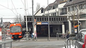
Schönbühl RBS railway station
Railway station in Urtenen-Schönbühl, Switzerland
Distance: Approx. 659 meters
Latitude and longitude: 47.01888889,7.49388889
Schönbühl RBS railway station (German: Bahnhof Schönbühl RBS) is a railway station in the municipality of Urtenen-Schönbühl, in the Swiss canton of Bern. It is an intermediate stop on the 1,000 mm (3 ft 3+3⁄8 in) gauge Solothurn–Worblaufen line of Regionalverkehr Bern-Solothurn. The station is approximately 290 metres (950 ft) north of Schönbühl SBB on the standard gauge Olten–Bern line of Swiss Federal Railways.

Urtenen railway station
Railway station in Urtenen-Schönbühl, Switzerland
Distance: Approx. 1006 meters
Latitude and longitude: 47.02888889,7.50111111
Urtenen railway station (German: Bahnhof Urtenen) is a railway station in the municipality of Urtenen-Schönbühl, in the Swiss canton of Bern. It is an intermediate stop on the 1,000 mm (3 ft 3+3⁄8 in) gauge Solothurn–Worblaufen line of Regionalverkehr Bern-Solothurn.
Weather in this IP's area
overcast clouds
17 Celsius
18 Celsius
16 Celsius
19 Celsius
1014 hPa
91 %
1014 hPa
953 hPa
10000 meters
1.03 m/s
100 %
06:58:57
19:56:35