Country:
Region:
City:
Latitude and Longitude:
Time Zone:
Postal Code:
IP information under different IP Channel
ip-api
Country
Region
City
ASN
Time Zone
ISP
Blacklist
Proxy
Latitude
Longitude
Postal
Route
Luminati
Country
ASN
Time Zone
Europe/Kyiv
ISP
Merezha LLC
Latitude
Longitude
Postal
IPinfo
Country
Region
City
ASN
Time Zone
ISP
Blacklist
Proxy
Latitude
Longitude
Postal
Route
db-ip
Country
Region
City
ASN
Time Zone
ISP
Blacklist
Proxy
Latitude
Longitude
Postal
Route
ipdata
Country
Region
City
ASN
Time Zone
ISP
Blacklist
Proxy
Latitude
Longitude
Postal
Route
Popular places and events near this IP address

Darnytskyi District
Urban district in Kyiv in Kyiv City Municipality, Ukraine
Distance: Approx. 3316 meters
Latitude and longitude: 50.40611111,30.67666667
Darnytskyi District (Ukrainian: Дарницький район, romanized: Darnytskyi raion) is an urban district of the Ukrainian capital Kyiv. It is the southeastern district of Kyiv, located on the left bank of the Dnipro river. It borders the Holosiivskyi District of the city to its west, across the river, Dniprovskyi District of city to its north, and the Brovary Raion of the Kyiv Oblast to its east and Boryspil Raion of Kyiv Oblast to its east and south.

Vyrlytsia (Kyiv Metro)
Kyiv Metro Station
Distance: Approx. 2543 meters
Latitude and longitude: 50.40333333,30.66611111
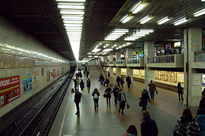
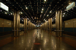
Vyrlytsia (Ukrainian: Вирлиця, ) is a station on the Kyiv Metro's Syretsko-Pecherska Line. It was opened on 4 March 2006 on the already functioning stretch, Kharkivska-Boryspilska. The station is by far the most unusual in the system.

Darnytsia railway station
Railway station in Kyiv, Ukraine
Distance: Approx. 3387 meters
Latitude and longitude: 50.43111111,30.64611111
Darnytsia (Ukrainian: Дарниця) is the largest Ukrainian Railways station (and the main freight station) of the Ukrainian capital Kyiv, located in the city's Left-bank Darnytsia neighborhood. Built in the nineteenth century, the Darnytsia railway hub has grown into a gigantic railway center, expanding for more than 10 km along the main east–west route. Started in 2004, construction is under way at the new Darnytsia railway terminal complex.

Pozniaky
Distance: Approx. 708 meters
Latitude and longitude: 50.4087,30.6289
Pozniaky (Ukrainian: Позняки) is a historical neighbourhood, a residential area and the remains of a village on the territory of the Darnitskyi district, on the left bank of Kyiv, the capital of Ukraine. Pozniaky metro station is situated in this neighborhood. Pozniaky is a historical area, of Kyiv.
Osokorky
Neighbourhood in Kyiv, Ukraine
Distance: Approx. 1361 meters
Latitude and longitude: 50.39460556,30.61551667
Osokorky (Ukrainian: Осокорки) is a historical neighbourhood, on the left bank of Kyiv, the capital of Ukraine. Osokorky metro station is situated in this neighborhood.
Embassy of the Blessed Kingdom of God for All Nations
Church in Kyiv, Ukraine
Distance: Approx. 2073 meters
Latitude and longitude: 50.39756,30.60209
Embassy of the Blessed Kingdom of God for All Nations (also known as Embassy of God) is an Evangelical Christian Charismatic megachurch, denomination, and parachurch organization headquartered in Kyiv, Ukraine. The senior pastor is Sunday Adelaja.

Kharkivska (Kyiv Metro)
Kyiv Metro Station
Distance: Approx. 1565 meters
Latitude and longitude: 50.40083333,30.65222222
Kharkivska (Ukrainian: Харківська, ) is a station of Kyiv Metro's Syretsko-Pecherska Line. It is between the Pozniaky and Vyrlytsia stations. This station was opened on 28 December 1994.

Pozniaky (Kyiv Metro)
Kyiv Metro Station
Distance: Approx. 529 meters
Latitude and longitude: 50.39805556,30.63333333
Pozniaky (Ukrainian: Позняки, ) is a station of Kyiv Metro's Syretsko–Pecherska line. It is situated between Osokorky and Kharkivska stations. This station was opened on 28 December 1994.
Osokorky (Kyiv Metro)
Kyiv Metro Station
Distance: Approx. 1278 meters
Latitude and longitude: 50.39555556,30.61583333
Osokorky (Ukrainian: Осокорки, ) is a station of Kyiv Metro's Syretsko-Pecherska Line. It is situated between Slavutych and Pozniaky stations. This station was opened on 30 December 1992.

Slavutych (Kyiv Metro)
Kyiv Metro Station
Distance: Approx. 2069 meters
Latitude and longitude: 50.39416667,30.60416667
Slavutych (Ukrainian: Славутич, ) is a station on Kyiv Metro's Syretsko–Pecherska line. It is situated between Vydubychi and Osokorky stations and was opened on 30 December 1992. The station was designed by architect Alyoshkin.
Chervonyi Khutir
Historic neighbourhood in Kyiv, Ukraine
Distance: Approx. 3367 meters
Latitude and longitude: 50.40846667,30.67679167
Chervonyi Khutir (Ukrainian: Червоний Хутір) is a historic neighbourhood in the Darnytskyi District of Kyiv, the capital of Ukraine. It is located between Kharkivske Highway, Kronshtadtska Street, Borova Street, Yalynkova Street, and forest. Most of the buildings are low-rise private homes, while some are industrial enterprises.

Pivdennyi Bridge (Kyiv)
Bridge in Kyiv, Ukraine
Distance: Approx. 3109 meters
Latitude and longitude: 50.39481,30.58814
The Pivdennyi Bridge (Ukrainian: Південний міст - Southern bridge) in Kyiv, Ukraine was designed by the architect A. Gavrilov ("Mostobud") and a group of engineers headed by G. Fux, was built in 1990.
Weather in this IP's area
overcast clouds
2 Celsius
2 Celsius
1 Celsius
3 Celsius
1016 hPa
97 %
1016 hPa
1004 hPa
10000 meters
0.45 m/s
1.79 m/s
242 degree
96 %
07:12:06
16:12:22
