Country:
 Switzerland
Region:
City:
Latitude and Longitude:
Time Zone:
Postal Code:
IP information under different IP Channel
ip-api
Country
Region
City
ASN
Time Zone
ISP
Blacklist
Proxy
Latitude
Longitude
Postal
Route
IPinfo
Country
Region
City
ASN
Time Zone
ISP
Blacklist
Proxy
Latitude
Longitude
Postal
Route
MaxMind
Country
Region
City
ASN
Time Zone
ISP
Blacklist
Proxy
Latitude
Longitude
Postal
Route
Luminati
Country
CHASN
Time Zone
Europe/Zurich
ISP
VTX Services SA
Latitude
Longitude
Postal
db-ip
Country
Region
City
ASN
Time Zone
ISP
Blacklist
Proxy
Latitude
Longitude
Postal
Route
ipdata
Country
Region
City
ASN
Time Zone
ISP
Blacklist
Proxy
Latitude
Longitude
Postal
Route
Popular places and events near this IP address

FIFA
International governing body of association football
Distance: Approx. 980 meters
Latitude and longitude: 47.38138889,8.57444444
The Fédération Internationale de Football Association (lit. 'International Federation of Association Football'), more commonly known by its acronym FIFA ( FEE-fə), is the international self-regulatory governing body of association football, beach soccer, and futsal. It was founded in 1904 to oversee international competition among the national associations of Belgium, Denmark, France, Germany, the Netherlands, Spain (represented by the Madrid Football Club), Sweden, and Switzerland. Headquartered in Zürich, Switzerland, its membership now comprises 211 national associations.
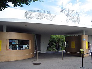
Zürich Zoologischer Garten
Zoo in Zurich
Distance: Approx. 1275 meters
Latitude and longitude: 47.385,8.57305556
The Zoo Zürich is a zoo located in Zürich, Switzerland. It is considered one of the best zoos in Europe. Opened in 1929, it is the third oldest zoo in Switzerland (after Basel and Arth-Goldau) and it accumulated a collection of 2,200 specimens of 300 species by its seventy-fifth year.

Zürichberg
Wooded hill in Switzerland
Distance: Approx. 1694 meters
Latitude and longitude: 47.38555556,8.56694444
The Zürichberg is a wooded hill rising to 679 m (2,228 feet), overlooking Lake Zürich and located immediately to the east of the city of Zürich, Switzerland, between the valleys of the Limmat and the Glatt rivers. Its highest point is about 270 metres above the Limmat and it is part of a chain of hills, such as Käferberg, Adlisberg, Forch and Pfannenstiel, between the Greifensee/Glattal and Lake Zürich. It is a picturesque location, and the lower western side of the hill is now part of the residential district of Zürich.

Fluntern Cemetery
Cemetery in Zürich, Switzerland
Distance: Approx. 1291 meters
Latitude and longitude: 47.383,8.571
Also known as Friedhof Fluntern, the Fluntern Cemetery is located in the Zürichberg district of Zürich.

Witikon
Distance: Approx. 1283 meters
Latitude and longitude: 47.36666667,8.58333333
Witikon is a quarter in the district 7 in Zürich. It was formerly a municipality of its own, having been incorporated into Zürich in 1934. The quarter has a population of 9,864 distributed on an area of 4.93 km2 (1.90 sq mi).
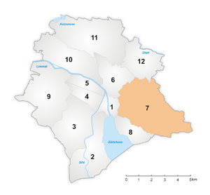
District 7 (Zürich)
District in Zürich, Switzerland
Distance: Approx. 739 meters
Latitude and longitude: 47.373,8.58
District 7 is a district east of the old town in the Swiss city of Zürich. The district comprises the quarters Fluntern, Hottingen, Hirslanden and Witikon. All entities were formerly municipalities of their own, but were incorporated into Zürich in 1893 (Witikon in 1934).

Dolder Grand
Hotel in Zürich, Switzerland
Distance: Approx. 1154 meters
Latitude and longitude: 47.3728,8.5732
The Dolder Grand (formerly known as Grand Hotel Dolder) is a 5 star superior hotel in the Swiss city of Zürich. It is located on Adlisberg hill, some 2 kilometres (1.2 mi) from, and 200 metres (660 ft) above, the city centre. Built in 1899, the hotel spreads out over 40,000 square metres (430,000 sq ft) and offers 173 rooms and suites, two restaurants, a bar, 13 conference rooms and a 4,000-square-metre (43,000 sq ft) spa.
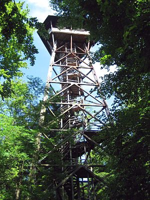
Loorenkopf
Distance: Approx. 1337 meters
Latitude and longitude: 47.36944444,8.59888889
Loorenkopf tower is a 33-metre (108 ft) high freestanding wood lattice tower on Adlisberg, north of Witikon in Zürich, Switzerland. It was built in 1954. The tower is owned by Zürich city and it is open to the public.

Adlisberg
Mountain in Zürich, Switzerland
Distance: Approx. 956 meters
Latitude and longitude: 47.37055556,8.59277778
Adlisberg, with an elevation of 701 metres (2,300 ft), is a wooded mountain in Switzerland overlooking Zürichsee (Lake Zürich) to the northwest near the Zürichberg.
Federación Internacional de Fútbol Rápido
International governing body of indoor soccer
Distance: Approx. 984 meters
Latitude and longitude: 47.3814,8.5744
The Federación Internacional de Fútbol Rápido, commonly known by the acronym FIFRA, was the international governing body of indoor soccer (Spanish: fútbol rápido). From 2008–2013 FIFRA was responsible for the organization and governance of indoor soccer's major international tournaments. In North America, the MASL umbrella of leagues were official affiliates of FIFRA, including the Professional Arena Soccer League and Premier Arena Soccer League.

Dolderbahn
Rack railway in the Swiss city of Zurich
Distance: Approx. 1620 meters
Latitude and longitude: 47.372132,8.566792
The Dolderbahn (Db or DBZ) is a 1.3 km (0.81 mi) long rack railway in the Swiss city of Zürich. The line is in Zürich's Hottingen and Fluntern suburbs on the south slope of the Adlisberg mountain. The lower terminus of the line is at Römerhof, some 1.5 km (0.93 mi) from the city centre, where it connects with lines 3 and 8 of the Zürich tramway.
World Freestyle Football Association
Governing body of freestyle football
Distance: Approx. 980 meters
Latitude and longitude: 47.38138889,8.57444444
The World Freestyle Football Association (WFFA) is the international governing body of freestyle football. Freestyle football is defined as an art and sport, which involves participants creatively juggling a ball using all parts of the body to entertain audiences and outperform opponents; it combines street culture of football tricks, dance, acrobatics and music.
Weather in this IP's area
broken clouds
15 Celsius
15 Celsius
13 Celsius
17 Celsius
1012 hPa
84 %
1012 hPa
939 hPa
10000 meters
0.89 m/s
1.34 m/s
109 degree
75 %
06:51:38
19:56:37