Country:
 Iceland
Region:
City:
Latitude and Longitude:
Time Zone:
Postal Code:
IP information under different IP Channel
ip-api
Country
Region
City
ASN
Time Zone
ISP
Blacklist
Proxy
Latitude
Longitude
Postal
Route
IPinfo
Country
Region
City
ASN
Time Zone
ISP
Blacklist
Proxy
Latitude
Longitude
Postal
Route
MaxMind
Country
Region
City
ASN
Time Zone
ISP
Blacklist
Proxy
Latitude
Longitude
Postal
Route
Luminati
Country
ISRegion
1
City
mosfellsbaer
ASN
Time Zone
Atlantic/Reykjavik
ISP
Ljosleidarinn ehf
Latitude
Longitude
Postal
db-ip
Country
Region
City
ASN
Time Zone
ISP
Blacklist
Proxy
Latitude
Longitude
Postal
Route
ipdata
Country
Region
City
ASN
Time Zone
ISP
Blacklist
Proxy
Latitude
Longitude
Postal
Route
Popular places and events near this IP address

Mosfellsbær
Municipality in Capital Region, Iceland
Distance: Approx. 1505 meters
Latitude and longitude: 64.17,-21.72
Mosfellsbær (Icelandic pronunciation: [ˈmɔːsˌfɛlsˌpaiːr̥] , colloquially Mosó) is a town in south-west Iceland, 12 kilometres (7 miles) east of the country's capital, Reykjavík. The coat of arms of the municipality is a tightly-knotted triquetra, a symbol often used in Celtic knotwork and strongly associated with the Celtic nations (which featured prominently in Celtic spirituality as well as Ancient Celtic religion in the past and, to some extent, to this day). The coat of arms might denote the Gaelic heritage of Mosfellsbær as Icelanders are also descended from Gaelic-speaking settlers who voyaged or were brought by the Norsemen in Iceland during the country's settlement in the Viking Age.

Grafarvogur
District in Reykjavík, Iceland
Distance: Approx. 5165 meters
Latitude and longitude: 64.14722222,-21.78333333
Grafarvogur (Icelandic pronunciation: [ˈkraːvarˌvɔːɣʏr̥]) is among the largest residential districts of Reykjavík, Iceland. It is a relatively new neighbourhood and is located in eastern most side of Reykjavík, major construction began in the late 1980s and continued well into the 1990s.
Sundlaugin
Distance: Approx. 558 meters
Latitude and longitude: 64.16678333,-21.67856667
Sundlaugin (Icelandic pronunciation: [ˈsʏntˌlœyjɪn], the swimming pool) is a recording studio located near Álafoss in the town of Mosfellsbær in Iceland known for being the recording and rehearsal location of post-rock band Sigur Rós. The location was originally a swimming pool built in the 1930s which had been abandoned when Sigur Rós purchased it in 1999 and converted it and adjacent buildings into a studio. The band originally intended to record their third album, titled ( ), in an abandoned NATO tracking base in the northernmost mountain in Iceland, but after inspection decided it was too impractical.
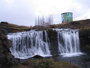
Álafoss
Waterfall in Iceland
Distance: Approx. 690 meters
Latitude and longitude: 64.1666,-21.6758
Álafoss (Icelandic pronunciation: [ˈauːlaˌfɔsː]; eel falls) is a waterfall on the river Varmá in Mosfellsbær, Iceland.
Egilshöll
Icelandic sports & entertainment facility
Distance: Approx. 4595 meters
Latitude and longitude: 64.14694444,-21.76944444
Egilshöll (Icelandic pronunciation: [ˈeijɪlsˌhœtl̥]), also known as Egilshöllin, is a multi-purpose sports and entertainment facility located in the Grafarvogur district of Iceland's capital Reykjavík. It features three football pitches, an ice rink, school sports hall, gym, shooting range, tennis courts and a cinema.

Gufunes
Distance: Approx. 6463 meters
Latitude and longitude: 64.14694444,-21.8125
Gufunes (Icelandic pronunciation: [ˈkʏːvʏˌnɛːs]) is a historical estate and park for sculptures and artwork in northeastern Reykjavík. Today it lies within the Grafarvogur part of the city, located to the southwest and south of the Eidsvik Cove and Geldinganes Headland. It contains some 25 sculptures by Hallsteinn Sigurðsson amongst others.
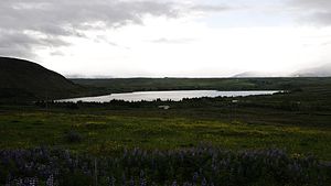
Hafravatn
Small lake on the eastern outskirts of Reykjavík, Iceland
Distance: Approx. 4449 meters
Latitude and longitude: 64.130574,-21.662336
Hafravatn (Icelandic pronunciation: [ˈhavraˌvahtn̥]) is a small lake on the eastern outskirts of Reykjavík, Iceland. Located at 76 m above sea level, it has an area of 1.08 km2 (0.42 sq mi) with a greatest depth of 28 m (92 ft). The Seljadalsá River flows into it from the east and its discharge is Úlfarsá (into Korpúlfsstaðaá, also known as Ulfarsfellsa).

Grafarholt og Úlfarsárdalur
District in Reykjavík, Iceland
Distance: Approx. 6049 meters
Latitude and longitude: 64.12645,-21.767192
Úlfarsfell (Icelandic pronunciation: [ˈulvar̥sˌfɛtl̥]) or Grafarholt og Úlfarsárdalur [ˈkraːvarˌhɔl̥t ɔɣ ˈulvar̥sˌaurˌtaːlʏr̥], is a district of Reykjavík, the capital of Iceland, and forms part of the eastern suburbs. A small lake, Reynisvatn, is situated to the east of the district.
Fjölnisvöllur
Stadium in Iceland
Distance: Approx. 5877 meters
Latitude and longitude: 64.13846,-21.7882
Fjölnisvöllur (Icelandic pronunciation: [ˈfjœlnɪsˌvœtlʏr̥]) is a football stadium in Iceland. It is located in Grafarvogur, Reykjavík, and seats 700 individuals in one stand, but can hold about 500 standing spectators additionally. It is the home stadium for Icelandic football team Fjölnir.
Reykjavik Golf Club
Icelandic golf course
Distance: Approx. 3844 meters
Latitude and longitude: 64.1523,-21.7587
The Reykjavik Golf Club is a golf club located 10 kilometres (6.2 mi) east of Reykjavik, Iceland. The club was established in 1934 and is the oldest and largest golf club in Iceland. It has hosted many European and Scandinavian tournaments including major events such as the European Youth and European Seniors Tour Championships.
Varmárvöllur
Distance: Approx. 22 meters
Latitude and longitude: 64.169,-21.6891
Varmárvöllur is a multi-use stadium in Mosfellsbær, Iceland. It is currently used mostly for football matches and is the home stadium of Ungmennafélagið Afturelding. Its capacity is around 2500.

Úlfarsfell
Mountain in Iceland
Distance: Approx. 2636 meters
Latitude and longitude: 64.147,-21.7103
Úlfarsfell (Icelandic pronunciation: [ˈulvar̥sˌfɛtl̥]) is a mountain in the municipality of Mosfellsbær in the Reykjavík metropolitan area. It is 296 meters high. The mountain slopes have been subject to extensive forestry.
Weather in this IP's area
broken clouds
7 Celsius
3 Celsius
6 Celsius
7 Celsius
1003 hPa
68 %
1003 hPa
1000 hPa
10000 meters
5.77 m/s
7.32 m/s
276 degree
82 %
06:30:42
20:18:18