Country:
 Norway
Region:
City:
Latitude and Longitude:
Time Zone:
Postal Code:
IP information under different IP Channel
ip-api
Country
Region
City
ASN
Time Zone
ISP
Blacklist
Proxy
Latitude
Longitude
Postal
Route
IPinfo
Country
Region
City
ASN
Time Zone
ISP
Blacklist
Proxy
Latitude
Longitude
Postal
Route
MaxMind
Country
Region
City
ASN
Time Zone
ISP
Blacklist
Proxy
Latitude
Longitude
Postal
Route
Luminati
Country
NOASN
Time Zone
Europe/Oslo
ISP
Globalconnect As
Latitude
Longitude
Postal
db-ip
Country
Region
City
ASN
Time Zone
ISP
Blacklist
Proxy
Latitude
Longitude
Postal
Route
ipdata
Country
Region
City
ASN
Time Zone
ISP
Blacklist
Proxy
Latitude
Longitude
Postal
Route
Popular places and events near this IP address

Kvadrat (shopping centre)
Distance: Approx. 1282 meters
Latitude and longitude: 58.87665,5.72146944
Kvadrat is one of the largest shopping centres in Norway both by revenue and number of shops. The shopping centre is situated in Sandnes, Norway. Kvadrat Storsenter was opened in 1984 and contains 160 stores in several connected buildings totalling 84 912 m2.

Gandsfjord
Fjord in Norway
Distance: Approx. 1547 meters
Latitude and longitude: 58.8902,5.763
Gandsfjorden or Gandafjorden is a fjord in Rogaland county, Norway. The 13-kilometre (8.1 mi) long Gandsfjorden is an arm off of the large Boknafjorden. It runs between the mainland and the Stavanger Peninsula in the western parts of the municipalities of Stavanger and Sandnes.

Hetland
Former municipality in Rogaland, Norway
Distance: Approx. 1194 meters
Latitude and longitude: 58.89222222,5.73361111
Hetland is a former municipality in Rogaland county, Norway. The municipality existed from 1838 until 1965 when it was dissolved. The municipality included the Stavanger Peninsula and the land surrounding both sides of the Gandsfjorden, but not the area around the head of the fjord.
Forus Upper Secondary School
Distance: Approx. 152 meters
Latitude and longitude: 58.8832,5.7392
Forus Upper Secondary School (Norwegian: Forus Videregående Skole) was an upper secondary school in Sandnes, Norway. It offered vocational studies, focused mainly on fine arts, and media and communication (photography, graphic design, video, computers etc.). It was the only upper secondary school in Norway to only offer artistic, visual and creative studies.
Radio Narvik
Distance: Approx. 1865 meters
Latitude and longitude: 58.8656,5.7454
Radio Narvik was a local radio station which covered the whole Ofoten district, including Narvik, Ankenesstrand, Ballangen and Bjerkvik. The frequency was FM 103.5 and 105.5 in all areas. It was also possible to listen via internet radio.

Equinor
Norwegian energy company
Distance: Approx. 1725 meters
Latitude and longitude: 58.8918,5.71745
Equinor ASA (formerly Statoil and StatoilHydro) is a Norwegian state-owned multinational energy company headquartered in Stavanger, Norway. It is primarily a petroleum company operating in 36 countries with additional investments in renewable energy. In the 2020 Forbes Global 2000, Equinor was ranked as the 169th-largest public company in the world.
Stokka, Sandnes
Distance: Approx. 1339 meters
Latitude and longitude: 58.88305556,5.71777778
Stokka is a neighborhood in the borough of Lura in the northwestern corner of the city of Sandnes which lies in the far western edge of the large Sandnes municipality in Rogaland county, Norway. Stokka is bordered on the south by the borough of Malmheim og Soma, to the east by the urban part of the borough of Lura, to the north by Forus in the neighboring city of Stavanger, and to the west by Sola municipality. Large parts of the area are industrialised, with the area north of the road Løwenstrasse used as the headquarters of Forus Næringspark.
British International School of Stavanger
Distance: Approx. 1748 meters
Latitude and longitude: 58.8974,5.7334
The British International School of Stavanger is an international school in Stavanger, Norway. It was founded in 1977. The school currently caters to approximately 500 pupils from over 50 different nationalities, from 18 months of age up to the age of 19.
Forus
Industrial district of Stavanger, Norway
Distance: Approx. 459 meters
Latitude and longitude: 58.88333333,5.73333333
Forus is an industrial district in the city of Stavanger which lies in the southwestern part of the large municipality of Stavanger in Rogaland county, Norway. It is located in the borough of Hinna, along the Gandsfjorden and it stretches south and west to the municipalities of Sandnes and Sola. The name Forus originates from an old farm located in this area, part of which is currently used for harness racing.

Lura, Norway
Borough in Western Norway, Norway
Distance: Approx. 1805 meters
Latitude and longitude: 58.86666667,5.75
Lura is a borough of the city of Sandnes in the west part of the large municipality of Sandnes in Rogaland county, Norway. The 8-square-kilometre (3.1 sq mi) borough lies in the northwestern part of the city, just north of the city centre of Sandnes and just south of the city of Stavanger. The borough has a population (2016) of 8,605.
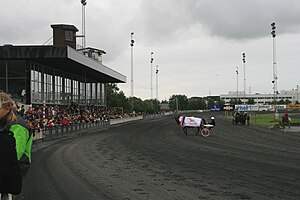
Forus Travbane
Distance: Approx. 1342 meters
Latitude and longitude: 58.89083333,5.72472222
Forus Travbane is a harness racing track located at Forus in Stavanger, Norway. The course is 950 meters (3,120 ft). Owned by Norwegian Trotting Association, its tote betting is handled by Norsk Rikstoto.

Lura Church
Church in Rogaland, Norway
Distance: Approx. 1191 meters
Latitude and longitude: 58.872646,5.731667
Lura Church (Norwegian: Lura kirke) is a parish church of the Church of Norway in the large Sandnes municipality in Rogaland county, Norway. It is located in the borough of Lura in the northern part of the city of Sandnes in the extreme western part of the municipality. It is the church for the Lura parish which is part of the Sandnes prosti (deanery) in the Diocese of Stavanger.
Weather in this IP's area
few clouds
10 Celsius
10 Celsius
10 Celsius
12 Celsius
1030 hPa
90 %
1030 hPa
1027 hPa
10000 meters
0.51 m/s
100 degree
20 %
07:11:11
19:51:53