Country:
 Norway
Region:
City:
Latitude and Longitude:
Time Zone:
Postal Code:
IP information under different IP Channel
ip-api
Country
Region
City
ASN
Time Zone
ISP
Blacklist
Proxy
Latitude
Longitude
Postal
Route
IPinfo
Country
Region
City
ASN
Time Zone
ISP
Blacklist
Proxy
Latitude
Longitude
Postal
Route
MaxMind
Country
Region
City
ASN
Time Zone
ISP
Blacklist
Proxy
Latitude
Longitude
Postal
Route
Luminati
Country
NOASN
Time Zone
Europe/Oslo
ISP
Globalconnect As
Latitude
Longitude
Postal
db-ip
Country
Region
City
ASN
Time Zone
ISP
Blacklist
Proxy
Latitude
Longitude
Postal
Route
ipdata
Country
Region
City
ASN
Time Zone
ISP
Blacklist
Proxy
Latitude
Longitude
Postal
Route
Popular places and events near this IP address
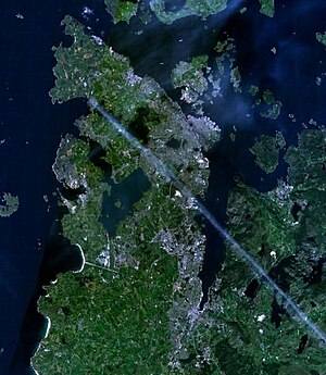
Hafrsfjord
Fjord in Norway
Distance: Approx. 3948 meters
Latitude and longitude: 58.928,5.6485
Hafrsfjord or Hafrsfjorden is a fjord in the Stavanger Peninsula in Rogaland county, Norway. The 9-kilometre (5.6 mi) long fjord forms the border between the municipalities of Stavanger and Sola. On the west side of the fjord is the large village of Tananger, on the south is the village of Solakrossen, and on the east end of the fjord is the borough of Madla in the city of Stavanger.

Tananger
Village in Western Norway, Norway
Distance: Approx. 468 meters
Latitude and longitude: 58.93611111,5.57388889
Tananger is a large village and urban area in Sola municipality in Rogaland county, Norway. The urban area is located on the west side of the Stavanger Peninsula between the North Sea and the Hafrsfjorden. It lies about 10 kilometres (6.2 mi) southwest of the city centre of Stavanger.

Madla
Borough in Western Norway, Norway
Distance: Approx. 4369 meters
Latitude and longitude: 58.95,5.65
Madla is a borough of the city of Stavanger which lies in the southwestern part of the large municipality of Stavanger in Rogaland county, Norway. It lies in the western part of the city, along the coast of the Hafrsfjorden. The 13.87-square-kilometre (3,430-acre) borough has a population (2017) of 21,130.
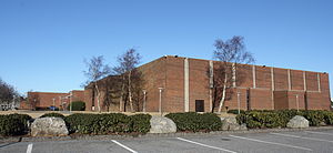
International School of Stavanger
School in Stavanger, Norway
Distance: Approx. 4603 meters
Latitude and longitude: 58.95,5.65444444
The International School of Stavanger (ISS), previously known as the Stavanger American School (SAMS), has existed in Stavanger since 1966 and at last count was the largest independent school in Norway. They are an English speaking, non-profit international school, educating students from Pre-school through Grade 12. They currently have around 600 students from over 50 countries; this includes 19% Americans; 17% British; and 16% Norwegians, which are their three largest groups.
Kvernevik
Neighbourhood in the city of Stravanger, Norway
Distance: Approx. 3567 meters
Latitude and longitude: 58.96416667,5.60055556
Kvernevik is a neighborhood (delområde) in the city of Stavanger which lies in the southwestern part of the large municipality of Stavanger in Rogaland county, Norway. It is located in the borough of Madla, located at the mouth of the Hafrsfjorden. The 1.46-square-kilometre (360-acre) neighborhood had a population in 2005 of 4,714 people.
Sunde, Stavanger
Distance: Approx. 3755 meters
Latitude and longitude: 58.9622,5.616
Sunde is a neighborhood (delområde) in the city of Stavanger which lies in the southwestern part of the large municipality of Stavanger in Rogaland county, Norway. It is located in the borough of Madla, located along the Hafrsfjorden, just south of Kvernevik. The neighborhood has a population of 4,104 which is distributed over an area of 5.74 square kilometres (1,420 acres).

Flatholmen Lighthouse
Coastal lighthouse in Sola, Norway
Distance: Approx. 1940 meters
Latitude and longitude: 58.9225,5.555
Fladholmen Lighthouse or Flatholmen Lighthouse (Norwegian: Fladholmen/Flatholmen fyr) is a coastal lighthouse in Sola municipality in Rogaland county, Norway. The lighthouse is located on a small, flat islet located just west of the village of Tananger. The lighthouse was established in 1862, rebuilt in 1952, and replaced with an electric lamp in 1984.
Revheim Church
Church in Rogaland, Norway
Distance: Approx. 4180 meters
Latitude and longitude: 58.952286,5.644057
Revheim Church (Norwegian: Revheim kirke) is a parish church of the Church of Norway in the southern part of the large Stavanger Municipality in Rogaland county, Norway. It is located in village of Kvernevik in the borough of Madla in the western part of the city of Stavanger. It is the church for the Hafrsfjord parish which is part of the Ytre Stavanger prosti (deanery) in the Diocese of Stavanger.

Sunde Church
Church in Rogaland, Norway
Distance: Approx. 3913 meters
Latitude and longitude: 58.965608,5.60972
Sunde Church (Norwegian: Sunde kirke) is a parish church of the Church of Norway in the southern part of the large Stavanger Municipality in Rogaland county, Norway. It is located in the village of Sunde in the borough of Madla in the western part of the city of Stavanger. It is the church for the Sunde parish which is part of the Ytre Stavanger prosti (deanery) in the Diocese of Stavanger.

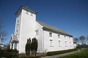
Tananger Church
Church in Rogaland, Norway
Distance: Approx. 1302 meters
Latitude and longitude: 58.935359,5.60317
Tananger Church (Norwegian: Tananger kirke) is a parish church of the Church of Norway in Sola Municipality in Rogaland county, Norway. It is located in the village of Tananger. It is the church for the Tananger parish which is part of the Tungenes prosti (deanery) in the Diocese of Stavanger.

Tananger Chapel
Church in Rogaland, Norway
Distance: Approx. 1174 meters
Latitude and longitude: 58.935175,5.60097
Tananger Chapel (Norwegian: Tananger kapell; historically called Tananger Church) is a historic parish church of the Church of Norway in Sola Municipality in Rogaland county, Norway. It is located in the village of Tananger. It used to be the church for the Tananger parish which is part of the Tungenes prosti (deanery) in the Diocese of Stavanger.
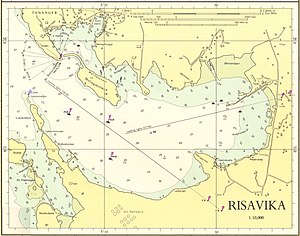
Risavika
Distance: Approx. 1125 meters
Latitude and longitude: 58.92518,5.59091
Risavika is a harbour located in Sola municipality in Rogaland county, Norway. Risavika harbour is an important transportation hub for nearby Stavanger, as well as port facility for shipping and the Norwegian oil industry.
Weather in this IP's area
few clouds
11 Celsius
10 Celsius
10 Celsius
12 Celsius
1030 hPa
73 %
1030 hPa
1030 hPa
10000 meters
0.51 m/s
100 degree
20 %
07:11:47
19:52:33