Country:
 Great Britain
Region:
City:
Latitude and Longitude:
Time Zone:
Postal Code:
IP information under different IP Channel
ip-api
Country
Region
City
ASN
Time Zone
ISP
Blacklist
Proxy
Latitude
Longitude
Postal
Route
IPinfo
Country
Region
City
ASN
Time Zone
ISP
Blacklist
Proxy
Latitude
Longitude
Postal
Route
MaxMind
Country
Region
City
ASN
Time Zone
ISP
Blacklist
Proxy
Latitude
Longitude
Postal
Route
Luminati
Country
GBASN
Time Zone
Europe/London
ISP
Daisy Corporate Services Trading Ltd
Latitude
Longitude
Postal
db-ip
Country
Region
City
ASN
Time Zone
ISP
Blacklist
Proxy
Latitude
Longitude
Postal
Route
ipdata
Country
Region
City
ASN
Time Zone
ISP
Blacklist
Proxy
Latitude
Longitude
Postal
Route
Popular places and events near this IP address

Flackwell Heath
Village in Buckinghamshire, England
Distance: Approx. 1317 meters
Latitude and longitude: 51.60087,-0.71205
Flackwell Heath is a village in the civil parish of Chepping Wycombe on the outskirts of High Wycombe, Buckinghamshire, England. With an elevation of about 150 metres (490 ft), in the Chiltern Hills. It has a population of around 6000.

Loudwater, Buckinghamshire
Village in Buckinghamshire, England
Distance: Approx. 1075 meters
Latitude and longitude: 51.606025,-0.692297
Loudwater is a village in the parish of Chepping Wycombe in Buckinghamshire, England. It is located in the valley to the east of High Wycombe, on the A40 London Road.

Chepping Wycombe
Civil parish in Buckinghamshire, England
Distance: Approx. 665 meters
Latitude and longitude: 51.6081,-0.6972
Chepping Wycombe is a civil parish in the ceremonial county of Buckinghamshire, England. The parish includes the three large villages of Tylers Green, Loudwater, and Flackwell Heath. The central part of the parish comprises extensive business and industrial development lying adjacent and underneath an elevated section of the M40 in the valley of the River Wye.
Flackwell Heath F.C.
Association football club in England
Distance: Approx. 994 meters
Latitude and longitude: 51.60416667,-0.71222222
Flackwell Heath Football Club is a football club based in Flackwell Heath, near High Wycombe in Buckinghamshire, England. Affiliated to the Berks & Bucks Football Association, they are currently members of the Southern League Division One Central and play at Wilks Park.
Marlow United F.C.
Association football club in England
Distance: Approx. 982 meters
Latitude and longitude: 51.60426667,-0.71216389
Marlow United Football Club is a football club based in Marlow, Buckinghamshire, England. They were established in 1977 and were among the founding members of the Reading Football League in 1989.

Wycombe Marsh
Human settlement in England
Distance: Approx. 1337 meters
Latitude and longitude: 51.616405,-0.72263
Wycombe Marsh is an area of High Wycombe, Buckinghamshire, England. It lies on the River Wye and the A40 road, approximately 1.5 miles (2.4 km) south-east of High Wycombe town centre, and approximately 1 mile (1.6 km) north-west of Loudwater. Wycombe Marsh is in the Ryemead ward of High Wycombe, which had a population of 7,188 at the 2011 census.

Sheepridge
Hamlet in Buckinghamshire, England
Distance: Approx. 2032 meters
Latitude and longitude: 51.598,-0.724
Sheepridge is a hamlet in the parish of Little Marlow, in Buckinghamshire, England. The hamlet is located in a small indentation of an outlying part of the Chiltern Hills. It can be found on Sheepridge Lane, which connects Flackwell Heath to Well End and Bourne End.

Wycombe Summit
Distance: Approx. 1797 meters
Latitude and longitude: 51.6136,-0.7306
The Wycombe Summit was a dry ski slope situated in High Wycombe, Buckinghamshire. It has been closed since 22 November 2005, when a fire destroyed the lodge. In November 2016, Wycombe District Council approved a planning application for 30 dwellings on the site.
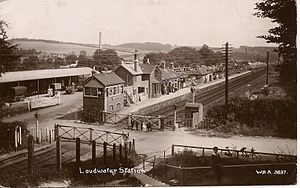
Loudwater railway station
Former railway station in England
Distance: Approx. 802 meters
Latitude and longitude: 51.6049,-0.7014
Loudwater railway station was a railway station which served Loudwater, Buckinghamshire and Flackwell Heath, on the Wycombe Railway.
Micklefield, High Wycombe
Area of High Wycombe, Buckinghamshire, England
Distance: Approx. 2145 meters
Latitude and longitude: 51.62998,-0.71506
Micklefield is a ward of High Wycombe, Buckinghamshire, located on the eastern side of the town. Surrounded on one side by the Chiltern Hills and King's Wood, it neighbours the villages of Penn and Tylers Green, as well as being adjacent to Wycombe Marsh. Some points in the Micklefield area rise to an altitude of some 450 feet, and there are some great views over the Wycombe valley.
Gomm Valley
Distance: Approx. 1082 meters
Latitude and longitude: 51.6215,-0.7057
Gomm Valley is a 4-hectare (9.9-acre) biological Site of Special Scientific Interest in Micklefield, a district of High Wycombe in Buckinghamshire. It is managed by the Berkshire, Buckinghamshire and Oxfordshire Wildlife Trust and is part of the Chilterns Area of Outstanding Natural Beauty. The local planning authority is Wycombe District Council.

Holtspur Bank
Local nature reserve in Buckinghamshire, England
Distance: Approx. 2215 meters
Latitude and longitude: 51.603167,-0.675889
Holtspur Bank is a 6.6 hectares (16 acres) Local Nature Reserve in Beaconsfield in Buckinghamshire. It is owned and managed by Beaconsfield Town Council. Half of the site is chalk grassland and half ancient woodland.
Weather in this IP's area
overcast clouds
10 Celsius
10 Celsius
9 Celsius
12 Celsius
1015 hPa
94 %
1015 hPa
1007 hPa
10000 meters
2.92 m/s
7.57 m/s
176 degree
89 %
07:34:09
18:00:58