Country:
Region:
City:
Latitude and Longitude:
Time Zone:
Postal Code:
IP information under different IP Channel
ip-api
Country
Region
City
ASN
Time Zone
ISP
Blacklist
Proxy
Latitude
Longitude
Postal
Route
Luminati
Country
ASN
Time Zone
Europe/Oslo
ISP
Globalconnect As
Latitude
Longitude
Postal
IPinfo
Country
Region
City
ASN
Time Zone
ISP
Blacklist
Proxy
Latitude
Longitude
Postal
Route
db-ip
Country
Region
City
ASN
Time Zone
ISP
Blacklist
Proxy
Latitude
Longitude
Postal
Route
ipdata
Country
Region
City
ASN
Time Zone
ISP
Blacklist
Proxy
Latitude
Longitude
Postal
Route
Popular places and events near this IP address

Bryggen
UNESCO World Heritage Site in Bergen, Norway
Distance: Approx. 137 meters
Latitude and longitude: 60.39722222,5.32305556
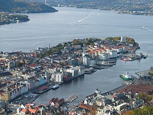
Bryggen (the dock), also known as Tyskebryggen (Norwegian: [ˈtʏ̀skəˌbrʏɡːn̩], the German dock), is a series of Hanseatic heritage commercial buildings lining up the eastern side of the Vågen harbour in the city of Bergen, Norway. Bryggen has been on the UNESCO list for World Cultural Heritage sites since 1979. The city of Bergen was founded around 1070 within the boundaries of Tyskebryggen.

Hanseatic Museum and Schøtstuene
Museum in Bergen, Norway
Distance: Approx. 265 meters
Latitude and longitude: 60.3961,5.3262
Hanseatic Museum and Schøtstuene (Det Hanseatiske Museum og Schøtstuene) is a museum in the city of Bergen, Norway.
Bryggens Museum
Museum in Bergen, Norway
Distance: Approx. 243 meters
Latitude and longitude: 60.39838,5.32277
Bryggens Museum is a museum located in Bergen, Norway. During 1955, parts of the historic district of Bryggen were ravaged by a fire. During subsequent archaeological excavations a number of objects were uncovered, providing an insight into commerce, shipping, handicrafts and everyday life during the Medieval Period.

Battle of Vågen
1665 naval battle between the Dutch Republic and England
Distance: Approx. 283 meters
Latitude and longitude: 60.39777778,5.31722222
The Battle of Vågen was a naval battle between a Dutch merchant and treasure fleet and an English flotilla of warships in 2 August 1665 as part of the Second Anglo-Dutch War. The battle took place in Vågen (meaning "the bay, voe" in Norwegian), the main port area of neutral Bergen, Norway. Due to a delay in orders, the Norwegian commanders took the side of the Dutch, contrary to the secret intentions of the King of Norway and Denmark.

Strandgaten, Bergen
Street in Bergen, Norway
Distance: Approx. 232 meters
Latitude and longitude: 60.3958,5.3173
Strandgaten is a street in the city centre of Bergen, Norway, west of the bay of Vågen. It starts at Torgallmenningen and follows the eastern shore of the Nordnes peninsula to Tidemands gate, where it becomes Nordnesgaten. The easternmost quarter of Strandgaten is a regular two-way street, while it is an eastbound one-way street between Tollbodallmenningen and Holbergsallmenningen, and between Østre Murallmenningen and Torgallmenningen.

Buekorps Museum
Museum in Norway
Distance: Approx. 186 meters
Latitude and longitude: 60.3948,5.3199
The Buekorps Museum (Buekorpsmuseet) is a museum in Bergen, Norway. It is dedicated to the traditional neighborhood youth marching organization, Buekorps. The Buekorps Museum was established in 1977 and is located in Murhvelvingen on Østre Muralmenning.
Vågen, Bergen
Distance: Approx. 241 meters
Latitude and longitude: 60.3976,5.3179
Vågen is a bay in the centre of the city of Bergen in Vestland county, Norway. It is the central harbour of the city centre, and is the center of the historical core of the city. The city of Bergen originated on the east shore of the bay, and from there it expanded to the southern and western shores over a few centuries.
Sacking of Bergen (1393)
Distance: Approx. 146 meters
Latitude and longitude: 60.3971,5.3235
The Sacking of Bergen in 1393 was one of two attacks on Bergen by the Victual Brothers, a former trading guild turned to piracy. The second attack was many years later, in 1429. The Victual Brothers raided the town, pillaged and looted goods and killed the garrison and possibly also civilians.

Bryggen Runic inscription 257
Distance: Approx. 204 meters
Latitude and longitude: 60.398,5.32
The Bergen rune charm is a runic inscription on a piece of wood found among the medieval rune-staves of Bergen. It is noted for its similarities to the Eddaic poem Skírnismál (particularly stanza 36); as a rare example of a poetic rune-stave inscription; and of runes being used in love magic. The inscription has number 257 in the Bryggen inscriptions numbering and N B257 (Norway Bryggen no.
Operation Guidance
Distance: Approx. 170 meters
Latitude and longitude: 60.3972,5.3189
Operation Guidance was an Australian-British raid during World War II in 1944. The British X-class submarine X24, entered Bergen harbour in German-occupied Norway on a mission to sink a large floating dock. After being detected and shaking off their pursuer, X24 made it to the target area, but faulty intelligence and incorrect charts led them to lay their charges not on the floating dock, but on a large German ship nearby, which was sunk in the explosion.
Bryggen Runic inscription 145
Distance: Approx. 204 meters
Latitude and longitude: 60.398,5.32
Bryggen inscription 145 (N B145 in Rundata) is a runic inscription on a wooden stick found among the medieval rune-staves of Bergen. It has four sides, and dates to around the year 1200. It is notable not only for containing a rare Skaldic love poem in the form of a complete dróttkvætt stanza, but also a quote from the classical Latin poet Virgil, illustrating the coexistence of native Norse and Classical education in medieval Norway.
Swan pharmacy
Distance: Approx. 296 meters
Latitude and longitude: 60.39378889,5.32318056
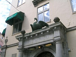
Swan pharmacy or Svaneapoteket in Bergen, Norway is the oldest pharmacy in Norway. It was established in 1595. The original building burned down in a fire in 1916 and it was rebuilt by the architects Fredrik Arnesen and Darre Kaarbø.
Weather in this IP's area
light intensity drizzle
7 Celsius
5 Celsius
7 Celsius
7 Celsius
1022 hPa
93 %
1022 hPa
1022 hPa
6000 meters
3.6 m/s
130 degree
75 %
08:37:23
16:09:13


